
Spring has just about sprung, and with that begins our primary severe weather season in Texas. Severe thunderstorms can and do happen year-round in Texas. However, our most active period of severe thunderstorms tends to occur in the spring months. While more rowdy thunderstorms produce hazardous impacts, our springtime storms also bring us much-needed rainfall.
Most storms do not produce tornadoes, destructive hail, or damaging wind gusts. That being said, it would be wise to remain weather-aware since Mother Nature can throw tantrums galore. Today is not looking like a major tornado day, but it only takes one nasty storm coming down your street to make it a ‘big day’.
Severe Weather Outlook
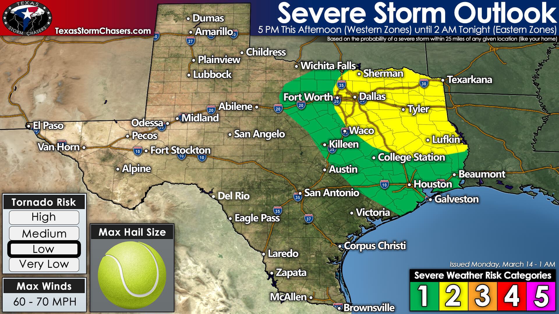
The Storm Prediction Center has highlighted North Texas, Northeast Texas, and East Texas for a risk of severe thunderstorms later today and tonight. On the five-level risk scale, which is a way to convey the ‘coverage’ of severe storms, we have a level two risk.
Level five is the highest risk and is quite rare – reserved for significant tornado outbreaks and Derechos. A level one risk occurs more frequently and means relatively isolated stronger thunderstorms. For more information on the severe weather risk scale, please visit our info page here. You can always view the latest severe weather outlooks for Texas on our website too.
Storm Timing & Threats
The threat for thunderstorms will l increase after 5 PM east of a surface dryline across North Texas. While the exact placement will be critical on where storms fire develops, we anticipate the dryline to set up around Interstate 35W/35 late this afternoon. If the dryline sets up a bit further west, the chance for storms would likewise expand west. Isolated to scattered thunderstorms may also develop late this afternoon further east, closer to Tyler.

Not all storms will be severe later today. However, we anticipate some storms to become supercelluar with a risk of producing large hail and localized damaging wind gusts. One or two intense supercelluar thunderstorms may be capable of producing very large hail during the first couple hours of their lifecycle. Thunderstorms will tend to move east, perhaps eventually turning east/southeast this evening.
There is a low risk for a couple of tornadoes from the eastern D/FW Metroplex into East Texas this evening. The overall threat for tornadoes will be tempered by ‘just in time moisture return,’ which will keep cloud bases a bit higher. However, as temperatures cool just after sunset, we may see conditions become a bit more favorable for a tornado if any intense, discrete supercells are ongoing.
With time this evening, it seems likely we’ll see thunderstorms congeal into one or two squall lines. The strongest storms within the squall line may produce ‘pocket-change size hail’ (dimes, pennies, quarters, half-dollars) along with localized wind gusts over 60 miles per hour.
Depending on how far south/southwest storms form this evening, we may see one squall line move into Southeast Texas and the Golden Triangle early Tuesday morning. Other storms move into Arkansas and Louisiana further to the north. I’m hopeful we’ll conclude our severe weather threat by 2-3 AM Tuesday.
Review your Severe Weather Safety Plans
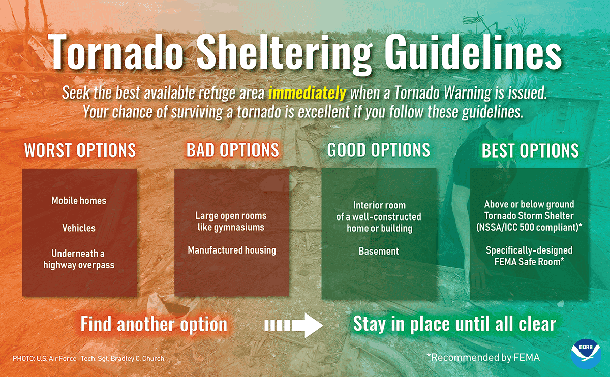
Since this is one of the first severe weather chances of the year, I encourage folks to go over their severe weather safety plans. Know where you and your family will go if a dangerous thunderstorm approaches your area. You can review severe weather safety tips by clicking here.
Storm Chasing & Live Coverage Plans
We’ll have multiple team members out chasing the storms later today and tonight. Some of them will likely be live streaming videos to our YouTube channel. Those live videos will also be automatically ingested into our website and the TSC mobile app. In addition, I’ll be ‘in the office’ and ready to conduct live severe weather coverage should it be needed. That live coverage will be available on nearly every one of our social media platforms, in addition to our website and free TSC mobile app.


0 Comments