
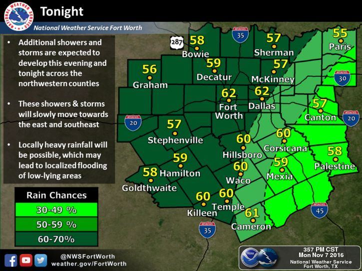
Rain and storm chances continue into the overnight hours, mainly across north central Texas, central Texas and the south Texas plains region. Coverage will tend to be more scattered overnight than we saw during the day, but rainfall rates within the clusters of storms that continue to percolate overnight will have the potential to produce additional rainfall between 1 to 3 inches. A few rumbles of thunder will be possible, but the threat of seeing any severe weather will be quite low. A weakish cold front arrives early tomorrow and slowly makes its way through the state helping to push the rainfall south while dragging drier air in behind it. Chances for rain will carry forward through Tuesday, then we begin to transition to a drier pattern behind the cold front for the remainder of the work week ahead. We won’t be completely without rain, but we will see a marked decrease over what we’ve seen the past 24 to 48 hours.

Here’s a look at the latest forecast animation through around 7am tomorrow. As always, keep in mind this is just what a computer model thinks will happen, and reality could look a bit different. Check the radar before heading out tomorrow and allow extra time for your commute to work or school!

Temps overnight will be cool but still average above normal for this time of the year. Behind the cold front tomorrow night, we’ll see overnight lows fall closer to where they should be for this time of the year. Parts of the Texas panhandle will see temps drop below freezing tomorrow night as well. A Freeze Watch will go into effect tomorrow evening with temperatures Tuesday night expected to range from the upper 20s to low 30s by early Wednesday morning. Just a little reminder that winter is not too far away!


0 Comments