
Beautiful weather will continue for the remainder of the weekend across Texas. High temperatures on Sunday will be several degrees warmer than today. There will be an increased risk for fast-moving grass fires on Sunday, Monday, and Tuesday. High temperatures in the middle to upper 90s are likely on Tuesday across South Texas – thanks to compressional heading ahead of crashy the cold front. That cold front will bring a series of active weather days to Texas, though it remains unclear how active each of those days will be.
Rain chances increase Monday Evening
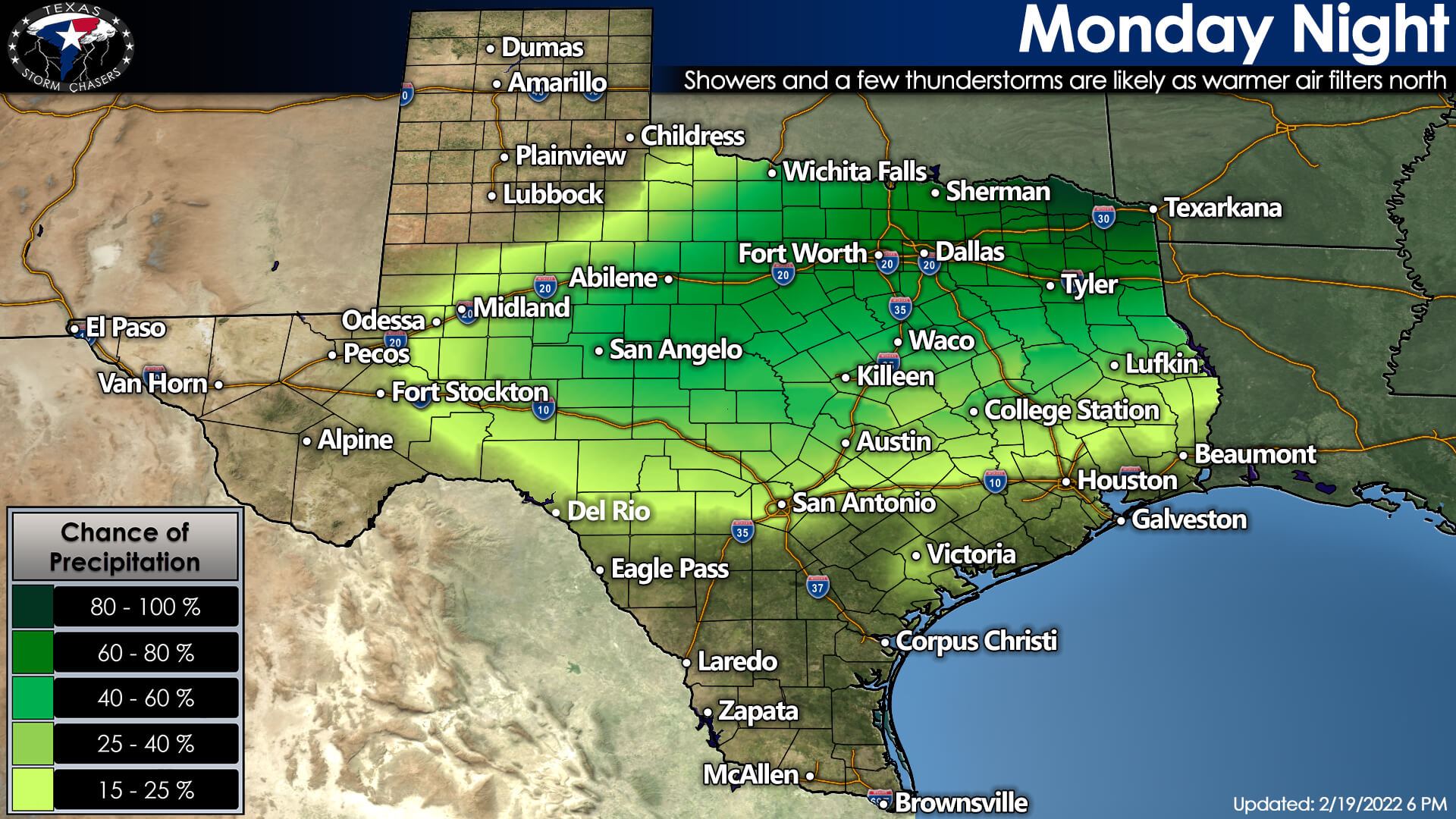
First up on our list of ‘fun’ will be increasing rain chances Monday evening. Warm-air advection and stronger south winds will pump moisture inland from the Gulf of Mexico. We’ll have enough moisture and lift in place by Monday night to support showers and a few thunderstorms. Most of the activity will be light, but it will not make for the most pleasant night. A few thunderstorms are more likely across Texoma, North Texas, and Northeast Texas. We continue to monitor a low risk for a few severe storms with hail, but that potential remains unclear. We’ll fine-tune the possibility for stronger stormies tomorrow. Either way, we’re not expecting a big-time severe weather event in Texas.
Crashy the Cold Front arrives Tuesday
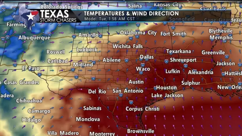
A strong arctic cold front will begin pushing south into Texas on Tuesday. As usual, the Panhandle will be the first to enjoy the blast of chilly air. Crashy the cold front should reach Interstate 20 from the Permian Basin northeastward to the D/FW Metroplex around lunchtime Tuesday. We’re expecting the front to arrive around dinner-time, or a bit sooner, in the Hill Country, Central Texas, and the Brazos Valley. The front will be pushing to the Southeast Texas coast and into South Texas early Wednesday morning. Gusty north winds will announce the cold front’s arrival at your location. Temperatures will drop by twenty degrees within a few hours after that.
Wind chill values will be ten to fifteen degrees lower than the actual air temperature. The location of the freezing line late Tuesday night through Thursday will be an essential detail we’ll need to nail down. Where we have precipitation, temperatures below freezing at the surface could deal with winter mischief. Those above freezing will ‘enjoy’ a chilly rain. The freezing line will not remain static but will meander north and south with the diurnal cycle (daytime heating) along with some other factors I won’t detail.
Snow and Ice Chances on Wednesday & Thursday
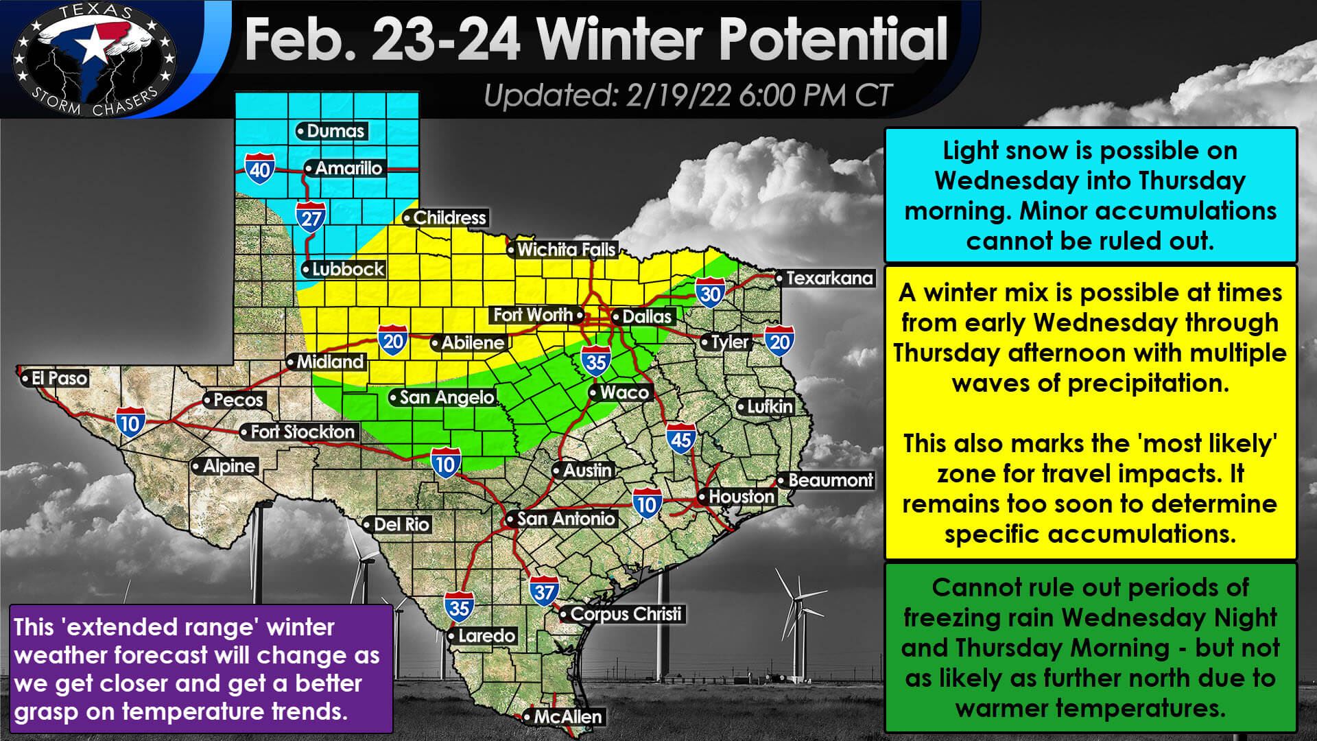
Multiple rounds of light precipitation are expected from early Wednesday morning through Thursday afternoon across the northern two-thirds of Texas. With a cold air mass in place, we may be dealing with winter mischief. We are reasonably confident in a layer of warm air a few thousand feet above the surface during the event. A ‘warm nose’ means we’ll be dealing with a mix of freezing rain and sleet for most folks. It does look like we’ll be cold enough for mostly snow across the Texas Panhandle and West Texas if we have precipitation that far west on Wednesday.
It remains too soon to try and pin down specific precipitation types and accumulations. If we have a bit more cold air than expected, that would move the freezing line and associated ‘ice line’ further south. Likewise, if the freezing line is further north, the chance for winter weather would move north. Most weather model guidance is not showing a significant winter storm. Still, with ice, even minimal accumulations can cause headaches with elevated surfaces.
With multiple rounds of light precipitation, we expect periods of dry weather (probably Wednesday afternoon and Wednesday evening). Those dry periods could result in melting where we see any accumulations and temperatures rise above freezing. We’ll have to factor that information into future forecasts when it comes time to pin-down accumulations.
The highest relative probability for some travel impacts on Wednesday and Thursday, as it stands today, is across the Big Country, Northwest Texas, Texoma, and western North Texas. The D/FW Metroplex is right on the edge as usual for these events. Western and northern sections of the D/FW Metroplex (Weatherford to Denton to Bonham) have a higher winter weather chance than Cleburne, Ennis, and Terrell.
The conclusion
We’re also talking about a possible event four days away, so we remain in the ‘trying to pin down the more prominent features’ phase. We will get into the finer details once we’re within two days. Precipitation chances will conclude Thursday afternoon or early Thursday evening from west to east. The warmup will begin on Friday and continue into next weekend.


0 Comments