
Tropical Storm Nicholas is a disorganized cyclone this afternoon. After developing a defined surface circulation this morning, the tropical storm is still in the formative stages of organization. Several small low-level circulations (or swirls, if you prefer) are rotating around a large area of lowered pressures. Once one of those surface circulations takes hold, we’ll likely see Nicholas become more organized – perhaps quickly. That process will likely occur tonight or early Monday.
Track Map & Wind Forecast
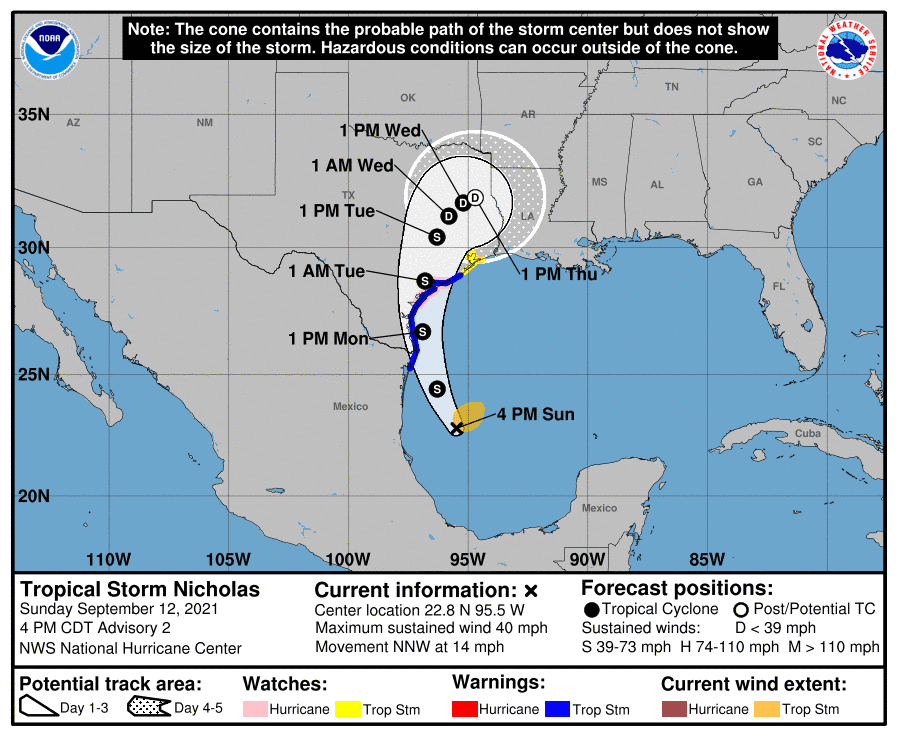
Weather model guidance has ramped up the intensity guidance for Nicholas. While we are not expecting a significant hurricane, there is increasing potential Nicholas may briefly attain hurricane intensity before making landfall late tomorrow night on the Middle Texas Coast. If Nicholas trends west, the system will likely be weaker (wind/surge wise). An eastward shift would allow for more time over water and increase the probability of a hurricane. The strongest winds will be confined to a small portion of the northeast quadrant regardless of the eventual intensity. Minor wind damage in the form of broken tree limbs, roof shingles flying off, and some power outages are possible.
Storm Surge
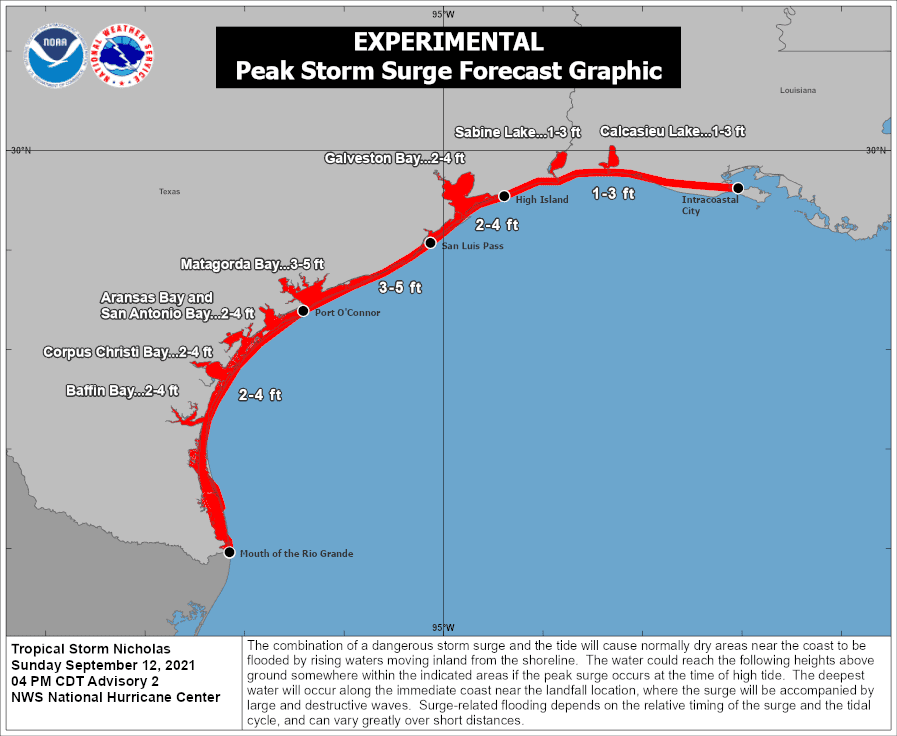
Given the increase in intensity guidance, the threat of a damaging storm surge has also increased near the projected landfall location. A storm surge of three to five feet above normal tides is forecast between Port O’Connor and San Luis Pass. A two to four-foot storm surge above normal tides is predicted from the Mouth of the Rio Grande in Deep South Texas north to High Island on the Upper Texas Coast. The surge will lessen from there going east into Louisiana.
Tornado Threat
A few tornadoes will be possible beginning tomorrow across the Middle Texas Coast as the northeast quadrant of Nicholas gets closer to the coast. With a slow movement to the north and eventually northeast through Thursday, there may be some tornado threat for several days this week in Southeast Texas and ultimately East Texas. Tornadoes associated with tropical cyclones are typically very brief and weak. However, they can still take off a roof, knock trees down on power infrastructure and structures, and do significant damage to mobile homes.
Heavy Rain & Flooding
Slow-moving tropical systems have long been known to be troublesome in the rainfall department in Texas. Let me be clear by saying every storm is unique. We’re talking about a range of rainfall possibilities that will depend on the track of Nicholas.
Folks to the west of the system will see far less rain than those to the east. A sharp gradient in rain chances and rain accumulations is expected west and north of the cyclone.
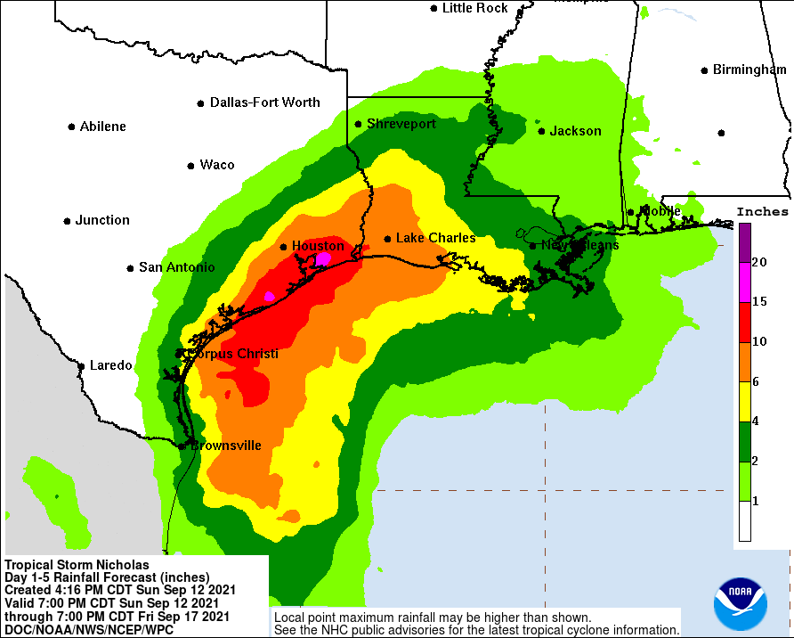
This week, a widespread, heavy rainfall event is forecast for the Middle Texas Coast, Coastal Plains, Southeast Texas, and the Piney Woods of East Texas. Several inches of rain is likely. There will be corridors of far more significant rain totals (exceeding 10 to 15 inches) – potentially impacting Southeast Texas and the Upper Texas Coast.
Yes, that possibility does include the Houston metro. However, I don’t want to get overly specific yet. Let’s see how Nicholas behaves tonight and get a track firmed up tomorrow. If the current track and data do hold, we will likely have considerable flooding across portions of the Coastal Plains and Southeast Texas for several days this week. That threat does include the Houston metropolitan area – assuming the track doesn’t shift.
Hourly rainfall rates may exceed 3 to 4 inches at times in the heaviest cells – with training ‘or heavy rain moving over the exact locations’ probable. Given the slow movement of Nicholas, after it makes landfall, we could deal with a prolonged period of heavy to extreme rainfall.


0 Comments