
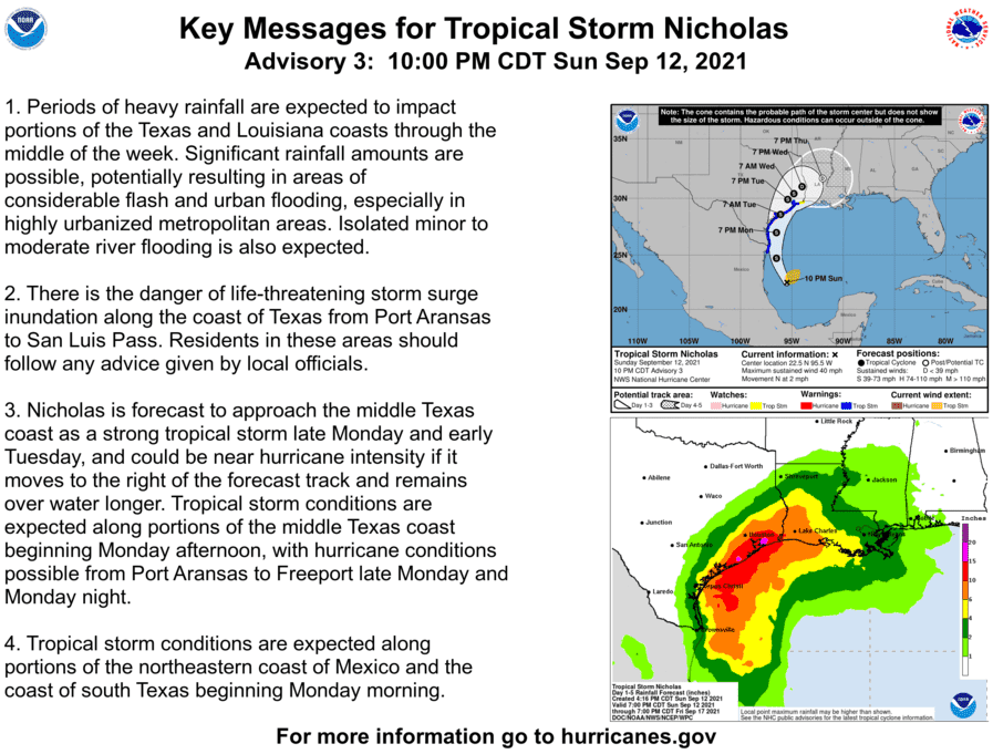
Tropical Storm Nicholas remains a disorganized cyclone this evening. Hurricane hunter aircraft investigating the system indicate the center may be reforming further north. As discussed earlier today, a tropical system in its formative stages tend can have multiple weak low-level centers. Once one of those low-level swirls takes hold, as we expect will happen tonight, the system will likely start to organize.
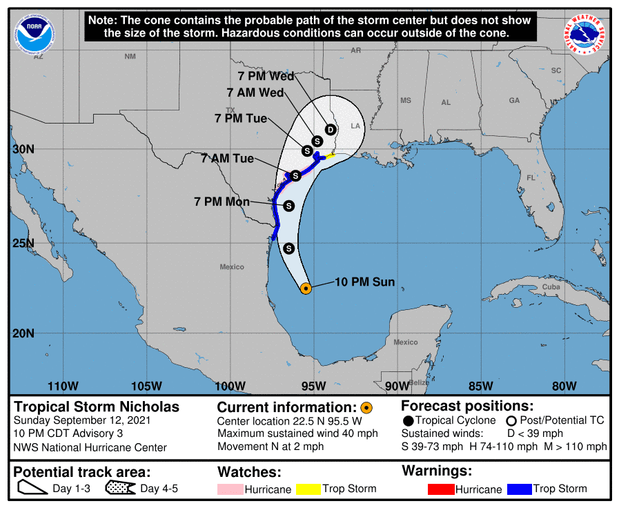
With a center reformation to the north expected, along with tonight’s weather model guidance trending a bit further to the east, we’ve seen the hurricane watch and tropical storm warning extended east along the Upper Texas Coast. A hurricane watch is now in effect from Port Aransas to Freeport. Tropical Storm Warnings are in place from the Mouth of the Rio Grande (Brownsville) north to High Island. A Storm Surge Warning is in effect from Port Aransas to San Luis Pass – including Aransas Bay, San Antonio Bay, and Matagorda Bay.
Nicholas only moving north at 2 miles per hour this evening. On Monday, a north/northwest movement is expected, with the storm passing offshore of Corpus Christi tomorrow night. Around 7 AM Tuesday, give or take a few hours, landfall is expected on the Middle Texas Coast as a strong tropical storm or a minimum hurricane (65 to 80 MPH sustained winds in a small section of the northeast quadrant). Most folks along the Texas Coast may see gusty winds, but not necessarily damaging winds. An exception could be within a small area where the storm makes landfall and where winds may gust upwards of 60 to 80 MPH for a time.
Storm Surge & Coastal Flooding
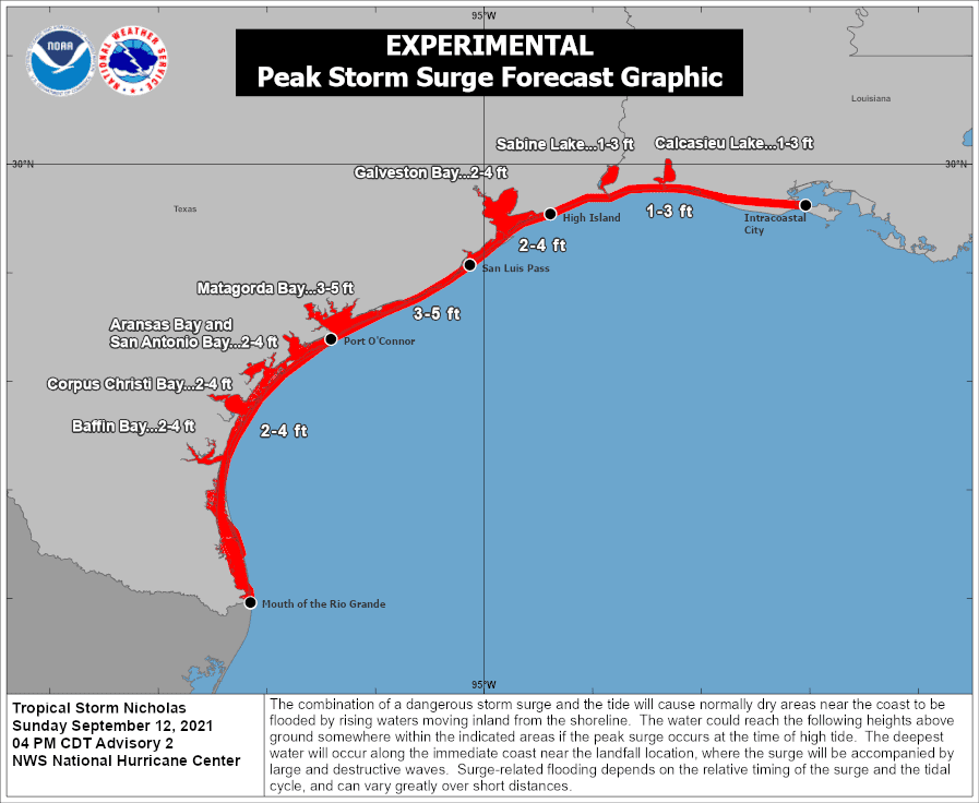
The combination of a dangerous storm surge and the tide will cause normally dry areas near the coast to be flooded by rising waters moving inland from the shoreline. The water could reach the following heights above ground somewhere in the indicated areas if the peak surge occurs at the time of high tide…
Port O’Connor to San Luis Pass TX including Matagorda Bay… 3-5 ft
San Luis Pass, TX to Rutherford Beach, LA including Galveston Bay…2-4 ftm
The mouth of the Rio Grande to Port O’Connor, TX…2-4 ft
Baffin Bay, Corpus Christi Bay, Aransas Bay, and San Antonio Bay…2-4 ft
Rutherford Beach, LA to Intracoastal City, LA…1-3 ft
Sabine Lake and Calcasieu Lake…1-3 ft
The deepest water will occur along the immediate coast in areas of onshore winds, where large and dangerous waves will accompany the surge. Surge-related flooding depends on the relative timing of the surge and the tidal cycle and can vary greatly over short distances. Please see products issued by your local National Weather Service forecast office for information specific to your area.
After landfall, Nicholas is likely to slow and begin turning north/northeast. It may continue crawling northeast on Tuesday and Wednesday – bringing intense rainfall to Southeast Texas and the Golden Triangle. Tonight’s forecast has the weakened system exiting Texas to the east sometime Thursday.
Tornado Risk
A few tornadoes are possible on Monday across the Coastal Plains and Middle Texas Coast. On Tuesday, the threat for a few tornadoes will spread into Southeast Texas and along the Upper Texas Coast. We may have to deal with a limited tornado threat in East Texas, Southeast Texas, and the Golden Triangle until the system moves into Louisiana on Thursday. Most tornadoes in tropical environments are very brief and weak. However, they can still cause damage – so treat any tornado warning like you would if it were spring.
Heavy Rain and Flooding
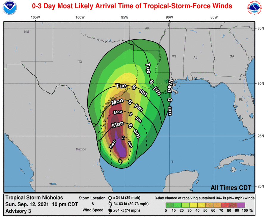
A multi-day, significant rainfall event is likely for the Middle Texas Coast, Upper Texas Coast, Southeast Texas, and the Golden Triangle. We’ll have rain ongoing at times tomorrow across the Rio Grande Valley and Lower Texas Coast. Rain chances will increase tomorrow night along the Middle Texas Coast, and Coastal Plains as Nicholas approaches landfall. Rain chances will increase on Tuesday across Southeast Texas, the Upper Texas Coast, and the Golden Triangle. We’ll likely be dealing with heavy rain until the system exits on Thursday.
The most intense rainbands may produce three to four inches of rain per hour – and continue for several hours in some locations. Some locations on the Upper Texas Coast may receive over one foot of rain. Still, we’ll have to get within 36 hours to really be able to ‘pin down’ specific corridors of extreme rain and severe flooding potential.


0 Comments