
Showers and thunderstorms ongoing this morning across the Big Country, North Texas, and Texoma should weaken through lunchtime. We can’t rule out a stronger storm with gusty winds, but widespread severe weather isn’t expected. Some flooding, including urban street flooding, is possible with heavier rains in the Permian Basin, Big Country, and Northwest Texas. Tropical moisture will allow for decent rainfall rates (it is almost summer, after all).
Timeline
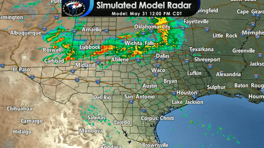
06Z HRRR: Simulated weather model radar this afternoon through Tuesday morning.
Trying to determine specific development locations for afternoon thunderstorms will be a ‘pin the tail on the donkey.’ New thunderstorm development should begin not long after lunchtime, where we have residual outflow boundaries leftover from this morning’s storms. This morning’s high-resolution models focus on West Texas, the Permian Basin, and southern Oklahoma early this afternoon. Depending on where the aforementioned boundaries are set up, those locations may shift. Additional development could also be ongoing this afternoon in North Texas, where residual outflow boundaries remain from this morning’s rain.
Once storms develop, they should grow upscale fairly quickly into clusters or line segments. Once upscale growth occurs, storms should move off to the east into Northwest Texas, the Big Country, the Concho Valley, and the Edwards Plateau late this afternoon. Scattered storms are likely to be underway further east by dinner-time in Texoma and North Texas. Rain is likely this evening and tonight across North Texas, Central Texas, the Hill Country, and South-Central Texas. If this morning’s storms end up making a mess of this afternoon’s forecast, the eventual outcome tonight maybe a bit different too.
Severe Weather Outlook for Final Day of May
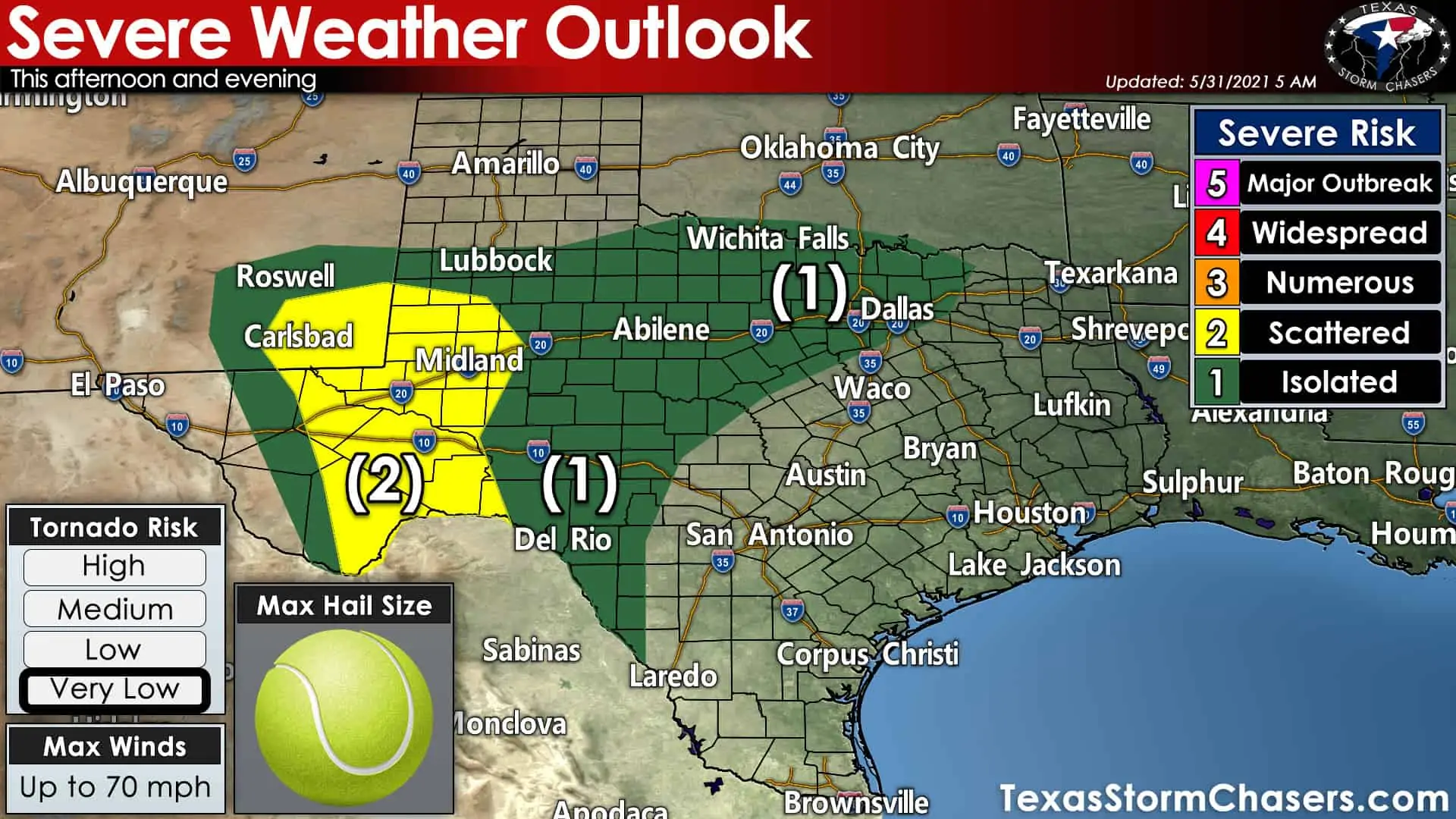
Today certainly isn’t a classic spring-time severe weather setup, but a few severe storms are still possible this afternoon and this evening. With all the rain this morning, we are not expecting widespread severe weather in most of the state today. A level one risk of severe weather includes North Texas, Texoma, Northwest Texas, the Big Country, Concho Valley, Edwards Plateau, and West Texas. A level one risk means isolated severe storms are possible.
The Storm Prediction Center does have a level two risk for severe storms, indicating slightly higher severe storm coverage across the Permian Basin and Southwest Texas. A brief tornado or two is possible, but we’re expecting the strongest storms to mainly be hailers with some localized damaging wind gusts. The most intense storms in the level two risk may produce very large hail up to the size of tennis balls, with smaller hail sizes further east.
Heavy Rain and Flooding A Concern Today & Tonight
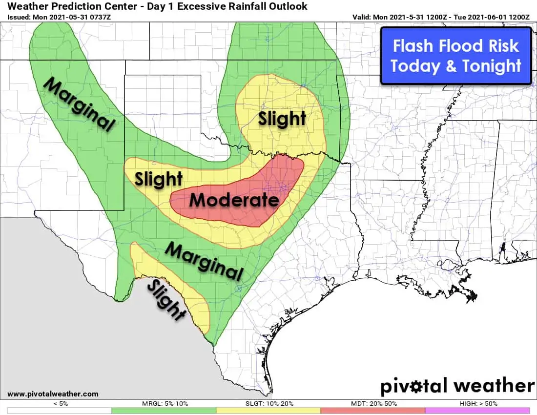
While a few severe storms are possible this afternoon, so will the threat of flash flooding. The Weather Prediction Center (WPC) has highlighted a moderate risk of flash flooding in the Big Country and North Texas today and tonight. That risk includes Sweetwater, Abilene, and all of the D/FW Metroplex. Localized flooding will also be possible across West Texas, the Permian Basin, the Edwards Plateau, and the Hill Country and South-Central Texas. We’ll have to keep an eye on areas that have had plenty of rain over the last few weeks. Another aspect will be where we have ‘training storms’ or multiple storms move over the same location. It won’t take much to get 2-4 inch per hour rainfall rates today out of heavy storms.
Rainfall Forecast through Mid-Week
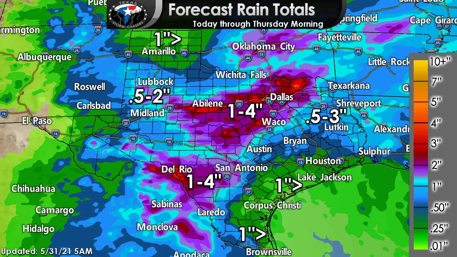
We may still be dealing with some thunderstorm chances through the week, although with less coverage across the north after tonight. Widespread one to four-inch rainfall totals is forecast from Del Rio and Laredo north/northeastward through the Big Country, North Texas, and Texoma. Localized rain totals over six inches are possible. Lower rain totals are forecast in the Borderland, Texas Panhandle, and the coast through Thursday morning. Hey, we could always be in the triple digits by now. At least we can try to fill some more lakes before we switch over into the summer doldrums (well, hopefully. I really don’t want to deal with tropical mischief yet).


0 Comments