
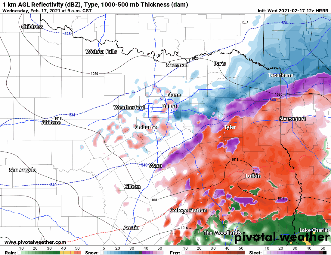
Another morning with yet another winter storm in progress across Texas. A winter mix, consisting of freezing rain and sleet, is generally falling south of Interstate 30 and east of Interstate 35 across the eastern third of Texas this morning. Places like Texarkana, Tyler, Corsicana, Nacogdoches, Bryan, Huntsville, and Jasper have accumulated ice or snow. Substantial ice accumulations have been reported on top of the snow that fell on Sunday. Stay home! A dangerous ice storm is underway, with damage to power infrastructure and trees likely. Track the ice/snow with our free interactive weather radar here.
Precipitation has mostly ended for the Interstate 35 corridor from the Red River to San Antonio. Spotty sleet/snow showers are possible through the early afternoon, but additional significant accumulations are unlikely for Interstate 35 metros. Road conditions, however, are going to be in rough shape all day. The combination of ice and snow accumulations may continue to damage power infrastructure and relatively weak structures (carports, for example). Falling ice from elevated objects will pose a significant concern over the coming days, mostly when we finally bust out of the arctic freeze.
Simulated weather model radar for Northeast & East Texas through this afternoon.
Freezing rain, sleet, and snow will continue falling in Northeast Texas and East Texas through the mid-afternoon hours. We previously thought it would be out of our hair by lunch-time, but it looks like it’ll be a bit longer. An additional three to six inches of sleet and snow is expected through mid-afternoon in Northeast Texas, with very severe ice accumulations of another one-half inch possible in the eastern Brazos Valley, southeastern North Texas, and East Texas. I cannot stress how dangerous this ice storm is becoming in terms of damage to trees, power infrastructure, and weakened structures. Roads will be practically impossible to travel on all day.
High temperatures this afternoon
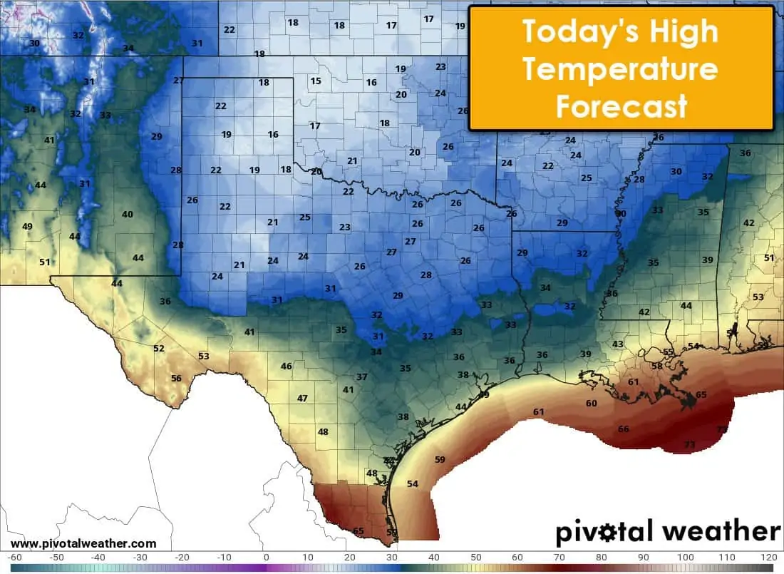
Today’s High-Temperature Forecast
Temperatures will not rise above freezing today across the northern half of Texas. On the other side of the spectrum, temperatures in the fifties and sixties are forecast this afternoon in the Rio Grande Valley and across Far Southwest Texas. Even where temperatures rise above freezing this afternoon, anything that manages to melt will likely freeze over into ice tonight. Slushy roads are dangerous and still quite hazardous to drive on – even if temperatures rise above freezing at a given location this afternoon.
Tonight’s Low-Temperature Forecast
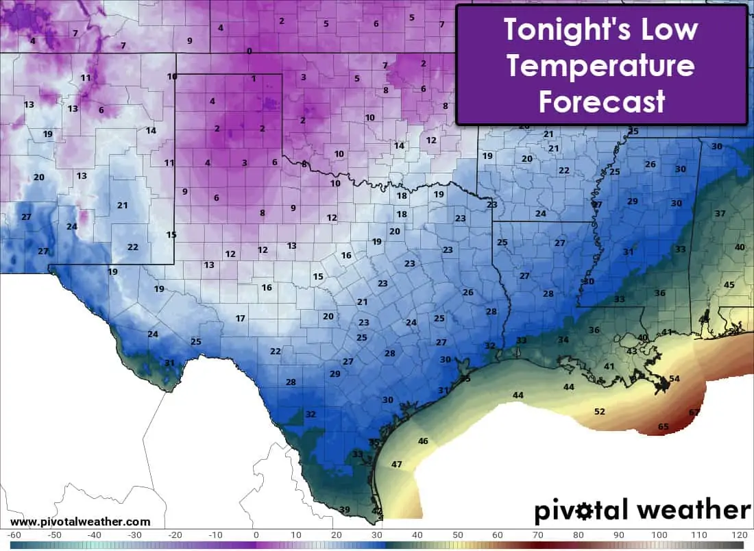
Tonight’s Low-Temperature Forecast
Temperatures will fall below freezing tonight for a vast majority of Texas. Any accumulations that meltdown into slush or water today will re-freeze into ice tonight. Single-digit temperatures are forecast in the Texas Panhandle, West Texas, and Northwest Texas tonight. Texas’s remainder will remain comparatively warmer, with lows ‘only’ down into the teens and twenties.
One last Winter Storm Thursday Morning
Final winter weather event tonight and Thursday…
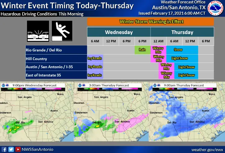
Finally, there was only one. We have one final chance of accumulating winter precipitation late tonight and on Thursday. This event will be concentrated across the Permian Basin, Concho Valley, Edwards Plateau, Central/South-Central Texas, into some of the Coastal Plains. For the northern half of Texas, you shouldn’t see more than a few stray flurries. I say we shouldn’t because we shouldn’t have had millions of folks without power this week, but we all know how that went.
Snow will be on the increase late tonight and could continue through Thursday afternoon. Temperatures tomorrow will be colder than today, with additional snow accumulations likely. This final system does look like it should mostly be a snowmaker, but sleet could mix in at times. Expect snow accumulations on all surfaces, including roadways. Some spots may pick up several more inches of snow on top of whatever is already on the ground. Austin, San Antonio, San Angelo, Midland, and Odessa could pick up a few inches of snow tomorrow. A heavier snow band may set up around Del Rio eastward toward the San Antonio metro – with significant snowfall accumulations (3″-5+”) possible in localized spots. We’ll be winding down late Thursday afternoon, but lighter snow may continue into the evening hours.
The warming trend begins on Friday.
Friday morning will be below freezing across all of Texas. Temperatures into the single digits or teens are expected well into the Edwards Plateau, Hill Country, Central Texas, and Brazos Valley. Anything that manages to melt on Thursday will turn back into a solid sheet of ice by Friday morning. That includes slush or grooves in the snow where vehicles have driven. Finally, after a historic week of weather and impacts in Texas, we’ll be done with the winter weather. Temperatures start warming on Thursday, and that trend will continue nicely this weekend. By Saturday afternoon, temperatures will make it up into the 40s, 50s, 60s, and even a few 70s. Remember – until the snowpack melts off – expect those with snow to be sharply colder during the day and night compared to those without snow. Temperatures maps are going to look pretty weird the next few days.


0 Comments