
One busy day of winter weather down, and it looks like we have another three potential winter weather events in store over the next five days. Mama Nature is overdoing it, and it looks like this will be a winter to remember. Not only will we have multiple opportunities for accumulating winter precipitation, but some of the coldest air in decades will be in place as that precipitation falls—a scarce combination for us southerners. Let’s start with a few key messages before diving into the nitty-gritty details.
Key Messages
The combination of both cold temperatures and winter precipitation has the potential to significantly impact life and property across a majority of Texas this weekend and at least through the first half of next week.
- Travel will be impacted by hazardous road conditions from a major winter storm – perhaps lasting several days in areas that receive significant snow and ice accumulations. Localized disruptions are already ongoing in the Permian Basin, Concho Valley, Hill Country, and Central Texas. Far more widespread travel disruptions are anticipated on Sunday, Monday, and Tuesday. Another winter storm may result in disruptions continuing/worsening again on Wednesday and Thursday across portions of Texas.
- Sporadic power outages will be a possibility where we have significant amounts of ice build-up on powerlines and/or trees. Some power outages are also possible due to the extreme cold and high energy demand.
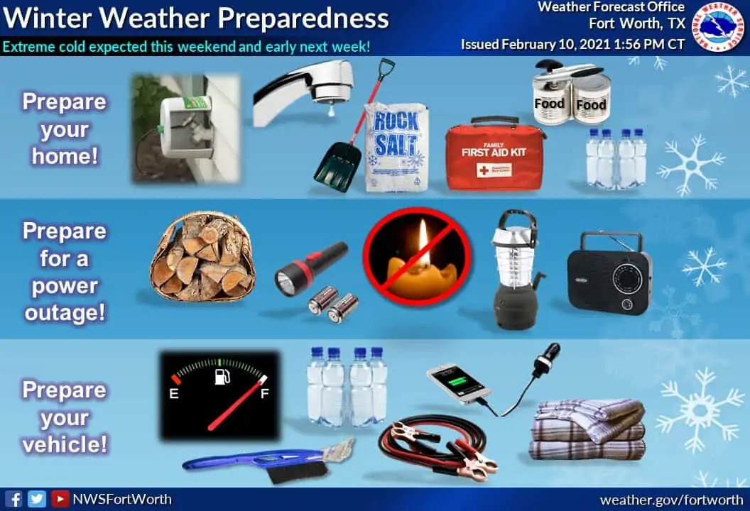
- Pipes (including sprinkler systems) will be subject to bursting if not adequately insulated. Hypothermia may be a possibility for those exposed and not dressed accordingly, especially from Sunday through Tuesday. Residents should use the next couple of days to prepare before the coldest air arrives. Remember the 4 P`s: pipes, people, pets, and plants. Also, be aware of space heater dangers if not properly place/used.
- There are now three winter weather events possible over the next five days. The first is a quick-hitter on Saturday afternoon and evening. A major winter storm is likely late Saturday in the west, spreading east on Sunday across much of Texas and departing on Monday. There is increasing potential for another impactful winter storm on Wednesday and Thursday across Texas’s eastern two-thirds.
- Texas Road Conditions can always be found at DriveTexas.org.
- You can receive our latest weather blog discussions with our free mobile app (click here to download)
Today and Tonight
We’ll need to watch for freezing drizzle tonight where temperatures are below freezing. That being said, we’re going to focus this post on the upcoming winter storms. We’ll be watching for drizzle potential and will post updates as needed throughout the day.
Storm #1 (Saturday)
There is increasing concern about a quick-hitting storm system tomorrow afternoon and tomorrow evening. This first storm could bring winter precipitation to parts of the Concho Valley, Hill Country, Central Texas, North Texas, Brazos Valley, and East Texas. Precipitation types are still a bit uncertain, but it looks like this could be freezing rain and/or sleet event for most of the aforementioned regions. Snow would be more likely if precipitation occurs along and north of Interstate 20 – but freezing drizzle is a worry if heavier precipitation stays south of Interstate 20. In other words, roads could go downhill by tomorrow evening.
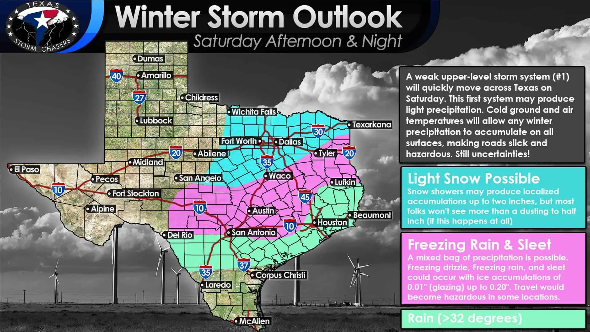
Confidence is highest (relatively) in freezing rain and/or sleet occurring for a few hours tomorrow evening in parts of the Concho Valley, Hill Country, Central Texas, Brazos Valley, up into East Texas. The southern delineation of the freezing rain versus rain is the estimated position of the freezing line. If surface temperatures end up being a few degrees lower than expected, there could be freezing rain in places like San Antonio and Houston tomorrow night. As it stands, folks should be ready for roads to be in bad shape tomorrow night, where we’ve got pink highlighted on the map. Ice accumulations could range from a trace (0.01″) up to two-tenths of an inch (0.20″).
Some of these locations already have a fair bit of ice accumulated on elevated surfaces, so any more on top would increase the chance for spotty power outages and tree damage. It only takes glazing of ice on surfaces to turn bridges, overpasses, and even some roads into skating rinks. We saw the horrific results of freezing drizzle and freezing rain yesterday. Don’t underestimate the freezing rain. If we can get precipitation farther north into the Big Country and North Texas, it would likely fall as snow. While widespread accumulations don’t seem probable tomorrow evening, some folks may end up picking up a dusting to two inches under any snow showers. We’ll get higher-resolution weather model data today that should help us refine the potential for winter mischief tomorrow and tomorrow night.
Major Winter Storm (#2)
Let me preface the discussion for our upcoming winter headaches by reminding readers that we’ll have a very cold airmass in place on Sunday and Monday. Typically our temperatures are right around freezing (32 degrees) when winter precipitation is falling. That won’t be the case for most of this upcoming week, with temperatures well below freezing. That’ll only increase impacts on travel and result in drier, powdery snow. That drier snow will get blown around by gusty north winds as another reinforcing arctic blast arrives on Monday.
Near blizzard conditions are possible, along with snowdrifts. The storm system responsible for Sunday and Monday’s headaches will be moving onto the West Coast of the United States tonight. Once it is onshore, we’ll be able to get weather balloons up and get a better grasp on just exactly how the storm system will behave. Forecast changes are still probable, including accumulation totals and the exact precipitation types and locations. Some snow totals may need to be increased in future forecasts.
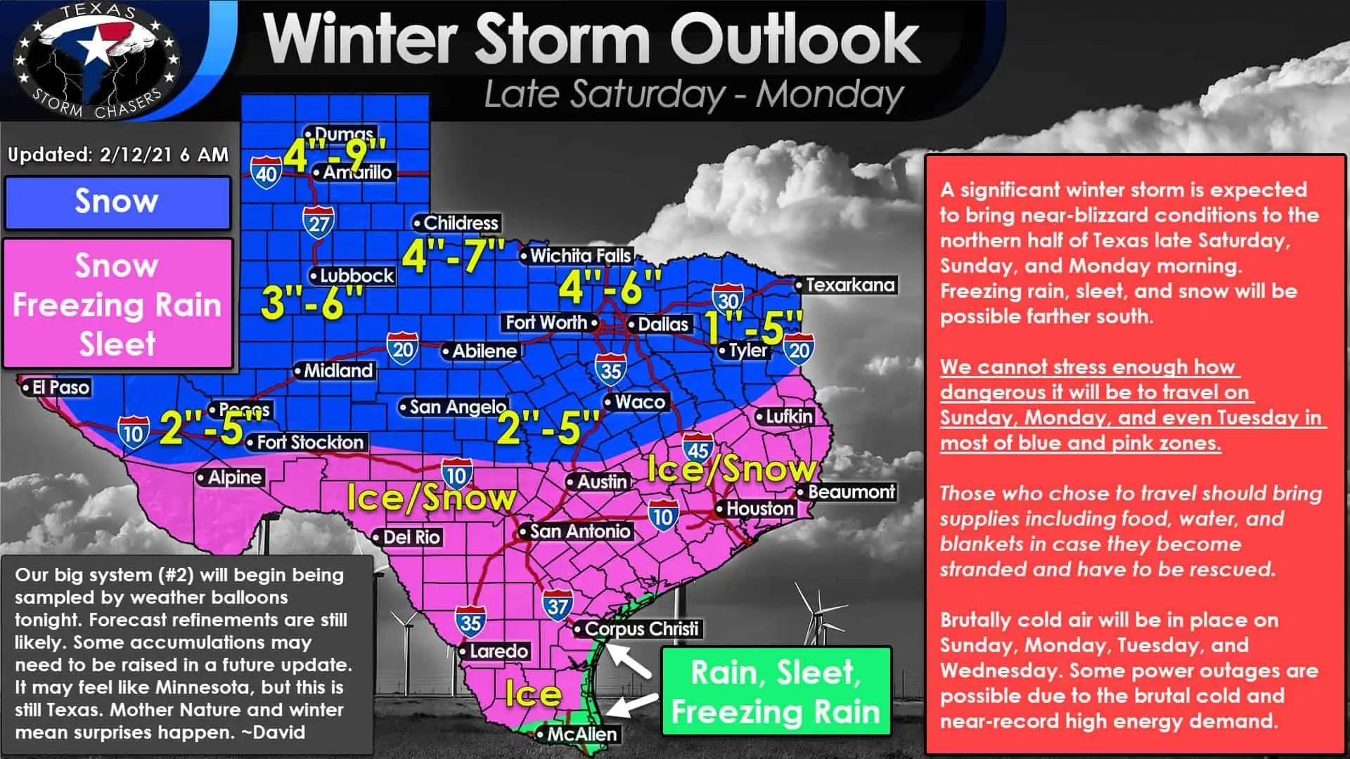
We generally expect snow to be the primary precipitation type across the northern half of Texas. Two to five inches of snow accumulation will be possible in the Permian Basin, Concho Valley, and Central Texas. Three to six inches of snow is possible from West Texas eastward through the Big Country, Texoma, and North Texas from D/FW north. Four to nine inches of snow is currently expected across Northwest Texas and in the Texas Panhandle.
A mixture of snow, sleet, and freezing rain is forecast across the Edwards Plateau, Central Texas, South-Central Texas, the Brazos Valley, East Texas, Southeast Texas, Coastal Plains, Middle Texas Coast, and well into South Texas. Some will see mostly snow, some will see a mixture of sleet, freezing rain, and snow, while some may end up seeing freezing rain and sleet. That was a complicated way of saying we’re going to have a trifecta of winter precipitation types. Even inside twenty-four hours, it is difficult and usually foolish to get too specific on those precip-types.
Whatever falls will likely accumulate as surface temperatures will be in the twenties. Freezing Rain and Sleet accumulations, known as only ‘ice’ from here on, will likely result in difficult to near-impossible travel across the aforementioned regions. Yes, that includes Austin, San Antonio, College Station, Lufkin, Houston, Beaumont, Laredo, and even Corpus Christi. We think it’ll be mostly rain along the immediate South Texas coast and in the Rio Grande Valley. However, I would also bet on there being some sleet mixing in at times. If surface temperatures dip below freezing, rain becomes freezing rain, and ice starts accumulating on elevated surfaces.
These broad accumulation numbers will be refined as we get closer. However, considering we’re talking about a winter storm still days away in Texas, I think most will understand that nothing is written in stone. Usually, we wouldn’t even be putting out such accumulation estimates yet, but this isn’t exactly a typical Texas winter storm. This forecast is still likely to change some, and I’ve tried to be a bit conservative with the snow accumulation totals. Some weather models produce much more snow than I’ve overlaid on our graphic, but others are drier.
Timing
Light to moderate snow may be underway by Saturday afternoon in the Texas Panhandle. Snow will increase in coverage Saturday evening across the western third of Texas. Precipitation will increase in scope and intensity as it quickly moves east on Sunday across Texas. Weather models have tried speeding the system up, so this may end up being mostly a Saturday Night (west) and Sunday (everyone else) event. The fastest weather model guidance has precipitation ending across eastern Texas before sunrise on Monday.
There’s still an opportunity for this to shift ahead or back around eight hours. Once the storm system gets into our weather balloon network later today, we should better handle the particular timing. While precipitation may stop falling by Monday morning, brutally cold air will filter behind the departing winter storm. Temperatures will not rise above freezing for at least a couple of days in most locations. Accumulations will not melt for a while, and whatever accumulates on roads will stay there until plowed or otherwise treated. We anticipate hazardous travel conditions will persist through Monday, Tuesday, and perhaps longer. Of-course we also now have the added complications of another winter storm potentially arriving on Wednesday.
Storm #3
Extended range weather model guidance has become better aligned in showing yet another winter storm impacting parts of Texas next week. This third winter storm would occur on Wednesday and/or Thursday. I don’t have time to make some graphics for this. Still, it could accumulate winter precipitation to a large chunk of Texas again. Let’s get past the first two winter storms before we even ponder the third. Still, at a minimum, it would prolong our stretch of arctic air and hamper recovery efforts from the Sunday/Monday event.
Temperature Forecast
A lot has been said about the upcoming cold snap. It will be dangerous, and it will be the coldest several Texas cities have been in several years or decades. I’ll the graphics show the rest, but when you have temperatures trying to dip below zero in the D/FW Metroplex, you’re asking to burst pipes. It will be frigid across all of Texas by Tuesday morning.


0 Comments