
An eclipse for lunch and severe storms by dinner? Welcome to Texas weather in April. That appears to be on the agenda for Monday. We still have several days of more excellent weather to enjoy, though. Dry weather is expected to continue through most of the weekend. We may see some light showers Saturday evening into Sunday morning across the eastern half of Texas.
There is not much to write home about, and the threat of more rowdy storms has shifted north of the Red River. If you want wind, you’ll get plenty of that. We’ll experience wind gusts over 40 MPH at times through the weekend. Blowing dust and critical wildfire danger is expected to occur over the western third of Texas on Friday and Saturday, posing a potential risk to outdoor activities.

Clouds arrive Monday Morning ahead of the Eclipse.
Prepare for a change in weather as southeasterly winds start bringing moisture back into Texas from the Gulf of Mexico Sunday night and into Monday morning. This moisture advection will lead to the rapid development of low clouds across the southern half of Texas. An active upper-level Jetstream overhead will result in a nearly complete layer of cirrus aloft. Unfortunately, viewing conditions for the eclipse in Texas on Monday are not expected to be favorable.
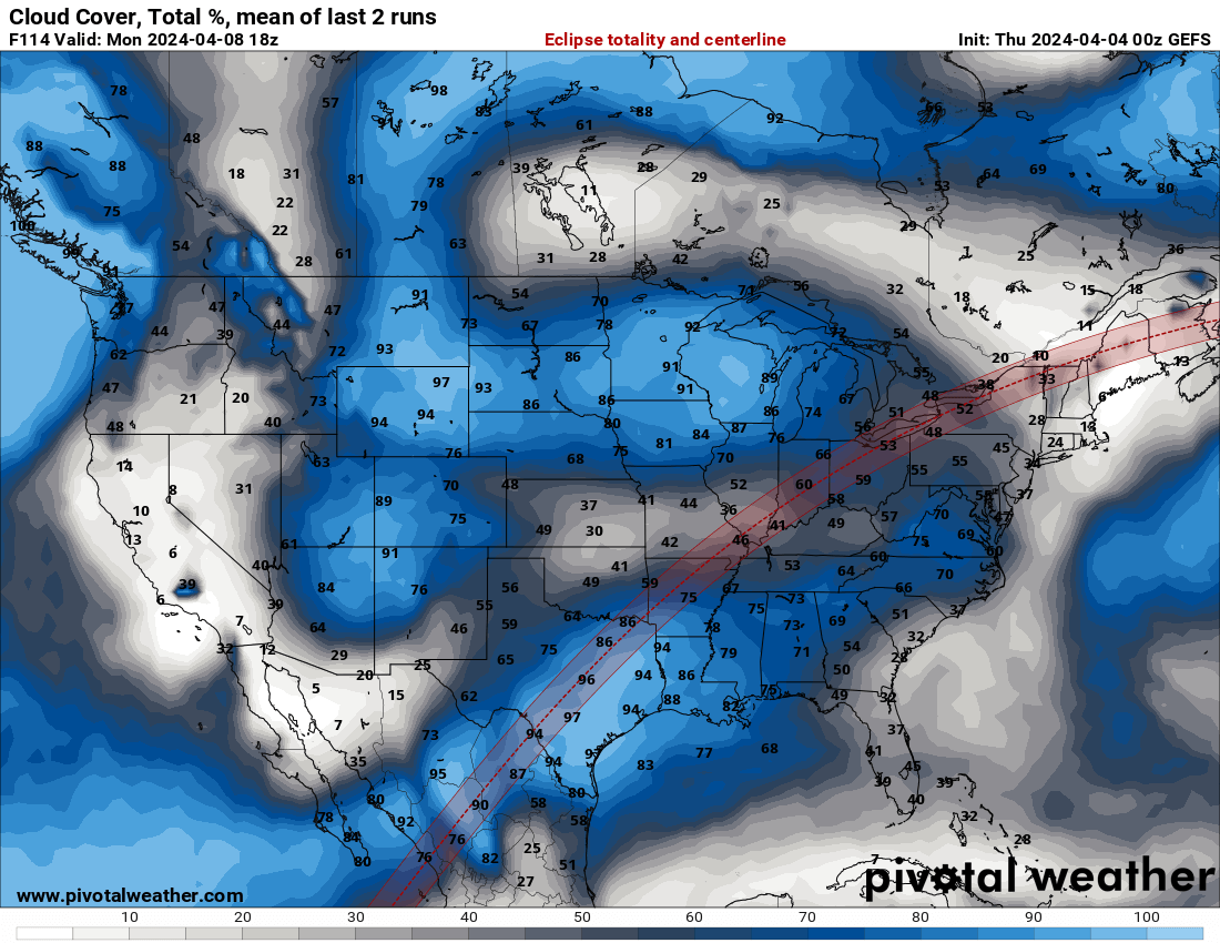
There is a seventy to ninety-five percent chance of cloud cover as the Eclipse passes over Texas on Monday. The highest (relative, and not super great) chance for thinner upper-level clouds will be in Northeast Texas. Dense low-level overcast will be quickly spreading north on Monday.
The eclipse’s effects will remain quite clear, with the relative darkness becoming even more pronounced due to the cloudy skies. The day will turn to night, and the cloud cover will act as a blanket. Temperatures may drop one to two degrees during the eclipse’s peak, but we won’t see a substantial drop-off as would have been the case if skies were clear. We’re hopeful for some timing improvements and a chance for some breaks in the clouds on Monday, but that’s not looking likely.
Severe Storms Monday and Tuesday

If Monday’s eclipse wasn’t enough excitement for one day, Mother Nature has decided to add a dash of drama with the potential for severe thunderstorms. The storm threat looks to begin a few hours after the eclipse in Texoma, North Texas, Northeast Texas, and East Texas. Some storms could be severe, with large hail and damaging winds.

They may form into a cluster that moves toward Louisiana early Tuesday. We’ll be experiencing more stormy weather Tuesday afternoon and evening over the same regions – with Central Texas, the Brazos Valley, and Southeast Texas joining in. Some storms will likely be severe, with at least the threat of large hail and damaging winds. Storms may become widespread Tuesday night into Wednesday across the southeastern half of Texas – with heavy rainfall possible. If you’ve ever wondered how Baldy went bald in his twenties, this is the kind of weather that could do it.
My FREE & AWESOME weather app for radar/alerts/more: https://texasweather.app/
The 24/7 Texas weather tracker & music: https://www.youtube.com/watch?v=lNZuPEWS5AI&t=0s
Storm chaser videos: https://www.youtube.com/texasstormchasers
Facebook: https://www.facebook.com/TxStormChasers
TikTok: https://www.tiktok.com/@texasstormchasers
X (Twitter): https://twitter.com/TxStormChasers


What happened to the video?
Great!!!!!
Great!!!!!