
All eyes are on the tropics. The National Hurricane Center has given Invest 99L a 90% chance of becoming a tropical depression within the next 48 hours. Honestly, I believe the system may be considered a ‘tropical depression’ by lunchtime. Satellite imagery has shown a general uptick in thunderstorm organization overnight. Once a defined low-level center has formed, the system will meet the criteria designated a tropical cyclone.
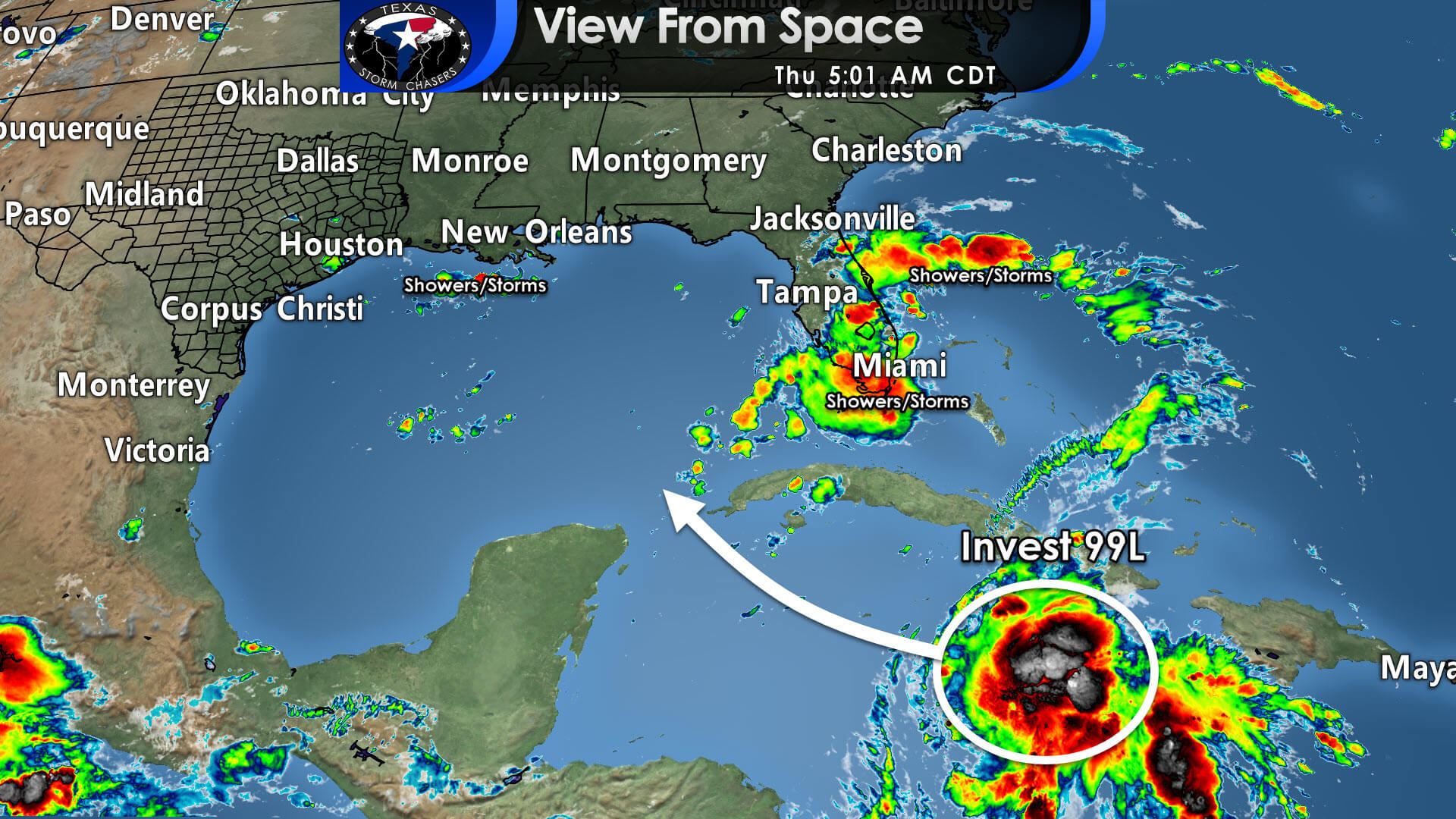
Downright hot sea-surface temperatures and weak upper-level winds favor at least gradual intensification. Once the system becomes a tropical storm, which may happen by tonight, it will likely be named ‘Ida.’ Intensification is likely as the system moves into and across the western Gulf of Mexico this weekend. What will likely be ‘Ida’ is expected to become a hurricane, perhaps a very intense one before it makes landfall late this weekend or early next week.
So, where’s the darn thing going?
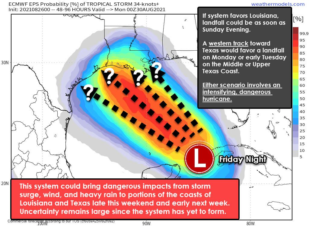
Until the National Hurricane Center starts issuing forecasts on 99L/Ida, I have to use a ‘custom made’ graphic. The background data comes from the European Weather Model’s ensemble system. Please understand the weather models have been showing significant shifts ‘west’ and ‘east’ with each subsequent weather model run. I’ll explain some of the uncertainties in the long-range track in a bit.
Live by the weather models… die by the weather models.
Overnight weather model data generally favored a corridor from the Upper Texas Coast and the Golden Triangle east into South-Central Louisiana for landfall. We are four days out from a potential landfall, and we don’t even have a formed system just yet. Both factors mean shifts will be in the track forecast, and I strongly encourage readers not to get baited into weather model mischief.
Yes, they can be useful for trends, but one must also remember that a 20-mile shift in the next six hours could mean a 300-500 mile shift by the time we get to Sunday Night. Tropical systems are not easy to forecast, and we’re dealing with one that hasn’t even technically formed yet. We are going to be purposely vague in the possible threat zones. I don’t want to get honed in on a smaller region only to have to shift it in subsequent forecasts. I’ll explain some of the logic behind steering currents in a bit.
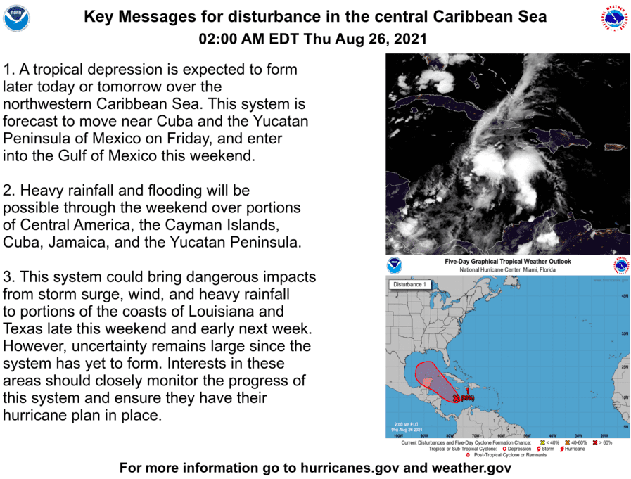
We should have a tropical storm or hurricane Ida crossing from the Caribbean into the southern Gulf of Mexico – perhaps bringing impacts to far western Cuba by Friday night. The system should be moving west/northwest on Saturday and into Sunday. Intensification is likely and rapid intensification is certainly a possibility. The Gulf of Mexico’s waters are in the upper 80s, and that is kerosene to hurricanes. Many ingredients look favorable for significant intensification up until the system’s landfall.
All of that was a fancy way of saying we could have a significant, dangerous hurricane approaching the northern Gulf Coast Sunday Night or Monday. If the system takes a more ‘easterly’ track, it will probably be moving more quickly and arrive somewhere on the Louisiana coastline Sunday evening or Sunday night. A more westerly track would favor the Middle or Upper Texas Coast on Monday. Overnight weather model data did latch more onto the ‘easterly’ track, but some data still holds west too and impacts the Upper Texas Coast on Monday.
Main factors determining the longer-range track
Two main factors are dictating the future track of probable Ida. The first is an area of high pressure across the eastern United States. This weekend, the clockwise motion around the high pressure will help guide the system into the western or central Gulf of Mexico. It will greatly factor into the landfall location. If the high pressure is stronger or further west than weather models anticipate, the hurricane will make landfall further west.
Likewise, if the high pressure is weaker or further east than weather models predict, the hurricane will likely miss Texas and visit our friends in Louisiana or Mississippi. The second main factor is where the system eventually develops in the short term. If the system develops further north in the Caribbean, that would increase the likelihood it takes the ‘easterly’ track. That might be what is happening this morning, but we’ll see what this morning’s weather model data shows. There is still too much uncertainty to put much faith in any ‘landfall’ locations just yet. We dealt with the same problem last year with Hurricane Laura.
Potential Impacts
After landfall, the hurricane is expected to slow as it moves inland. A considerable inland heavy rain and flooding threat is expected near the system’s track. If landfall occurs in South-Central Louisiana, we may not see much at all in Texas.
A landfall in Southwestern Lousiana, much like Laura last year, would result in strong winds, heavy rain, and a flooding threat for the Golden Triangle, East Texas, and the Ark-La-Tex. Some surge would probably occur on the Upper Texas Coast, east of Galveston.
If landfall ends up occurring on the Upper Texas Coast – well, we’d be facing a dangerous storm surge, hurricane-force winds, torrential rains well inland, and a tornado threat in the northeastern quadrant of the system. While overnight trends do tend to favor a Louisiana landfall, it remains way too close to say we’re not going to have problems on the Upper Texas Coast.
Review your Hurricane Plan & Supply Kit
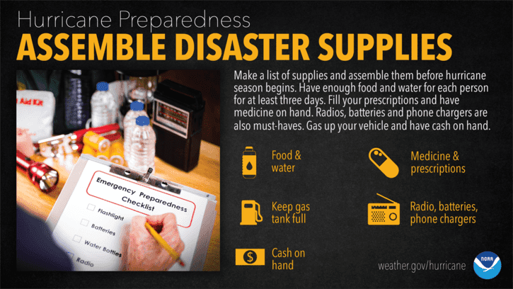
I am hopeful we’ll have a much better idea by this evening or early Friday of the system’s eventual track – or if we can start ‘downgrading’ our concern for the Upper Texas Coast. Those with interests on the Middle Texas Coast, Upper Texas Coast, and Louisiana should review their hurricane plans, supply kit and vigilantly monitor weather forecasts.


0 Comments