
Changes in the weather are on the horizon as the upper level heat ridge breaks down. The result of the ridge breaking down will be a weak flow aloft with a cool front moving south into Texas this weekend. That front will become stationary over the weekend and play a role in rain chances into next week. Temperatures north of the cool front will be ten to twenty degrees lower than what we experienced this week. As usual the most pronounced temperature drops will be located in northern sections of the state. We’re anticipating a dip back to average or even below-average temperatures for the northern/western half of Texas this weekend. The first impacts of the cool front will be felt tonight as precipitation chances increase across the Texas Panhandle.
Today and Tonight
High temperatures will be above-average once again today across the eastern two-thirds of Texas. Heat advisories are in place from about 50 miles west of Interstate 35 all the way east into Arkansas and Louisiana. Heat advisories are issued when afternoon heat index values are forecast to be above 105 degrees and low temperatures are not expected to drop below 78-80 degrees during the night. High temperatures themselves will be in the upper 90s to mid 100s across the eastern two-thirds of Texas this afternoon. In Far West Texas and the Texas Panhandle temperatures will be about ten degrees cooler than further east thanks to increased clouds.
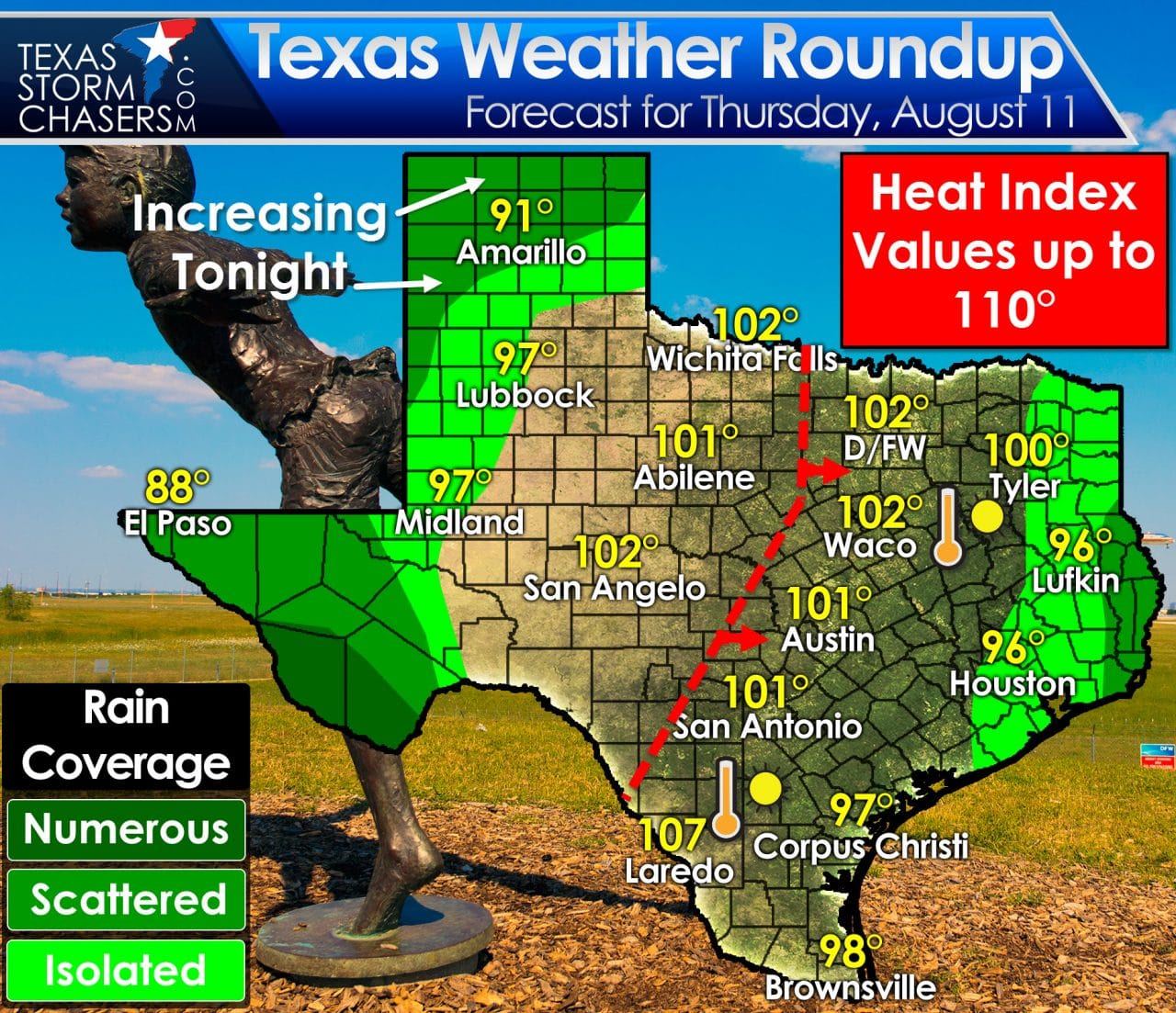
There will be three separate regions with possible rain chances today and tonight. The first is across East and Southeast Texas where typical summertime moisture will allow for isolated to scattered afternoon showers. Some of the activity could produce locally heavy rain. The highest concentration of activity is expected to be on the Louisiana border. Far West Texas and the Big Bend will see scattered to numerous showers and thunderstorms today and tonight as the monsoon continues in earnest. Locally heavy rains are possible and flash flood watches are in effect for Far West Texas and the Big Bend. Several inches of rain may fall by the end of the weekend – increasing the possibility of flash flooding as time goes on.
Finally we have increasing thunderstorm chances this afternoon and tonight across the Texas Panhandle and West Texas. The much anticipated cool front will sag south into the Panhandle tonight. As the front interacts with an anomalously moist atmosphere an increase in convection is expected. Some storms may be strong tonight with localized gusty winds and heavy rains. Widespread flash flooding is not forecast to be an issue tonight, but hopefully we can get some good rains. Precipitation chances increase further during the day Friday.
Increasing Rain Chances Friday through Monday
As the front slowly moves south on Saturday the chance for rain will likewise increase across Northwest Texas, the Permian Basin, Big Country, and North Texas. We’re not talking about a complete and utter wash-out, but scattered thunderstorms are a good bet. The highest concentration of storms will be near the front – which will be influenced by previous convection. That is to say the front’s eventual position this weekend and into next week will depend on how far south (or not) storms push it. Some locations could pick up one to three inches of rain by the time the weekend concludes. A localized flooding threat may develop in proximity to the front where training thunderstorms are a possibility.
Temperatures Tending Down This Weekend into Early Next Week
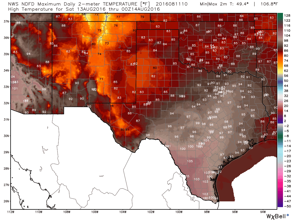
Saturday’s High Temperature Forecast
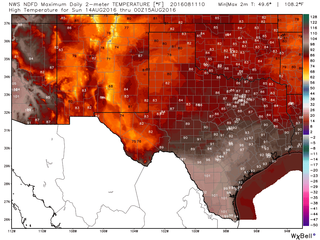
Sunday’s High Temperature Forecast
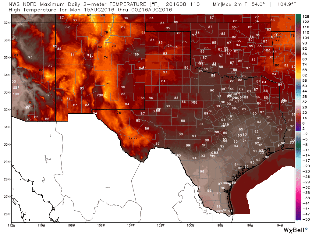
Monday’s High Temperature Forecast
Another benefit of the cool front and associated rains will be the clouds. More clouds mean less sun and cooler temperatures. We’re still in August and that means temperatures won’t be falling back into the 60s. However, we should see temperatures several degrees lower than the previous few weeks. Some folks will likely remain below 90 degrees all weekend – below average temperatures for August. The cooler weather will continue into early next week with associated rain chances. High temperatures look to remain in the 80s to middle 90s for much of Texas.


0 Comments