
Fifteen days until Thanksgiving and forty-five days until Christmas. While we won’t be dealing with any winter weather today, one can hope we might get a little snow before too much longer. Today’s discussion will revolve around a different type of frozen precipitation – the kind that tends to leave dents in objects. While widespread severe weather is not expected later today, we will likely have a few rowdy storms to keep an eye on.
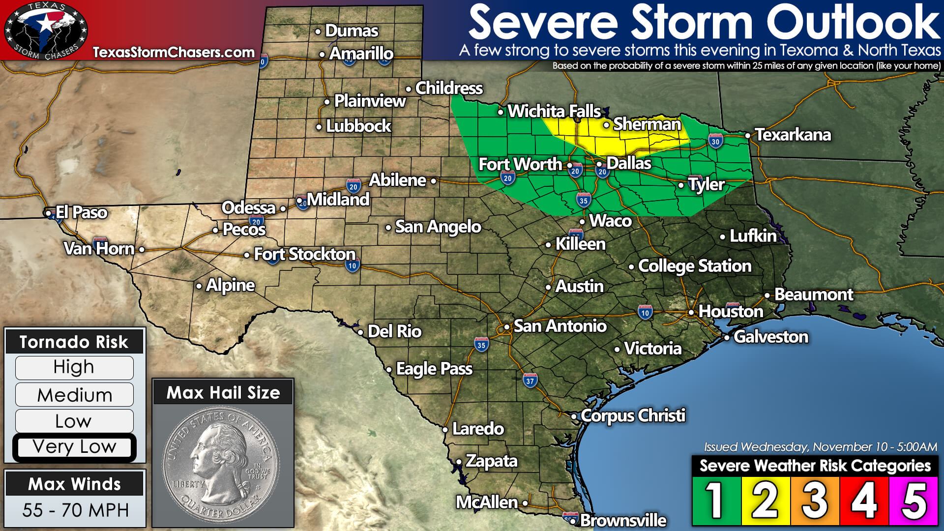
A few severe storms are possible across Texoma and North Texas – including the D/FW Metroplex. The strongest storms may produce large hail, localized damaging wind gusts, and perhaps a brief tornado. A majority of storms tonight will behave themselves. Our friends at the Storm Prediction Center have highlighted Central Oklahoma (including OKC) south to the northern D/FW Metroplex for scattered severe storms this evening.
A more isolated risk for large hail and strong winds runs from Wichita Falls to Eastland to Waco to Jacksonville to Marshall. There is a very low threat for a brief tornado, but more likely than not, strong outflow winds and some pocket-change size hail will be our primary issues.

Simulated weather model radar for this evening and overnight. Strong storms are expected to form along a cool front from Oklahoma City to near Wichita Falls around dinner-time. Those storms will move southeast, probably creating a broken squall line this evening. That squall line will move southeast overnight – with a few stronger storms possible through midnight in Texoma, North Texas, and Northeast Texas. Storms should be below severe limits as they move into the Brazos Valley and Southeast Texas Thursday morning.
Our primary focus for severe weather potential will be the initial thunderstorm development this evening. You may notice the HRRR model (shown above) depicts an initial discrete storm mode. That’s when we’ll have to watch for some large hail and perhaps a brief tornado. Instability values and surface dewpoints aren’t overly impressive. Still, as is typical for the cool season, we have plenty of wind shear aloft. Once storms become linear (a broken squall line), they’ll likely produce outflow winds of 35 to 55 miles per hour. A few higher gusts are probable, mainly before midnight in Texoma and North Texas.
We’ll be keeping an eye on a few different parameters throughout the day. Just how much instability will be available for storms this evening? Where exactly are things set up (sometimes they’re a bit further west)? Finally, where (or if) will the ingredients come together to support a brief period of supercelluar storm mode (looking like Southern Oklahoma to the Texas side of the Red River). Today certainly isn’t a robust or widespread severe weather event. Still, we all know it only takes one nasty storm to cause problems – especially if it comes down your street!
You can always view the latest severe weather outlooks from the Storm Prediction Center here on our website. The ‘Day 1 outlooks’ are updated at 7 AM, 10:30 AM, 2 PM, and 7 PM CST. Yup, they’re an hour earlier, thanks to reverting to standard time versus daylight saving time.
Our team will be out chasing today, while I’ll likely remain in the studio’ to provide any digital weather updates tonight. One of these days, I’ll get back out there to yell random hoopla and narrate the rotating water vapor! Check back around dinner-time for live video feeds from our chasers on our website and our YouTube channel.


0 Comments