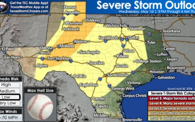
New thunderstorms have developed across the BIg Country and North Texas over the last hour. These storms are generally rooted in a line from near Breckenridge to Granbury to Waxahachie to Canton – moving north at 20 to 30 MPH. The strongest storms may produce small hail, frequent lightning, and heavy rain. I can’t rule out a storm with larger hail over the next hour.
A severe storm with hail and damaging winds is moving into the Shreveport metro now from Harrison County in East Texas. This storm probably produced high wind and some hail from Marshall to Leigh. By the time you read this the storm should be out of Texas, but the fact it was able to produce damaging winds – even with a more stable layer of air near the surface, probably isn’t a good omen for storms later on today.
A line of strong/severe storms in the Concho Valley from Barnhart to Sterling City is moving east/northeast around 30 MPH. These have organized over the last 45 minutes and could bring hail, high wind, and flooding to San Angelo (Tom Green County) by 6:30 AM. The threat for tornadoes is very low with this activity since they’re elevated above a stable layer of air near the surface (north of the warm front).
A supercell thunderstorm is in western Kinney county in the Edwards Plateau. This storm is in an environment supportive of significant severe weather, including tornadoes. The storm itself has organized over the last thirty minutes and now has an impressive hail core. I wouldn’t be surprised if it produced golfball to baseball size hail. Low-level rotation is weak, but a tornado threat could certainly develop as this storm moves east/northeast at 30 MPH. Those in Pinto and Brackettville should be ready to move to shelter if a tornado warning is issued.
Additional thunderstorms will develop later this morning into the afternoon. Our thoughts have not changed compared to the detailed update we provided a few hours ago. You can read that here. We’ll have a detailed forecast update on the late morning/afternoon storms around 8 AM.


0 Comments