
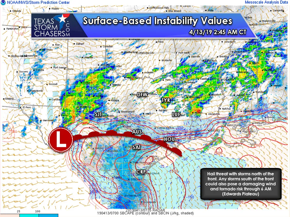
On a regional basis, we’re seeing a break from stronger storms in North Texas and East Texas compared to an hour or two ago. We continue to watch a supercell with very large hail passing south of Big Lake moving toward Irion and Tom Green counties. That storm seems to be *just* north of a surface warm front, but is still quite capable of producing damaging hail.
Our second area of interest is in the Edwards Plateau. We’ve seen a few storms try and pulse up over the last 30 minutes, but generally with only limited success. We’ve got a few storms around Junction with small hail and several showers/storms just west of Del Rio and Eagle Pass. It is those storms moving toward Del Rio and Eagle Pass that we’ll have to watch for signs of becoming supercelluar. A tornado watch is in effect for the Edwards Plateau through 9 AM.
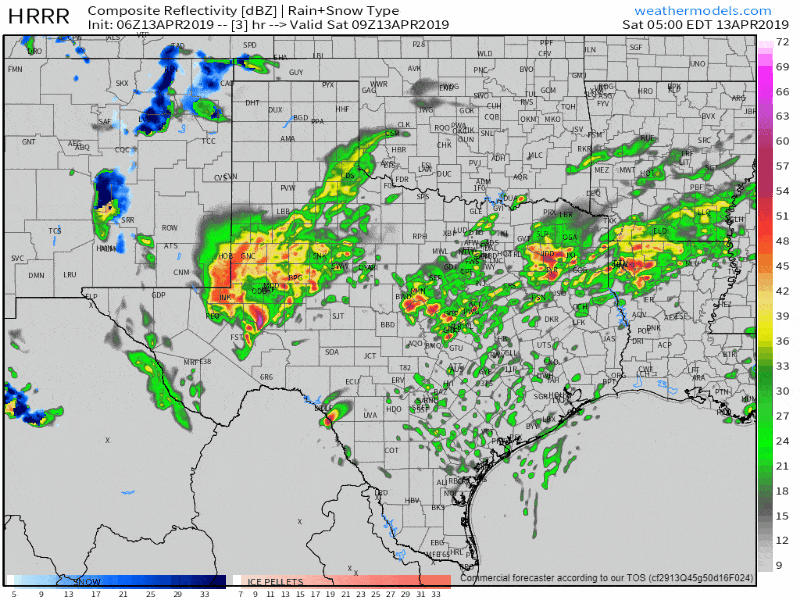
6Z HRRR simulated weather radar from 4 AM to 12 PM today (storms will continue beyond noon).
A third area to watch over the next few hours will be southern North Texas and Central Texas. Upper-level lift is increasing as evidenced by multiple small showers/storms developing over the last 30-45 minutes. We’ll likely see several new thunderstorms fire up in those regions over the next hour or two. Those storms will move north/northeast into North Texas and East Texas through 7 AM. Stronger storms could produce large hail. Localized wind gusts of 40 to 50 MPH are also possible. Tornadoes are unlikely given there is no surface-based instability that far north.
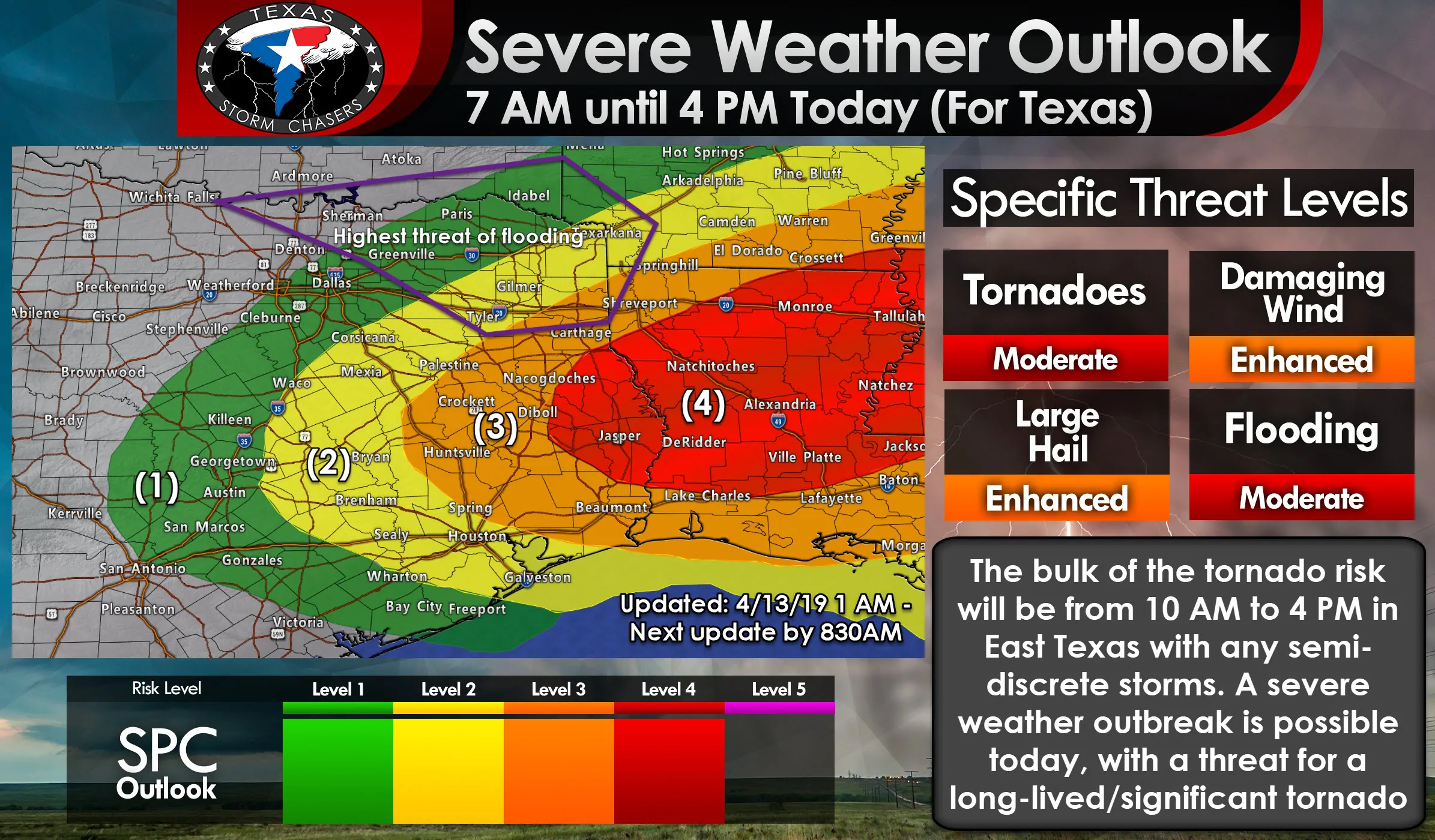
As we continue into the mid-morning hours the main ‘player’ for tornado risk will be the warm front. How far north that warm front makes it will dictate who all ends up having a risk of more significant severe weather by the late morning and early afternoon hours. If we have widespread showers/storms all morning we may have issues getting the front to move north all that quickly. As in, the front may not be able to make it as far north as we were thinking yesterday. That would place the highest risk for all modes of severe weather a bit farther south and in East Texas (south of Interstate 20). We’ll also have to see if we can get discrete/semi-discrete storms to fire up ahead of a broken line of storms.
The broken line of storms by the early afternoon will be moving east into East Texas with a threat of hail, damaging winds, and perhaps a few tornadoes (for those storms along and south of the warm front). Any discrete storms south of the warm front that can become supercells have the potential of producing a strong tornado, but that’s conditional on actually having open warm-sector development.


0 Comments