
No hazardous weather is expected today. Strong southerly winds and above-average temperatures will make it feel like April. Fire danger will be very high to critical across the Texas Panhandle, Northwest Texas, Big Country, Permian Basin, and Far Southwest Texas. Surface fuels remain dry and the gusty south winds will help any fires spread quickly. Our weather will quickly change beginning tonight and tomorrow.
Rain chances will begin on Monday and we’ll see them continue all week. An upper level storm system will take an anomalously far southerly track. It’ll actually dive well into northern Mexico. Climatological records indicate this happens once every five to ten years in the month of March. Copious amounts of moisture will advect northward from the Gulf of Mexico. That process is already underway as noted by the strong southerly winds today. It won’t be raining in one location all week. Several distinct rounds of precipitation are expected over the coming days. Tuesday and Wednesday look like the wettest two days out of this event with fairly widespread precipitation possible.
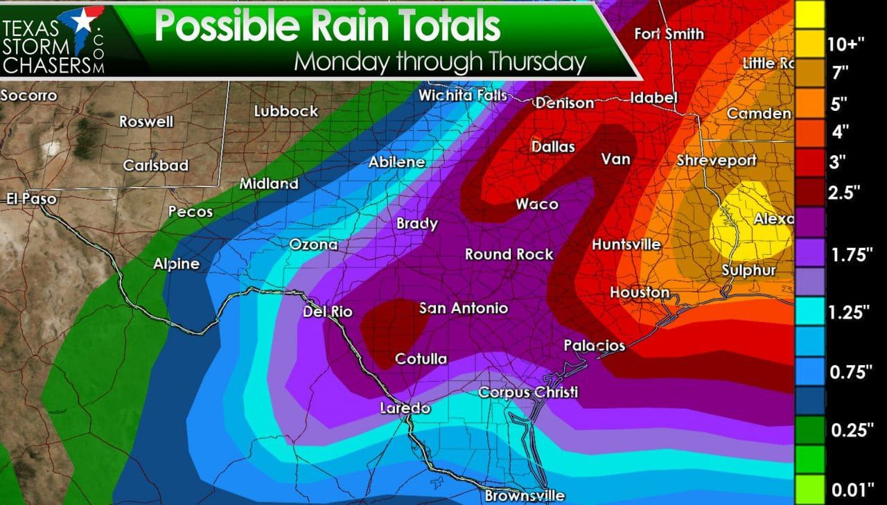
Any drought conditions that have developed across the eastern half of Texas are likely to be erased over the next couple of days. Widespread rainfall totals between 1 and 3 inches are expected across the Rio Grande Valley, South Texas, Hill Country, South-Central Texas, Central Texas, and the Brazos Valley. Rainfall accumulations of 2 to 5 inches will be possible across North Texas, Northeast Texas, East Texas, and Southeast Texas. Local amounts across East Texas and Southeast Texas could exceed 6 to 9 inches. Widespread flash flooding is not expected since most rain should fall over a prolonged period. Soil conditions and most rivers are also able to handle a couple inches of rain. If we were to see localized issues with flooding they would develop Tuesday Night and on Wednesday across the eastern third of Texas. River flooding and rises on lakes are certainly a distinct possibility by Wednesday-Friday. These rainfall forecasts are generalized with the expectation of varying amounts over a local area.
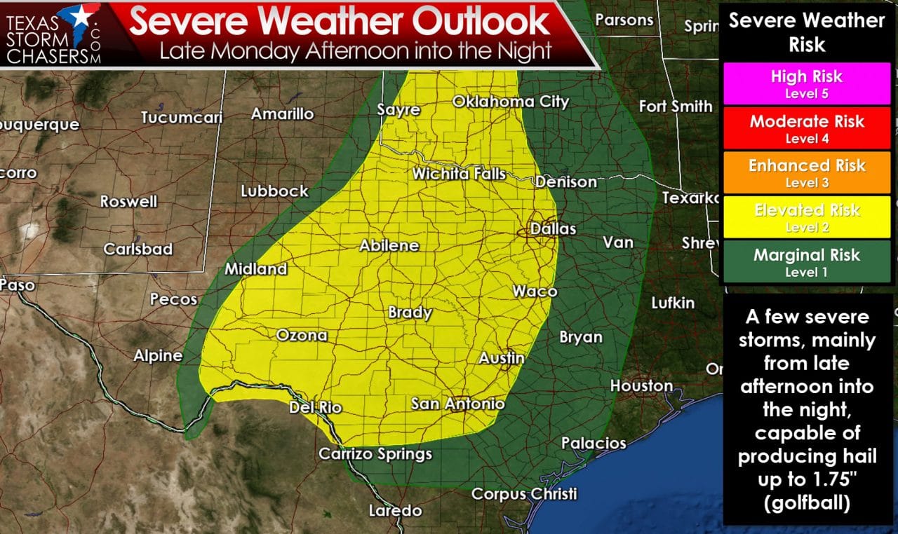
A few severe thunderstorms are possible during the late afternoon and nighttime hours on Monday. A cap is expected to keep a lid on thunderstorm development for much of the day Monday. A couple thunderstorms may fire up in North Texas and Central Texas around dinner-time on Monday. Should those storms develop they would be elevated above the cap. The elevated nature of the storms would keep the tornado threat very low along with the risk for stronger wind gusts. Large hail would be the primary threat.
Thunderstorms may develop in northern Mexico tomorrow afternoon. Should that development occur it’s possible those storms could move into Southwest Texas around Del Rio early Monday evening. The storms would probably be supercells with a large hail risk.
Finally the most likely scenario is thunderstorm development in Northwest Texas south into the Permian Basin late Monday into the predawn hours Tuesday. Those storms would be elevated with the strongest capable of producing hail up to the size of golfballs. They would likely move northeast into Oklahoma by the mid-morning hours Tuesday.
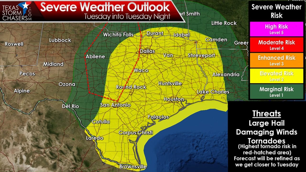
The stage may be coming together for a more concerning severe weather threat for Tuesday. The atmosphere will become very unstable – especially considering it’s only early March. The atmosphere doesn’t read nor does it abide by a calendar. Winds in the middle and upper levels of the atmosphere will be screaming out of the southwest. Winds may increase in the lower-levels during the afternoon hours as a low-level jet becomes established. You’ll certainly feel humid southeast winds on Tuesday. Unlike Monday there is concern a tornado risk will develop on Tuesday across western North Texas. Widespread thunderstorm development is likely by the evening hours from Oklahoma south to Mexico. Large hail and damaging winds will be possible – but the widespread nature of the rain/storms may help reduce the severe weather risk. Being three days out means forecast changes are expected. Please check back for forecast updates. As forecast confidence increases on Monday I wouldn’t be surprised to see a portion of the outlook area upgraded.
A few strong storms will be possible in Southeast Texas on Wednesday. We’ll deal with that issue once we get through Monday. The heavy rain threat will become an issue Tuesday Night and on Wednesday.


0 Comments