
I’ll keep this short and sweet since I’m attending a weather conference this morning. We expect no weather hazards this weekend. High temperatures will be warm in the 60s, 70s, and 80s. Low temperatures will range from the 40s to the low 60s tonight. They’ll be warmer Sunday night as moisture levels increase. Cloud cover will likely be on the increase tomorrow and especially by Sunday night.
After several weeks of relatively quiet weather we’re about to switch gears. An active weather period begins on Monday and looks to continue through at least Thursday. It won’t be raining the entire period as we’ll see several distinct rounds of precipitation.

Precipitable water values, a measure of measuring the amount of moisture contained in the atmosphere, will be near maximum values for March. That will help increase the potential for heavy rain – especially by Tuesday and Wednesday. The heaviest rain totals are expected to be along and east of Interstate 35 from the Red River south to Interstate 10. Widespread rain totals of 2 to 6 inches are a possibility. Some locations in Northeast Texas could receive over 6 inches of rain. Several weeks of dry weather will allow soils to absorb some rain before we have to deal with any flooding issues. Based on the current forecast rain totals I do believe we will see a flash flood/river flood threat develop in Northeast Texas and East Texas. If we can get 6 inches of rain to fall over a day versus a few hours that will help reduce the flash flooding risk somewhat. Those details will become more clear once we get closer to the event. It looks like we’ll see rivers return to flood stage in Northeast Texas and East Texas next week.
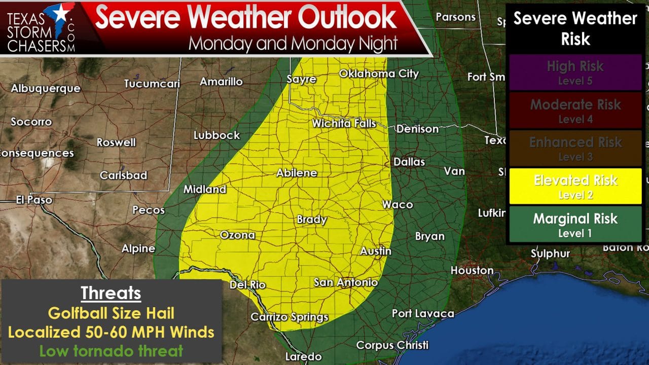
Severe thunderstorms will also be a threat this week. An isolated severe storm may occur Sunday evening across the eastern Texas Panhandle if the cap can break. Assuming the cap breaks one or two severe storms may produce hail for a few hours tomorrow evening. By Monday the threat for stronger thunderstorms will spread into Northwest Texas, the Big Country, Concho Valley, into North and Central Texas. Its looking like mainly a hail threat with the Monday and Monday Night storms. Spotty damaging wind gusts or even a brief tornado can’t be ruled out at this time.

The possibility of severe thunderstorms will continue on Tuesday across North Texas, Central Texas, Northeast Texas, East Texas, Southeast Texas, into South Texas. There are indications the atmosphere may become unusually unstable for so early in the ‘spring’ storm season. Combined with strong wind shear the stage could come together for a busy weather day. Details such as low-level wind shear, the amount of instablity available for thunderstorms, and any residual boundaries from previous storms won’t become known until we’re within 48 hours of the event. Nevertheless there is concern that a tornado threat may develop. I encourage you to check back for forecast updates as refinements are made. These threats are normal for the spring months. This is why its important to review your severe weather safety plans and know where to go. Don’t be scared – be prepared!


0 Comments