
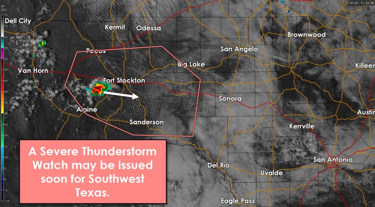
The Storm Prediction Center has issued a mesoscale discussion for Southwest Texas. That discussion indicates that a severe thunderstorm watch may be required in the next few hours. The first storm of the day has developed near Fort Stockton. It’s not severe at this time but conditions are becoming more favorable for organized thunderstorms. Southwest Texas is where we’ll be watching for thunderstorm development through early evening. Storms that develop there will move east towards South-Central Texas tonight. A complex or line of storms may form this evening and progress east. Large hail will be the primary threat with the strongest storms through early evening. Once they congeal into a line or complex the threat for localized damaging wind gusts will increase – especially in South-Central Texas including the San Antonio metro. The threat for a brief tornado is very low this evening but can’t be totally ruled out.
MESOSCALE DISCUSSION 0118
NWS STORM PREDICTION CENTER NORMAN OK
0318 PM CST MON FEB 22 2016
AREAS AFFECTED…SWRN TX
CONCERNING…SEVERE POTENTIAL…WATCH POSSIBLE
VALID 222118Z – 222345Z
PROBABILITY OF WATCH ISSUANCE…40 PERCENT
SUMMARY…THUNDERSTORMS ARE EXPECTED TO INCREASE OVER SWRN TX
THROUGH EARLY EVENING. SUPERCELL STRUCTURES WITH LARGE HAIL WILL BE
THE INITIAL PRIMARY THREAT AS ACTIVITY DEVELOPS EWD. TRENDS WILL
CONTINUE TO BE MONITORED FOR A POSSIBLE WW.
DISCUSSION…ELY POST FRONTAL LOW-LEVEL WINDS ARE MAINTAINING UPPER
40S TO NEAR 50F BOUNDARY LAYER DEWPOINTS EAST OF THE MOUNTAINS OF
WRN TX. SFC HEATING HAS BOOSTED TEMPERATURES TO 70F…AND COOLING
TEMPERATURES ALOFT WILL SUPPORT STEEPENING MID-LEVEL LAPSE RATES AS
FORCING FOR ASCENT INCREASES DURING THE EVENING WITHIN EXIT REGION
OF A STRONG SEWD-ADVANCING UPPER JET. LATEST OBJECTIVE ANALYSIS
SHOWS MLCAPE HAS INCREASED TO AROUND 500 J/KG. DEEP BOUNDARY LAYER
CUMULUS IS BUILDING OVER THE DAVIS MOUNTAINS AS WELL AS FARTHER WEST
ALONG A DRYLINE…AND A STORM HAS RECENTLY DEVELOPED OVER THE HIGHER
TERRAIN. SUFFICIENT DEEP SHEAR /45-50 KT/ IS IN PLACE FOR A FEW
STORMS TO EVOLVE INTO SUPERCELLS WITH A THREAT FOR PRIMARILY LARGE
HAIL AND A FEW STRONG WIND GUSTS.


0 Comments