

Temperatures this afternoon will remain chilly across Texoma, North Texas, and Northeast Texas as cold air advection continues. Temperatures may actually warm a bit this evening and tonight as a warm front lifts north ahead of a low pressure system. The South Plains, Permian Basin, Concho Valley, Hill Country, South Texas, into Southeast Texas will be on the warm side today with upper 50s to upper 60s for high temperatures. The Rio Grande Valley and Deep South Texas will top out in the mid 70s to low 80s. Showers will be possible in Southeast Texas today along with the possibility of sea fog along the coast.

06Z NAM at 6 AM Thursday
Changes begin to arrive tonight as an upper level low and associated surface low start to push into the state. A strong cold front will sweep south/southeast across the Panhandle later tonight. Wind gusts behind the front could get quite strong with some gusts exceeding 50 MPH. In addition there is the potential for a few snow showers. We’ll have to watch trends as a few folks could get a quick inch or two of snow late tonight into the morning hours on Thursday. Temperatures behind the front won’t actually plummet that much. North/northwest winds of 40-50 MPH could make travel difficult for east/west travelers late tonight into the morning hours Thursday in the Panhandle. South of the front low-level clouds will be on the increase tonight with the possibility of fog.
As we get into Thursday the surface low pressure will move into North Texas. Winds will become gusty out of the northwest across the Caprock, Northwest Texas, Big Country, into the Concho Valley and Permian Basin. Some wind gusts could approach 45 MPH. Temperatures in those locations will all into the 30s and 40s. Wind chills will be in the 20s.

06Z NAM at 3 PM Thursday
The warm-sector aspect of the low could prove to be a bit problematic tomorrow as well. The 06Z high-resolution North American Model develops an unstable airmass across Far Southeast Texas early Thursday afternoon. At the same time bulk shear values should be between 60 and 80 knots. We’ll certainly have to watch for a conditional severe weather threat late tomorrow morning through the mid-afternoon hours. Localized damaging wind gusts and an isolated tornado would be the primary threats. Any storms that develop will move into Louisiana by mid-afternoon. We’ll look over 12Z model data and post an updated severe weather outlook later this afternoon. This does not appear to be a significant/widespread severe weather issue but as always if the one brief tornado happens to occur in your neighborhood – it’s a big deal.

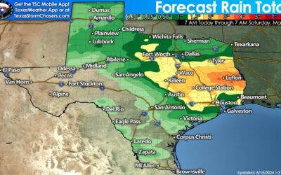
Chance of precipitation on Thursday/Thursday Evening
Showers and a few storms will be possible further north across Northeast and East Texas on Thursday as the low pushes east. Instability values will be much lower but we’ll have to watch for a few elevated storms capable of hail. Showers will be possible behind the surface low in North Texas into Northeast/East Texas during the afternoon and evening hours Thursday.

06Z NAM Surface Chart at 9 PM Friday
By tomorrow evening the surface low should be well east of Texas. The northwest flow on the backside of the low will quickly push a cold front through most of the state and into the Gulf of Mexico. Northwest winds and cooler temperatures will move into all of Texas by tomorrow night. For those in the warmer weather today and tomorrow – enjoy it because Friday and the weekend will be much cooler.

0 Comments