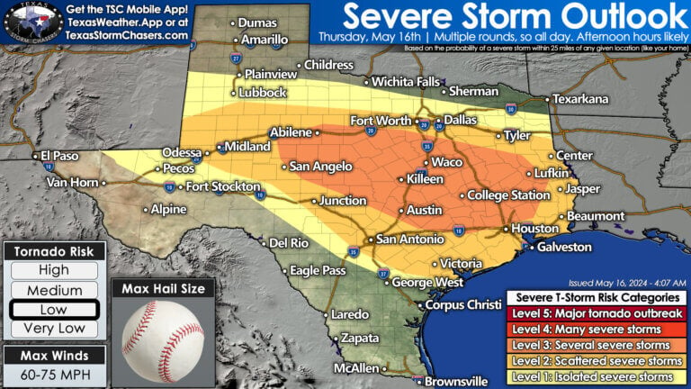
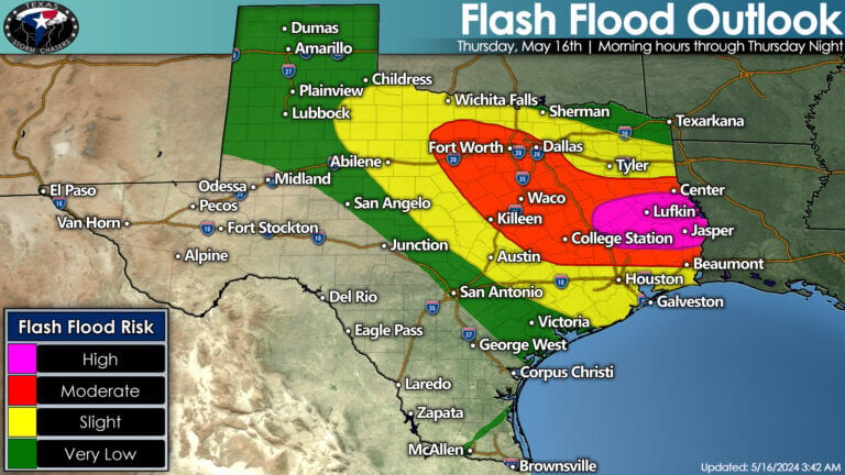
Prepare for significant flooding and severe storms that are set to pummel several regions of Texas from this morning through Friday morning. The threat is real, with a high risk of flash flooding, potentially life-threatening, along with very large hail, damaging winds, and a few tornadoes all looming large.
Thunderstorms have been making a ruckus across parts of Northwest Texas overnight. We anticipate an uptick in thunderstorm coverage across the Big Country and North Texas a few hours after sunrise. It’ll probably be a wet day for the state’s northern half. Flooding will become more problematic across the D/FW Metroplex around or by lunchtime. Some storms may be producing hail this morning.
As we progress into the late morning and afternoon, expect vigorous thunderstorm development from the Permian Basin, Big Country, Concho Valley, east into North-Central Texas. These thunderstorms are likely to produce flooding rainfall. Some storms may escalate to severe levels, with large to destructive hail and damaging winds. We anticipate storms to also develop, or move, into the Hill Country, Central Texas, Brazos Valley, and eventually Southeast Texas this afternoon and evening.
The most intense of these storms could produce giant hail larger than the size of a baseball, localized damaging wind gusts over 70 MPH, and a few tornadoes. Flooding rainfall is also a significant risk. There is a real concern that multiple heavy thunderstorms will move over the same location – producing localized rainfall amounts approaching 6-9 inches by Friday morning. This risk is highest in the Brazos Valley east into the Piney Woods of East Texas, along with Southeast Texas and the Golden Triangle.
Where this excessive rainfall occurs, significant to life-threatening flash flooding will occur due to saturated soils. These areas have experienced nearly 600% of their average rainfall over the last two weeks. All this new water will result in another flood wave in downstream lakes and rivers in Southeast and East Texas into next week.
Scattered storms will probably continue overnight across the state, but we should start calming down late tonight and into Friday morning. Spotty activity will continue on Friday morning. Hopefully, by late Friday afternoon,, we will only have isolated thunderstorm chances back on the dryline in western portions of Texas, where they need the rain. Friday night through Monday are looking mostly quiet in the storm department across Texas. Get ready for summer heat and humidity statewide this weekend and next week.
Helpful Links
Check out our current LIVE STREAM: https://texasweather.video/
Our FREE WEATHER APP: https://texasweather.app/
Our WEBSITE/RADAR: https://www.texasstormchasers.com/radar
Our SOCIAL PLATFORMS: https://linktr.ee/texasstormchasers


A busy day ahead for the eastern half of Texas. A lot of rain and flooding; with nasty storms likely increasing this afternoon with all-hazards of severe weather. We’ll do our best to keep Y’all updated! Best way to do that is with our free Texas Storm Chasers mobile app if you don’t already have it. (Search for Texas Storm Chasers where you download apps for your device.) If needed, live severe weather coverage will be on this channel as well.