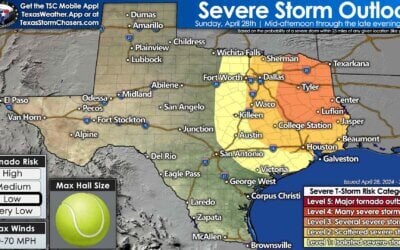
A portion of the severe weather outlook has been upgraded to level 3 (Enhanced). Houston, Liberty, Lumberton, Beaumont, Kirbyville, and Orange are all included cities included in the level 3 zone. A level 2 (elevated risk) includes all of Southeast Texas. A level 1 (marginal risk) zone includes Northeast Texas and East Texas. The enhanced risk zone was added where confidence is highest that a few severe storms will occur this evening and tonight. Large hail remains the primary concern with this evening’s storms in all three zones. A brief tornado can’t be ruled out in the enhanced risk zone.
Thunderstorm development is anticipated between 6 PM and 8 PM near the Houston metro. Those storms will move east/northeast and exit Texas by 2 AM. Compared to earlier this morning it does look like things may be an hour or two slower. That’s why we’ve moved the timing back by two hours. Thunderstorm coverage should increase after 8 PM across East and Southeast Texas. The atmosphere will be most unstable east of Interstate 45 and within 75-100 miles of the coast. That is the zone where the severe weather risk will be highest. Large hail up to the size of golfballs will be possible with the most intense storms. Storms may slightly elevated which would keep the threat of damaging winds and tornadoes very low. Confidence in severe weather occuring is below-average due to ongoing cloud cover, the initiation time of storms, and if they’ll be surface-based or elevated. It seems likely we’ll have some hailers this evening. One or two storms may become surface-based near the coast or in Far Southeast Texas this evening. For that reason the threat for a tornado is non-zero in that area. Widespread flash flooding is not expected.


0 Comments