
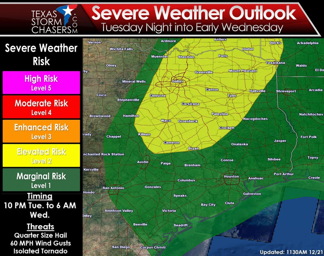
Good Evening! For a detailed update on the the potential for fog tonight and temperature trends over the next few days head over to Jenny’s blog update posted earlier this evening. I’ll be covering the potential for a few severe thunderstorms across the eastern sections of our state Tuesday Night. As has been common this fall (and now winter) the severe weather threat will be overnight and involve a high shear/low instablity setup. I’ll go into more detail about that below. For now lets go over the latest severe weather outlook from the Storm Prediction Center. This was issued this morning and we’ll have a new one just after midnight. At this time they have an elevated risk of severe weather across North-Central Texas and Northeast Texas. A marginal risk of severe weather includes Central Texas, Southeast Texas, and East Texas.

One model’s projection of available instablity by midnight – this is only one of many ingredients that goes into the forecast. Don’t focus on the bullseye of highest instablity or think that is where the severe weather threat will exist.
A weak cold front has allowed drier air to push the richer moist air into Southeast/South-Central Texas this evening. Over the next twenty-four hours we’re going to see all that moisture return north as an upper level disturbance approaches the region. At the same time the atmosphere will become more unstable tomorrow night. Some may be wondering why the atmosphere will become more unstable at night. It has to do with increasing low-level moisture and cooling mid-level temperatures. By late Tuesday evening we should have a marginally unstable airmass in place along/east of Interstate 35 from Central Texas north to the Red River. There remains some uncertainty on how far north surface-based instablity can get. Surface-based instablity allows thunderstorms to pose a tornado threat assuming other ingredients support such a threat. In cool season severe weather the event is generally driven by kinematics (strong wind shear) allowing for lower instablity amounts. Winds around 18,500 feet ASL will be out of the southwest around 60 MPH. Winds at around 5,000 feet ASL will be out of the south/southwest at about 55 MPH. Winds just above the surface should be out of the south at 30 to 40 MPH with surface winds out of the south around 20-25 MPH. That turning in the low-levels certainly supports the possibility of organized thunderstorms Tuesday Night across Northeast Texas, East Texas, and to a lesser extent Southeast Texas.

Storm Relative Helicity (SRH) in lowest 3 kilometers of the atmosphere tomorrow night. This is one way of measuring the amount of ‘spin’ available for potential thunderstorms. Again this is only one of several different ingredients we look at with potential severe storms.
The warm-air advection process tomorrow will bring more humid/unstable air northward but will also bring a cap. The cap will make things a little more difficult tomorrow evening in terms of thunderstorm coverage. I do expect a couple discrete severe thunderstorms tomorrow night in Northeast Texas. I’m less confident about the number of storms we’ll see develop further south in Southeast Texas. Ingredients will certainly be favorable for severe weather in both geographical locations – but uncertainty over the number of storms is why a marginal risk is in effect for Southeast Texas versus an elevated risk.
The latest weather model data coming in this evening so far suggests we should have thunderstorms start to fire up after 10 PM – possibly closer to midnight – across eastern sections of North Texas and Northeast Texas. These storms would move northeast around 40-45 MPH. The strongest storms could be severe with quarter size hail, localized damaging wind gusts over 60 MPH, and possibly a tornado threat. If surface-based instablity is slower to develop or further south than the storms would be elevated and be a hail/wind threat. We’ll have to watch trends closely since the event will be driven by strong wind shear versus instablity values. Storms may begin to develop further south into East Texas after midnight into the morning hours Wednesday. A more significant/high-end severe weather outbreak looks possible to our east in Mississippi and Alabama on Wednesday and Wednesday Night. As always small changes in the forecast can play a more significant role in the overall event. We’ll continue looking over data tonight and have a complete update in your Texas Weather Roundup in the morning.


0 Comments