
Summary:
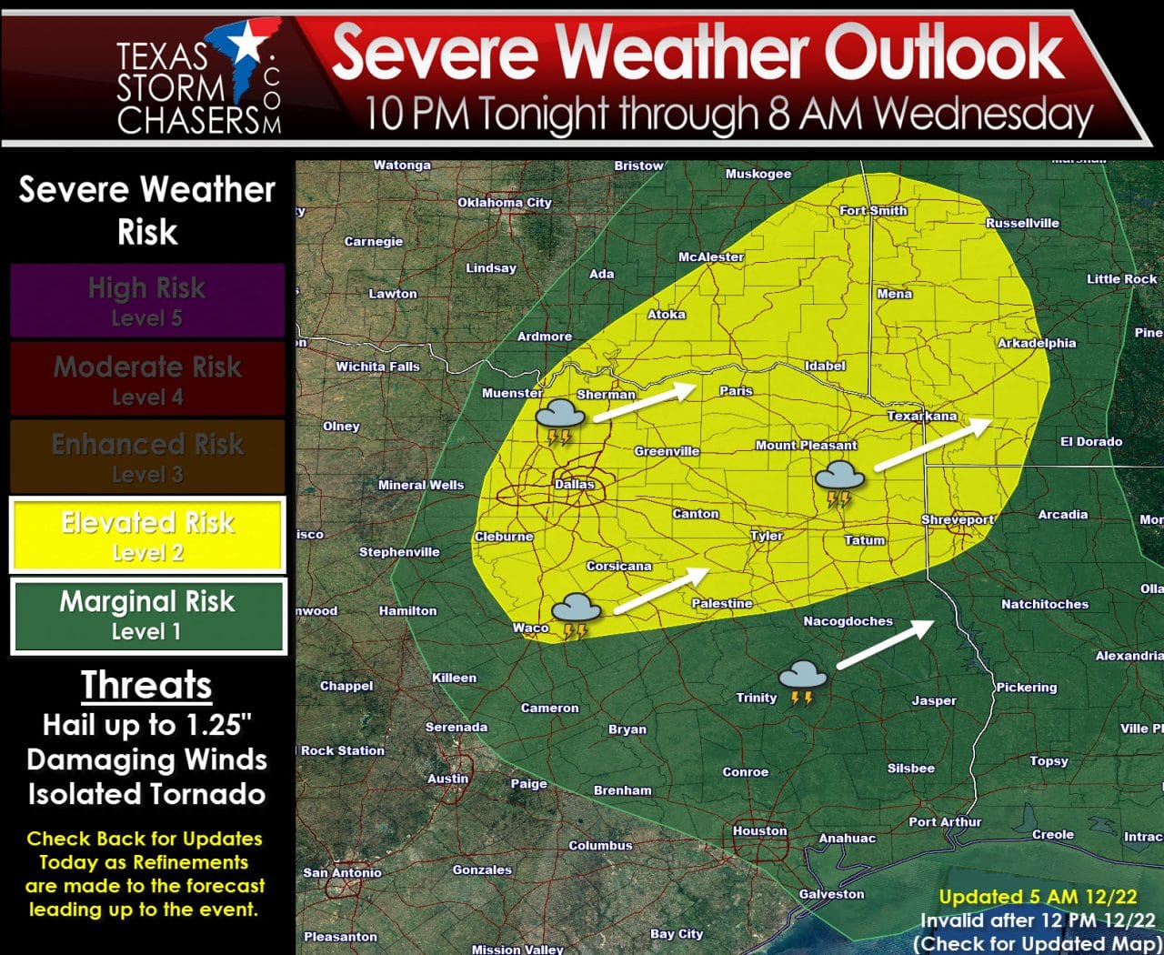
Thunderstorms are not expected today or early this evening. The main show will likely be after 10 PM tonight. Initial thunderstorm develop is likely to occur near Interstate 35 in North Texas. These initial storms have the potential to be supercellular in nature with a large hail threat. IFthe atmosphere becomes unstable enough at the surface it is possible damaging winds and isolated tornadoes could occur. Storms will move northeast at 40-45 MPH across Northeast Texas. One or two severe storms will be possible across East Texas and Far Southeast Texas during the morning hours Wednesday.
Detailed Discussion
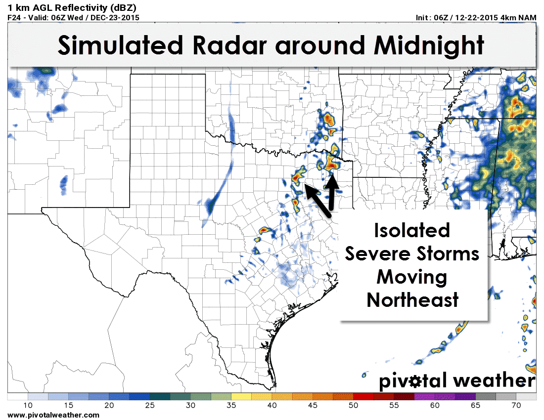
Another night-time severe weather setup is upon us as El Nino continues to influence our weather. Storms won’t be a problem during the daytime. In fact most of South and Southeast Texas are shrouded in a layer of dense fog at the time of this writing. That moisture will stream northward this afternoon. Dewpoint values will rise into the 50s and 60s along and east of Interstate 35 from North-Central Texas into East Texas by early this evening. At the same time an upper level disturbance will cause temperatures in the mid and upper levels of the atmosphere to cool. With increasing surface moisture and cooling mid-level temperatures the atmosphere will rapidly destabilize this evening in the severe weather risk zone. A cap will be in place which will keep a lid on thunderstorm development until after 10 PM this evening. As the upper level disturbance moves overhead its likely a couple of thunderstorms will develop near or just east of the D/FW Metroplex around 11 PM to 12 AM. These storms will move northeast around 40-45 MPH. The environment around the storms will contain moderately-strong wind shear values and be at least marginally unstable. Cool-season severe weather events are driven by kinematics (wind shear) versus thermodynamics (instablity). The atmosphere itself won’t be strongly unstable but it looks like it’ll have enough instablity to support a severe weather threat. Those storms that develop tonight could become supercells with organized updrafts. When folks hear ‘supercell’ they immediately think tornado – but that is usually not the case. A majority of supercells are non-tornadic but are severe with large hail and localized damaging wind gusts. Some supercells are elevated above a layer of stable air near the surface which greatly diminishes the threat of a tornado.
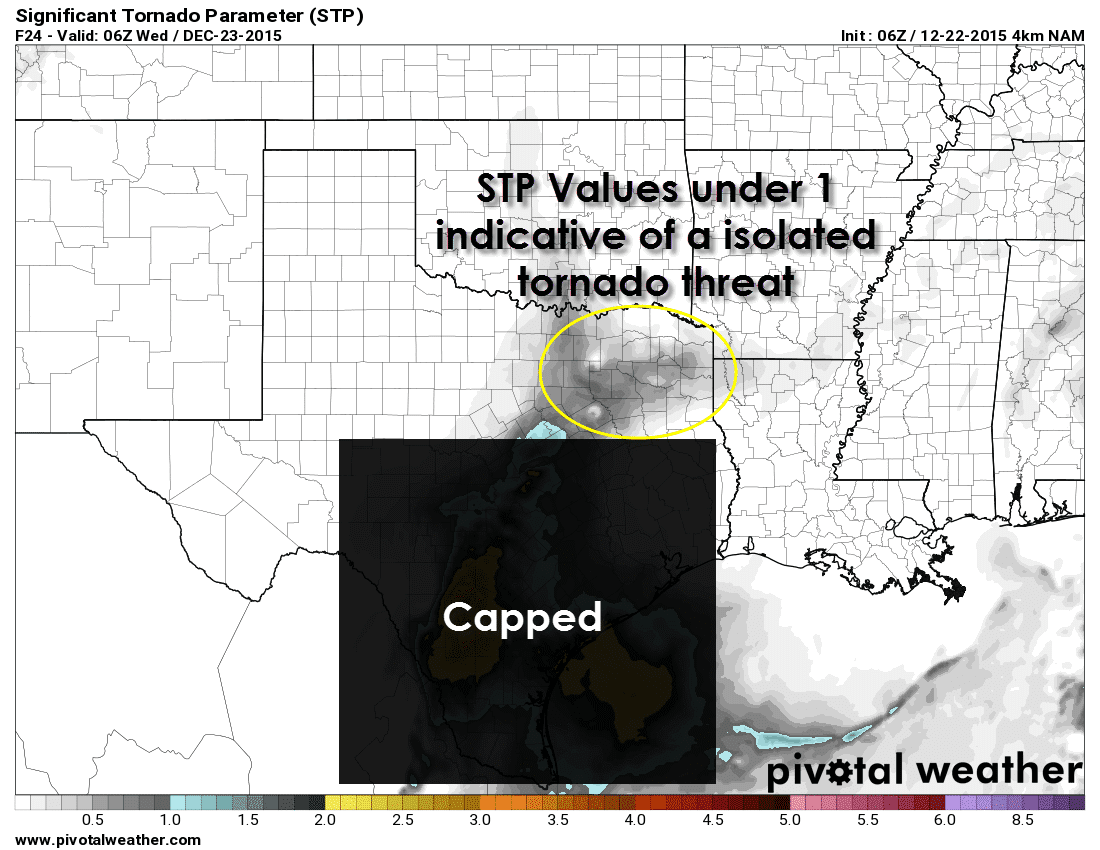
The Significant Tornado Parameter (STP) is one way to measure the potential for tornadic weather. Mind you there are many different algorithms/ingredients that come into play but the STP is an easy way to look over the potential. We generally want to see STP values over 1 or 2 to become concerned about tornadoes. The high-resolution North American Model does have STP values of 0.5 to just under 1 tonight across North Texas and Northeast Texas. Those STP values are not high by any means but they indicate an isolated tornado could occur tonight. By far I expect pocket-change size hail to be the primary hazard with any severe storm tonight. Strong low-level wind shear will be in place so we can’t rule out an isolated tornado or two. If we did have a tornado threat develop it would be caused by mesoscale factors like locally stronger wind shear or a boundary interaction. Those mesoscale factors can’t be accurately forecast more than a few hours in advance in many cases. Considering we’re still 18 hours out from any potential storm issues we have time to refine the forecast.
0 Comments