
Near Record Warmth Today

Temperatures will approach or set new records this afternoon. High temperatures across all of Texas will range from 75 degrees all the way up to 90 degrees. The warmest spots look to be the Hill Country, South Texas, and the Rio Grande Valley. With grasses dormant across Texas and the hot temperatures today there will be elevated fire danger.
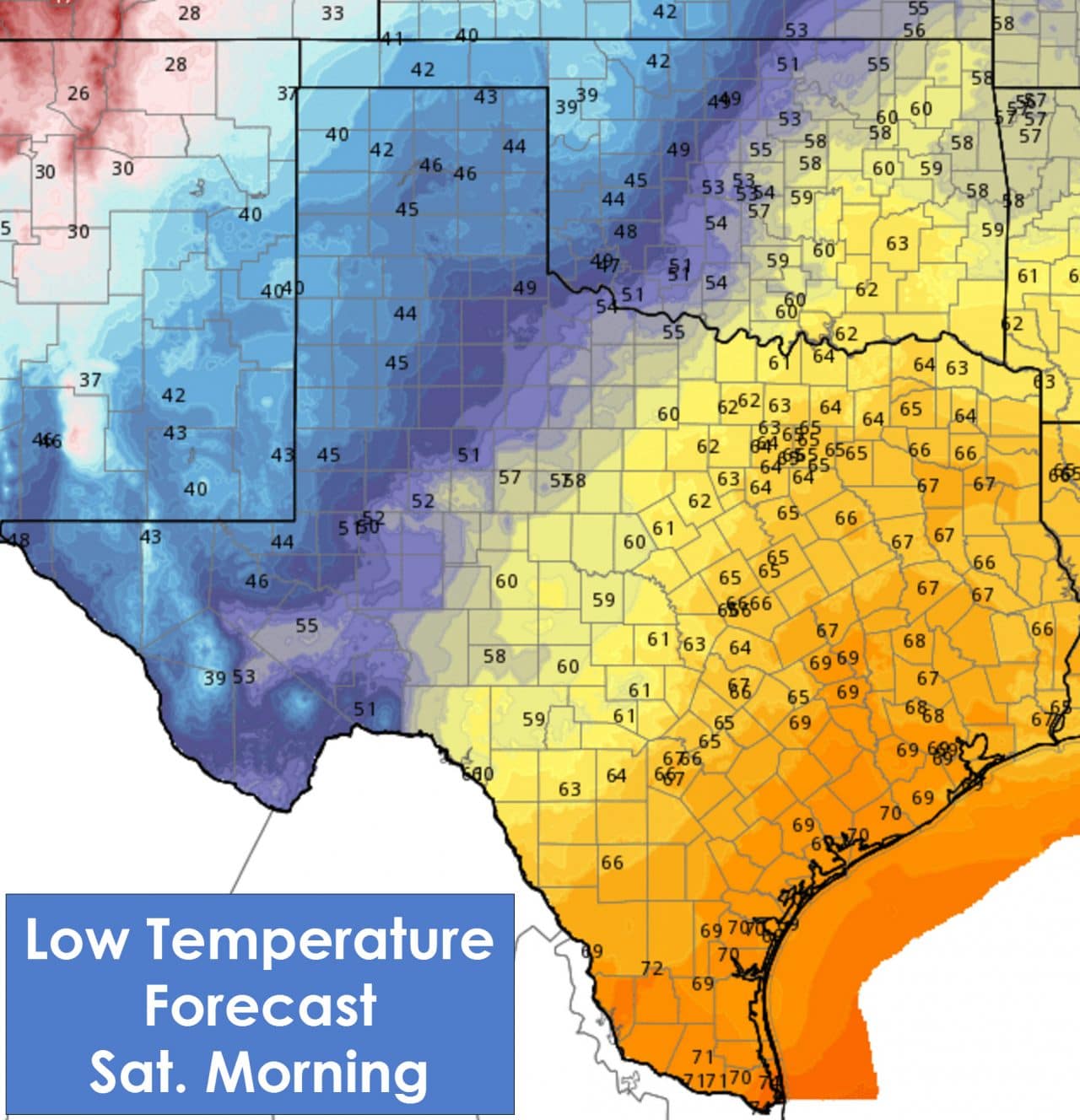
Low temperatures tonight will be very warm south/east of a warm front with 60s to low 70s. Overcast skies are expected with pockets of mist and fog. The Texas Panhandle, West Texas, the Permian Basin, and Northwest Texas will be in the 40s to low 50s.
Precipitation Forecast
I expect we’ll see another night of low-level overcast and perhaps even fog across the eastern half of Texas. Areas of mist or even light rain may form after midnight across South Texas, Central Texas, North Texas, into Northeast Texas and East Texas. By sunrise and afterwards we could have widespread mist to very light rain across the eastern two-thirds of Texas. Either way its going to be cloudy, humid, and quite warm. South winds will be noticeable with it feeling like an April day compared to December. Rainfall intensity looks to increase across East Texas by late morning. Thunderstorms will also be possible across Northeast Texas, East Texas, and the Brazos Valley. Locally heavy rain will be possible along with a few stronger storms. Heavy rain and locally strong storms will continue into the evening hours across Northeast Texas and East Texas. Some locations may receive 3 to 4 inches of rain with localized flash flooding possible. By late Saturday afternoon into the evening hours focus will also shift west. A second line of thunderstorms looks to fire up in Northwest Texas, the Big Country, and Concho Valley. This line of storms will quickly move east across North Texas, Central Texas, and South Texas during the nighttime hours Saturday into the morning hours on Sunday. This line will continue to move east quickly after sunrise on Sunday. By Sunday afternoon the showers and storms should be east of Texas.
Flash Flooding Potential
There will be two rounds of thunderstorms on Saturday into Sunday. The first round will be capable of producing several hours of heavy rain acrsos Northeast Texas, East Texas, and parts of North Texas generally east of Interstate 35. Based on the amount of moisture expected to be in place there will be the potential for localized flash flooding. Rainfall totals of 3 to 4 inches will be common with some locations receiving slightly more. Banding/training could play a role with a tight gradient between lighter rain totals and areas of heavier multi-inch rain. I don’t anticipate a significant/widespread flooding event – but there will be some issues with flash flooding on Saturday in the areas mentioned previously.
Severe Weather Potential
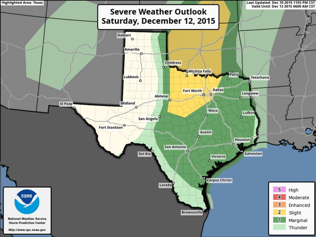
The severe weather potential with the ‘first’ line of storms across Northeast Texas and East Texas Saturday afternoon is marginal. A couple storms may become strong enough to produce localized damaging wind gusts. Strong wind shear will be in place but surface based instablity looks to be minimal. If for some reason we had the atmosphere destabilize we could have a low-end tornado risk in Northeast and East Texas tomorrow afternoon and evening.
The primary focus for severe weather will be a conditional threat during the late afternoon and early evening hours across western North Texas, Northwest Texas, and adjacent parts of Southwest Oklahoma. If the atmosphere is able to destabilize (with a few breaks in the clouds or less rain than expected) than there could be a few low-topped supercells. These storms would be fast moving to the north/northeast with a threat of damaging wind gusts and brief tornadoes. Those hazards are conditional on the storms even developing – which is far from guaranteed. What looks more likely is a line of storms firing up in those areas early Saturday evening. That line would book it east overnight Saturday into Sunday morning impacting all of North Texas, Central Texas, and East Texas. The line itself could contain localized damaging wind gusts over 60 MPH and a low-end tornado threat.
Winter Weather Potential

There is the potential for light snow across the Texas Panhandle Saturday Night and early Sunday. There remains some uncertainty regarding total amounts but at this point it looks like a minor event. The northern Texas Panhandle could receive 1 to 2 inches of snow. Snow accumulations of a dusting up to 1 inch are possible across the remainder of the panhandle. Some bridges may get a bit icy.


0 Comments