
Temperature Forecast through Thanksgiving into the Weekend
Temperatures will be warm through Thursday across most of Texas. A strong cold front begins to push into the Panhandle on Thursday and will quickly move south Thursday Night into Friday. High temperatures on Friday may occur early in the day with much colder temperatures for the afternoon hours. Temperatures behind the cold front will fall into the 30s and 40s with gusty north winds. Wind chill values will be in the 10s/20s on Friday and Saturday. Chilly weather will remain in place through the weekend.
Chance of Precipitation through Thanksgiving into the Weekend
Rain chances will ramp up on Thursday with the potential for heavy rain Thursday Night. There may be a bit of a break/lull on Friday before a second round of heavier precipitation moves in Friday Night into Saturday. There remains plenty of uncertainty and you can expect changes for the forecast as new data helps refine things.
Severe Weather Outlook
Severe weather is not expected with this system. A few stronger storms may occur across the South Plains and Permian Basin on Thursday with small hail. Otherwise the atmosphere will be too stable to support organized thunderstorms or a severe thunderstorm threat.
Flood Outlook

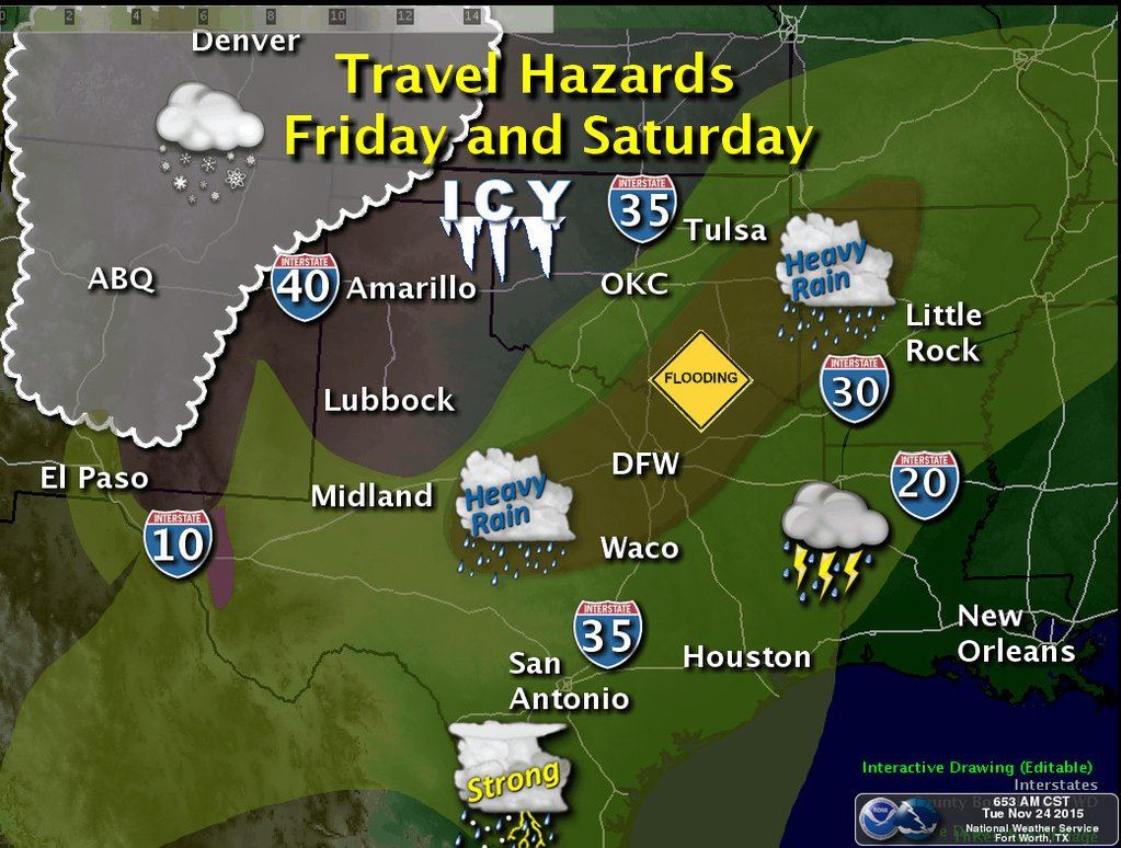
A fairly significant flooding threat may develop on Thursday Night, Friday, and Saturday across parts of Texas. The heaviest rains are currently forecast to fall across the Concho Valley, Big Country, Northwest Texas, Central Texas, North Texas, and Northeast Texas. Widespread rain accumulations of 2 to 5 inches can be expected. Isolated rain totals up to 8 inches are possible. Once we get above about 3 inches we’ll have to keep an eye on increased flash flooding potential. Most of the regions I mentioned here have experienced at least one good freeze this fall. Vegetation is becoming dormant and thus the ground won’t be able to absorb as much water. Of all the potential issues with this upcoming system I do believe flooding could be the most significant issue by the time all is said and done. Stay tuned as timing and the heaviest rain axis information will likely change as we get additional data over the next few days. Flash flood watches will likely be issued for some areas for this event.
Winter Weather Potential

As temperatures fall to or below freezing we’re expecting a switchover from rain to freezing rain across parts of the Texas Panhandle. Timing aspects and the accumulation potential remains very uncertain. At this time the most likely time for freezing rain seems to be from late Thursday Night through Saturday. Hazardous travel conditions are likely across the Texas Panhandle on Friday as freezing rain creates ice accumulations. Depending on how much freezing rain/ice accumulates there could be isolated power outages and tree damage. We’ll have to keep a close eye on things as a lot of moisture will be in place and this could become a fairly substantial winter weather event. The arctic airmass is shallow in the low-levels of the atmosphere. Temperatures will be above freezing a few thousand feet above the surface. That’s why we’re not expecting much snow Freezing rain and some sleet should be the primary winter weather mode across most of the Panhandle. The atmosphere may become cold enough to support a sleet/snow mix across the northwestern Texas Panhandle on Friday and Saturday. Winter weather is not expected further east in Texas thanks to warm air advection keeping temperatures safely above freezing. This has the potential to become a winter storm in the Texas Panhandle with significant impacts. If you’re planning to travel in the Panhandle on Friday and Saturday be ready to change those plans. A winter storm watch may be required by tomorrow.


0 Comments