
The Storm Prediction Center has issued a TORNADO WATCH for counties along the Sabine river in far eastern Texas through 5pm central time. So far this morning, extensive cloud cover has kept atmospheric instability at minimal levels. However, as we get closer to the early afternoon hours, we could see some clearing which may allow surface heating and instability values to increase with time which could increase the threat of a tornado spin-up. Residents in far east Texas should keep an eye on the sky this afternoon and have a way to receive weather warnings if any are issued for your specific location.
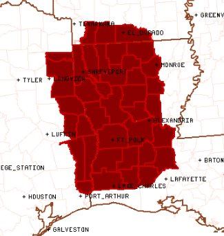
Counties included in the WATCH: Orange, Jasper, Newton, Sabine, Hemphill, Shelby, Panola and Harrison
Cities included in the WATCH: Newton, Jasper, Hemphill, San Augustine, Center, Carthage, Marshall, Jefferson and Linden.
TORNADO WATCH NUMBER 501
   NWS STORM PREDICTION CENTER NORMAN OK
   1105 AM CST MON NOV 28 2016

   THE NWS STORM PREDICTION CENTER HAS ISSUED A

   * TORNADO WATCH FOR PORTIONS OF
     EXTREME SOUTHERN ARKANSAS
     MUCH OF WESTERN AND NORTHERN LOUISIANA
     EXTREME EAST TEXAS

   * EFFECTIVE THIS MONDAY MORNING AND AFTERNOON FROM 1105 AM UNTIL
     500 PM CST.

   * PRIMARY THREATS INCLUDE...
     A FEW TORNADOES POSSIBLE
     SCATTERED DAMAGING WIND GUSTS TO 70 MPH LIKELY
     ISOLATED LARGE HAIL EVENTS TO 1.5 INCHES IN DIAMETER POSSIBLE

   SUMMARY...THUNDERSTORMS WILL SLOWLY INCREASE IN COVERAGE AND
   INTENSITY THROUGH THE AFTERNOON WHILE SPREADING EASTWARD FROM TEXAS
   INTO LOUISIANA.  THE STORM ENVIRONMENT WILL BECOME MORE FAVORABLE
   FOR SUPERCELLS WITH THE POTENTIAL TO PRODUCE A FEW TORNADOES THIS
   AFTERNOON...ESPECIALLY WITH THE MORE ISOLATED NOW FORMING NEAR THE
   SABINE RIVER.  ALSO...A LINE OF STORMS ACROSS NORTHEAST TEXAS AND
   SOUTHERN ARKANSAS WILL LIKELY BECOME BETTER ORGANIZED THROUGH THE
   AFTERNOON AND POSE A RISK FOR DAMAGING WINDS.


0 Comments