
Today, we are facing a critical and dangerous situation as dangerous wildfire conditions are set to engulf the Texas Panhandle, West Texas, Permian Basin, Big Bend, Trans-Pecos, Guadalupe, and Davis Mountains, extending into the Borderland in Far West Texas. To simplify, the entire western third of Texas is at risk. With humidity values ranging from five to fifteen percent and wind gusts expected to reach up to forty-five miles per hour, the potential for rapid to explosive growth of fires is high. We urge you to postpone any outdoor activities that could potentially ignite a spark.
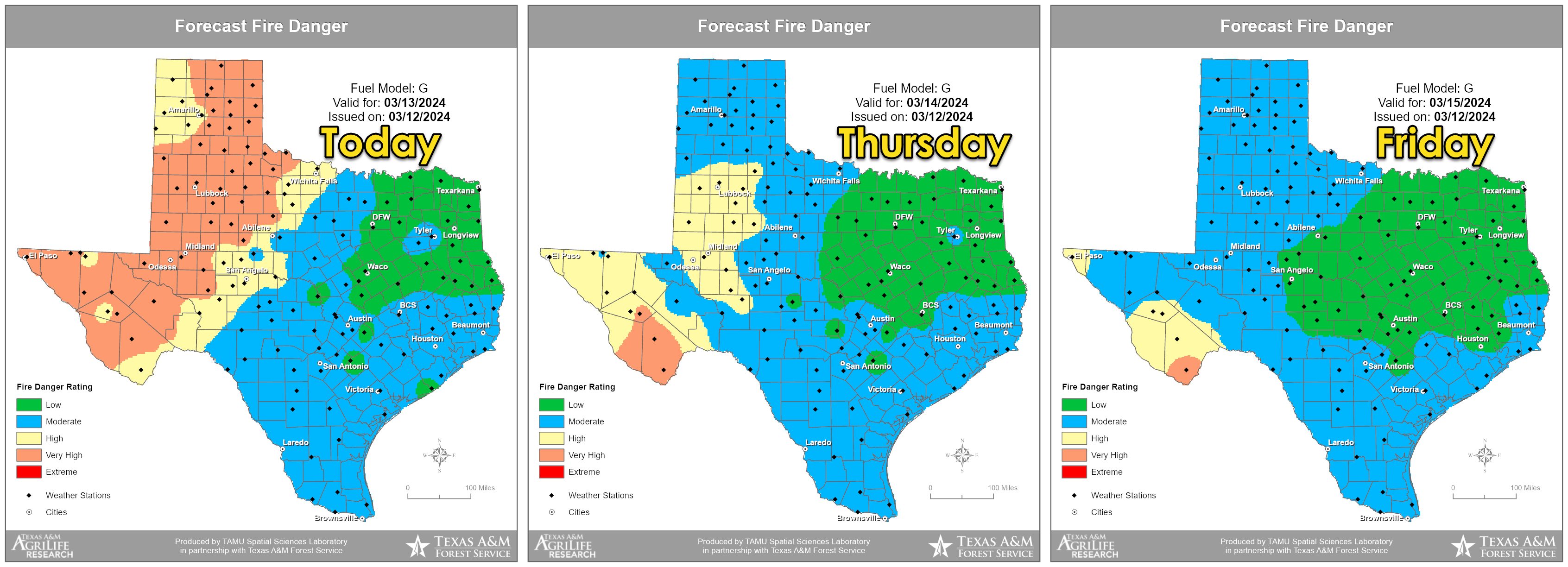
Be prepared to evacuate if necessary. Fire warnings will be issued by local emergency management and national weather service offices. These warnings should be treated with the same urgency as tornado warnings. The risk is not limited to the Panhandle, with the entire western third of Texas under threat. While wind speeds may not be as extreme as the February event, with gusts of forty to forty-five miles per hour expected, we cannot rule out a rogue wind gust over fifty miles per hour. The situation will ease slightly on Thursday and Friday, but the danger will remain very high in Big Bend, Southwest Texas, and the Borderland in Far West Texas.
Severe Thunderstorms on Thursday
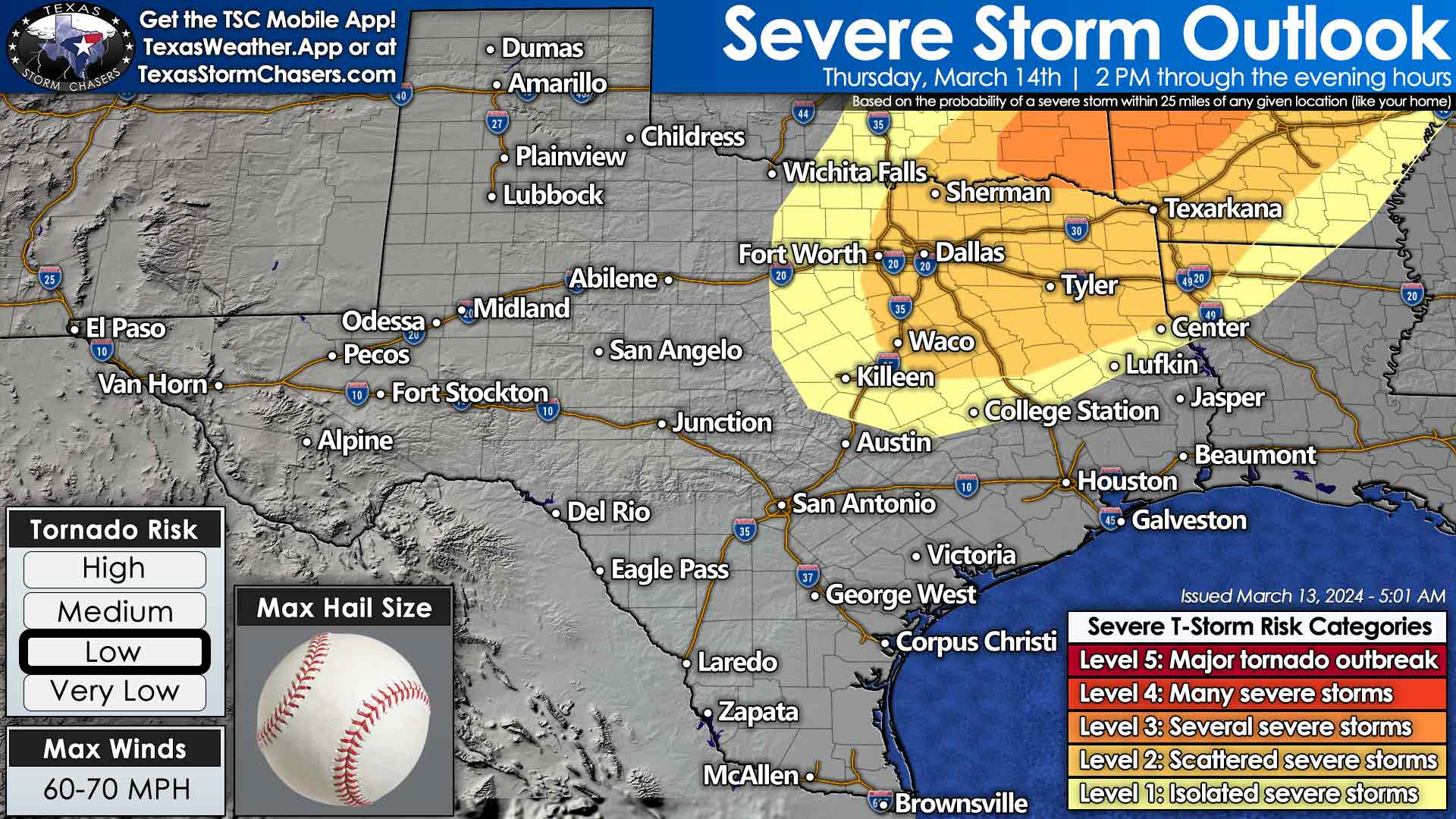
Tomorrow, our focus will shift from fire weather to convective weather. The Storm Prediction Center has identified the northeastern quarter of Texas as a potential hotspot for severe thunderstorms. The most intense storms, expected from mid-afternoon through the evening, could bring about significant damage. We’ll closely monitor North Texas, eastern Texoma, Northeast Texas, and the Ark-La-Tex for the highest chance of scattered severe thunderstorms. These storms could produce hail as large as baseballs, wind gusts exceeding sixty-five miles per hour, and even a few tornadoes. Heavy rainfall is also a concern, with the risk of localized flooding increasing across the eastern third of Texas as we approach the weekend. Tomorrow could be a challenging day for Northeast Texas, and we’ll have storm chasers ready to provide live video coverage of the event.
Thunderstorms and Cooler Weather Friday into the Weekend
A cool front will slowly move south into Texas tomorrow night and continue to progress south as we move into the weekend. A series of upper-level storm systems will move across Texas through the weekend. Thanks to a REX block, we’ll see our upper-level pattern continue to throw pieces of upper-level lift across Texas. Several days of scattered showers and thunderstorms will be the result. It won’t rain in any given location all the time, and some unlucky folks may not see much at all.
However, some places may have several inches of rainfall by Monday morning, with rain chances continuing early next week. The best chance for at least two inches of rain by Sunday night will be in the eastern third of Texas. Sunday night into Monday should feature good rain chances for the southwestern third of Texas. Some severe thunderstorm potential may develop on Friday across the Hill Country, Central Texas, the Brazos Valley, East Texas, and Southeast Texas.
The highest chance for thunderstorms with heavy rainfall and potential hail on Friday and Saturday will depend on where the cool front ends up. There remains disagreement in weather model data, so some north or south shifts are probable in future forecasts. Regardless, unsettled weather is expected across much of Texas through the weekend and early next week. We need the rain before the summer of hell number three arrives. The free Texas Storm Chasers mobile app lets you get your local weather forecast for the next several days. Search for Texas Storm Chasers where you download apps for your mobile device.
Temperatures will cool as the front moves south into Texas this weekend, along with widespread cloud cover. We are not anticipating a major arctic outbreak.

Not lookin like much fun, for Texas!
Frank Haugh Congratulations…
𝐃𝐞𝐚𝐫 𝐃𝐨𝐧’𝐭 𝐒𝐤𝐢𝐩👍👍
🎁 Get Walmart $100 Gift Card Instantly.
😲We announce 10,000 winners from Walmart $100 Gift Card every year
and we have you among them.𝐕𝐢𝐬𝐢𝐭 𝐓𝐡𝐞 𝐋𝐢𝐧𝐤 𝐁𝐞𝐥𝐨𝐰 𝐅𝐨𝐫 𝐌𝐨𝐫𝐞 𝐃𝐞𝐭𝐚𝐢𝐥𝐬⤵⤵ 👇
https://kgadeal.com/walmart
JessenTanda Sperling
Austin Kinsler
Karinda Kinsler Congratulations…
𝐃𝐞𝐚𝐫 𝐃𝐨𝐧’𝐭 𝐒𝐤𝐢𝐩👍👍
🎁 Get Walmart $100 Gift Card Instantly.
😲We announce 10,000 winners from Walmart $100 Gift Card every year
and we have you among them.𝐕𝐢𝐬𝐢𝐭 𝐓𝐡𝐞 𝐋𝐢𝐧𝐤 𝐁𝐞𝐥𝐨𝐰 𝐅𝐨𝐫 𝐌𝐨𝐫𝐞 𝐃𝐞𝐭𝐚𝐢𝐥𝐬⤵⤵ 👇
https://kgadeal.com/walmart
Congratulations…
𝐃𝐞𝐚𝐫 𝐃𝐨𝐧’𝐭 𝐒𝐤𝐢𝐩👍👍
🎁 Get Walmart $100 Gift Card Instantly.
😲We announce 10,000 winners from Walmart $100 Gift Card every year
and we have you among them.𝐕𝐢𝐬𝐢𝐭 𝐓𝐡𝐞 𝐋𝐢𝐧𝐤 𝐁𝐞𝐥𝐨𝐰 𝐅𝐨𝐫 𝐌𝐨𝐫𝐞 𝐃𝐞𝐭𝐚𝐢𝐥𝐬⤵⤵ 👇
https://kgadeal.com/walmart
West Texas needs rain bad. Bring it
Yay 72 hrs makes the difference of maybe rain to nope chance for fire in west central….
I’ll believe it when I see it about the rain
All I want is rain! Pray fires and severe storms stay at bay.
I want to give a huge shout-out to our top Stars senders. Thank you for all the support!
Stephanie Smith Robinson, Doris Myrick, Preston H. Pollister
Gods mad at Idiot Abbott
Fire tornados
Saw one today outside odem
I’m so confused 🙄😃🌬️☀️⛅️🥶🌥️