
Today’s forecast is a messy one and dependent on a few factors. A nearly-stationary cold front extending from the Concho Valley eastward into southern North Texas will be one factor. Storm mode and the timing for severe weather chances this afternoon and evening are the second and third factors. A weak cap means it won’t take much lift to generate showers and storms, which can also be a complicating factor in timing.
Scattered thunderstorms dropped several inches of rain last evening and overnight across portions of the Concho Valley and North Texas. As many can attest, those storms did not lack in the heavy rainfall department. Very high moisture values by April standards meant the most intense storms were able to produce two to three inches of rain per hour. Those high rainfall rates, even if they only lasted for 30-60 minutes, resulted in localized flash flooding. That isn’t surprising when you consider it’s not too dissimilar to a cow taking a leak on a flat rock. All that liquid has to go somewhere! We’ll continue to be concerned about the localized flash flooding threat today, but the risk of severe storms will be on an uptick by this afternoon.
Click image for full resolution version
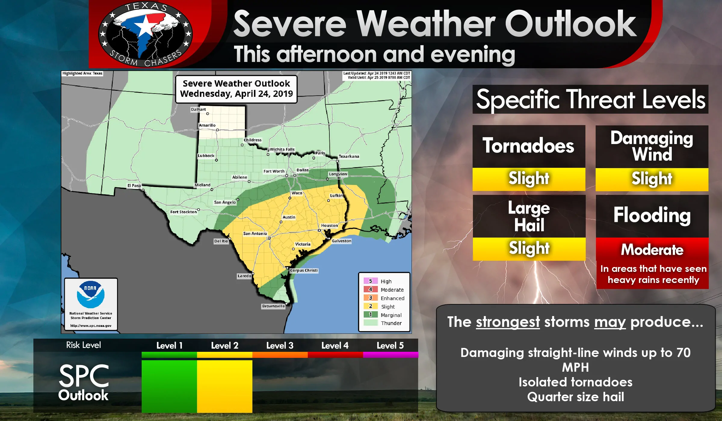
We have a level two risk of severe weather – the standard risk level – across the Edwards Plateau, Hill Country, Central Texas, South Texas, Coastal Plains, Brazos Valley, East Texas, and in Southeast Texas. A level one marginal risk extends a bit north and south of the level 2 zone. Being in or near either risk zone means you could have some strong to severe storms in your general area today. It is not a guarantee you’ll experience severe storms.
Here are regional graphics of the severe weather outlook for today. You can click any graphic on this post for a full-resolution version.
Among a larger area of showers and storms, we could see a few stronger storms underway by late morning in the Hill Country. The stronger storms could be producing hail and localized damaging wind gusts, although most activity will be capable of producing heavy rainfall. As storms move east toward Interstate 35 in Central/South-Central Texas by early afternoon there are indications we could see a squall line, or small bow echo, take shape. A bow echo is when a line of storms ‘bows’ out. Bow echos typically have enhanced damaging straight-line wind potential along with the possibility of brief tornadoes (usually within stronger areas of straight-line wind, so both are equally dangerous).
That squall line will move east across the Brazos Valley into East Texas and Southeast Texas from the mid-afternoon hours through the early evening. The strongest storms may be capable of producing damaging straight-line winds over 70 MPH, brief tornadoes, quarter size hail, and very heavy rainfall. Due to saturated soil conditions, it won’t take all that much wind to uproot trees. Last week’s storms were a testament to the ease of uprooting trees given the wet soil. Be very mindful of that threat as storms (even those not considered severe) move in this evening across East Texas.
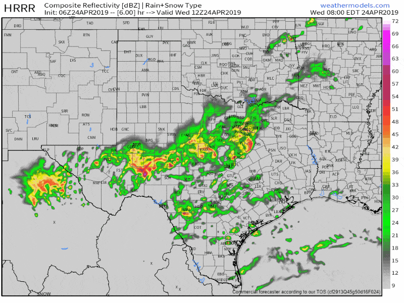
Simulated weather model radar from 7 AM today until midnight. This is only a simulation, and given the complicating factors in today’s forecast (as described at the top of this post), caution should be used.
If we have any ‘discrete’ storms fire up this afternoon in Central Texas, South-Central Texas, or the Brazos Valley we would have to watch them for a low-end risk of producing a tornado. That tornado risk isn’t high, but it isn’t zero either. Luckily, we should be going to a linear storm more fairly quickly. That line of storms is what will move east across the Brazos Valley, Coastal Plains, East Texas, and Southeast Texas this afternoon and evening.
Not all storms in the squall line will be severe. Most storms will be capable of producing heavy rainfall. The good news is the line itself should be moving east at a decent clip. That should help keep the threat of flash flooding more localized. Nevertheless, we could still see some flooding in parts of North/Central Texas today as storms move over areas that have already received their fair share of the rain. Some isolated flash flooding may also occur in the Brazos Valley as storms drop a quick 1 to 2 inches of rain. We will have to deal with a larger-scope/longer-duration river flood event later this week and into the first week of May as flood waters from the north move downstream through their respective river basins.


0 Comments