
Potential Tropical Cyclone #3 has resumed a north/northwest movement this evening. A. PTC #3 is expected to organize and become a classified tropical storm tomorrow. These ‘Potential Tropical Cyclone’ advisories are new to the 2017 hurricane season. They allow the National Hurricane Center to issue tropical storm watches/warnings ahead of time; versus waiting until the system to form perhaps just a few hours off-shore. This system will likely become Tropical Storm Cindy on Tuesday as it already has tropical storm force winds. A primary reason we don’t have a named storm yet is due to the lack of a well-defined low-level circulation. Once that develops we’ll have Tropical Storm Cindy. While we will likely have a tropical storm the probability of this system becoming a hurricane is low, but not impossible. Regardless it appears that prolific rainfall will be the primary hazard along and well to the east of the system’s track. The potential for 5+ inches of rain and flooding could extend several hundred miles east of the actual track. There remains uncertainty over the eventual track of PDC #3 but models have become more focused on the idea of a far Southeast Texas/Lousiana landfall by Thursday. Remember, the worst impacts including tropical storm force winds, isolated tornadoes, and very heavy rainfall will be along and east of the center’s track. Those to the west of the track will have some rain chances, but impacts will be much lower. On the current projected track, there may be a risk for heavy rainfall and flooding in extreme Southeast and East Texas. Our concern for the heaviest rains would be east of the state line. However, any shift west in future track updates will result in those impacts shifting west into more of Texas.
The probability of this system becoming a hurricane is low, but not impossible. Regardless it appears that prolific rainfall will be the primary hazard along and well to the east of the system’s track. The potential for 5+ inches of rain and flooding could extend several hundred miles east of the actual track. There remains uncertainty over the eventual track of PDC #3 but models have become more focused on the idea of a far Southeast Texas/Lousiana landfall by Thursday. Remember, the worst impacts including tropical storm force winds, isolated tornadoes, and very heavy rainfall will be along and east of the center’s track. Those to the west of the track will have some rain chances, but impacts will be much lower. On the current projected track, there may be a risk for heavy rainfall and flooding in extreme Southeast and East Texas. Our concern for the heaviest rains would be east of the state line. However, any shift west in future track updates will result in those impacts shifting west into more of Texas. The National Hurricane Center did shift the projected track and uncertainty cone a tad west in the 10 PM CT advisory update. Their forecast remains a bit east of the model projected guidance, but without a defined low-level circulation, this remains a below-average forecast. We’ll have to see where this defined circulation forms tomorrow. Landfall should be late Wednesday, but that timing could still change by ~12 hours. The most probable location seems to be in far Southeast Texas into Lousiana. Remember, don’t focus on the center line. Impacts will be felt several hundred miles east of the center’s track. The system will turn more north on Thursday and northeast into Arkansas by late Thursday. It’ll be gone by the weekend.
10PM CT National Hurricane Center Advisory

Potential Tropical Cyclone Three Advisory Number 2
NWS National Hurricane Center Miami FL AL032017
1000 PM CDT Mon Jun 19 2017
…DISTURBANCE MOVING SLOWLY NORTH-NORTHWESTWARD OVER THE CENTRAL
GULF OF MEXICO…
SUMMARY OF 1000 PM CDT…0300 UTC…INFORMATION
———————————————–
LOCATION…24.4N 89.5W
ABOUT 325 MI…525 KM S OF THE MOUTH OF THE MISSISSIPPI RIVER
ABOUT 380 MI…610 KM SSE OF MORGAN CITY LOUISIANA
MAXIMUM SUSTAINED WINDS…40 MPH…65 KM/H
PRESENT MOVEMENT…NNW OR 330 DEGREES AT 8 MPH…13 KM/H
MINIMUM CENTRAL PRESSURE…1000 MB…29.53 INCHES
WATCHES AND WARNINGS
——————–
CHANGES WITH THIS ADVISORY:
None.
SUMMARY OF WATCHES AND WARNINGS IN EFFECT:
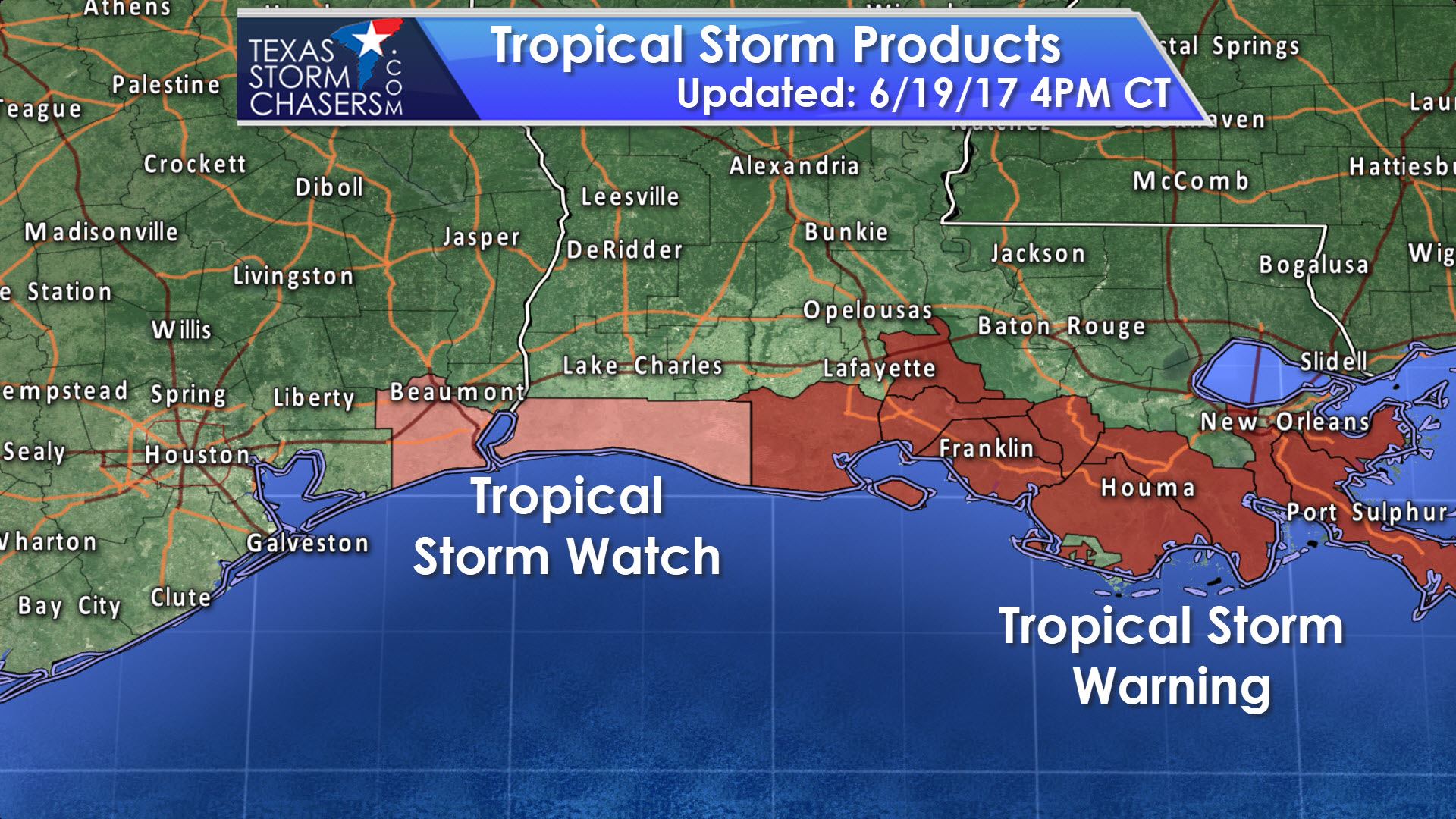
A Tropical Storm Warning is in effect for…
* Intracoastal City to the Mouth of the Pearl River
A Tropical Storm Watch is in effect for…
* West of Intracoastal City to High Island
A Tropical Storm Warning means that tropical storm conditions are
expected somewhere within the warning area, in this case within the
next 24 to 36 hours.
A Tropical Storm Watch means that tropical storm conditions are
possible within the watch area, generally within 48 hours.
Interests elsewhere along the U.S. Gulf Coast from the central Texas
coast to the western Florida Panhandle should monitor the progress
of this system.
For storm information specific to your area, including possible
inland watches and warnings, please monitor products issued by your
local National Weather Service forecast office.
DISCUSSION AND 48-HOUR OUTLOOK
——————————
At 1000 PM CDT (0300 UTC), the disturbance was centered near
latitude 24.4 North, longitude 89.5 West. The system is moving
toward the north-northwest near 8 mph (13 km/h). A turn toward the
northwest should occur by Tuesday morning, and that motion is
expected to continue into Wednesday. On the forecast track, the
disturbance is expected to be near the Louisiana coast on
Wednesday.
Maximum sustained winds are near 40 mph (65 km/h) with higher gusts.
Some slight strengthening is possible before the system reaches the
coast.
Upper-level winds are expected to be marginally conducive for some
additional development of this system during the next day or two,
and a tropical or subtropical cyclone is likely to form during that
time.
* Formation chance through 48 hours…high…80 percent
* Formation chance through 5 days…high…80 percent
Tropical-storm-force winds extend outward up to 205 miles (335 km)
to the north and east of the center.
The estimated minimum central pressure is 1000 mb (29.53 inches).
HAZARDS AFFECTING LAND
———————-
WIND: Tropical storm conditions are expected to first reach the
coast within the warning area by Tuesday afternoon. Tropical storm
conditions are possible in the watch area on Wednesday.
RAINFALL: The disturbance is expected to produce total rain
accumulations of 4 to 8 inches with isolated maximum amounts of
10 inches over southeastern Louisiana, southern Mississippi,
southern Alabama, and the Florida Panhandle through Wednesday
evening.


0 Comments