
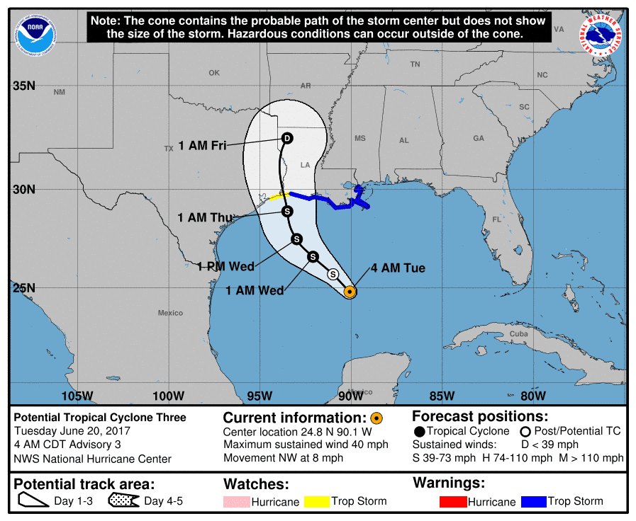
Data rolling in overnight suggests that PTC#3 is gradually becoming better defined and more organized, but has still not reached tropical storm status. It will likely be later today when we see PTC#3 upgraded to Tropical Storm Cindy. Latest model data also suggests a slight westward shift of the forecast track due to the strengthening of a high pressure ridge sitting over the western Atlantic; however, the National Hurricane Center is still maintaining eventual landfall along the coastline between far southeast Texas and far southwestern Louisiana on Thursday. One thing to keep in mind though is, no matter where the storm makes landfall, rain and near tropical storm force winds extend out quite a distance from the center, so residents all along the southeast coast of Texas to the central coast of Louisiana will need to be prepared for wind and very heavy rainfall as this system draws closer to the coast. It is still NOT expected to reach hurricane force before making landfall. Highest forecast sustained winds are expected to be in the 45mph range (Tropical Storm Force Winds) but even those winds can caused damage to trees, power lines and loose objects that end up blown about. Coastal flooding, especially to the north and east of the center of the storm, will be the greatest threat with portions of Louisiana forecast to receive upwards of 8 inches as this system moves onshore. A Tropical Storm WATCH remains in effect for west of Cameron, Louisiana, to High Island, Texas. A Tropical Storm WARNING remains in effect from Cameron Louisiana to the mouth of the Pearl River near Slidell, Louisiana.
POTENTIAL TROPICAL CYCLONE THREE FORECAST/ADVISORY NUMBER   3
NWS NATIONAL HURRICANE CENTER MIAMI FL       AL032017
0900 UTC TUE JUN 20 2017

CHANGES IN WATCHES AND WARNINGS WITH THIS ADVISORY...

A TROPICAL STORM WARNING IS NOW IN EFFECT FROM CAMERON LOUISIANA
TO INTRACOASTAL CITY.

SUMMARY OF WATCHES AND WARNINGS IN EFFECT...

A TROPICAL STORM WARNING IS IN EFFECT FOR...
* CAMERON TO THE MOUTH OF THE PEARL RIVER

A TROPICAL STORM WATCH IS IN EFFECT FOR...
* WEST OF CAMERON TO HIGH ISLAND

A TROPICAL STORM WARNING MEANS THAT TROPICAL STORM CONDITIONS ARE
EXPECTED SOMEWHERE WITHIN THE WARNING AREA...IN THIS CASE WITHIN
THE NEXT 24 TO 36 HOURS.

A TROPICAL STORM WATCH MEANS THAT TROPICAL STORM CONDITIONS ARE
POSSIBLE WITHIN THE WATCH AREA...GENERALLY WITHIN 48 HOURS.

INTERESTS ELSEWHERE ALONG THE U.S. GULF COAST FROM THE CENTRAL TEXAS
COAST TO THE WESTERN FLORIDA PANHANDLE SHOULD MONITOR THE PROGRESS
OF THIS SYSTEM.


0 Comments