
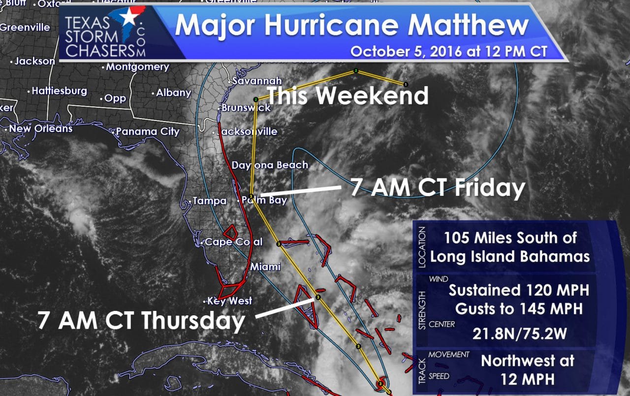
Major Hurricane Matthew moved over portions of Haiti and Cuba during the last 24 hours. The minimum central pressure has risen from 934 millibars early yesterday to 962 millibars just before lunch today. Maximum sustained winds have come down a bit but remain quite significant at 120 MPH. Matthew moved back over the warm waters south of the Bahamas a couple hours ago. Since that time new thunderstorms have begun to develop and the system is starting to reorganize. Water temperatures and the oceanic heat content remain very high – jet fuel to hurricanes. Wind shear remains no the low side. Based on the improving sattilite appearance and very strong winds aloft detected by the hurricane hunters a strengthening trend is anticipated to begin shortly. Maximum sustained winds are forecast to increase back to 130 MPH – a category 4 hurricane. Wind gusts will exceed 150-160 MPH. Those winds will be the strongest in a small section of the storm with 50 to 100 MPH much more widespread. This will be a major hurricane as it approaches the eastern coast of Florida tomorrow. Any small intensity changes won’t make much difference – the key is to being prepared for a major hurricane.
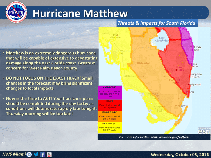
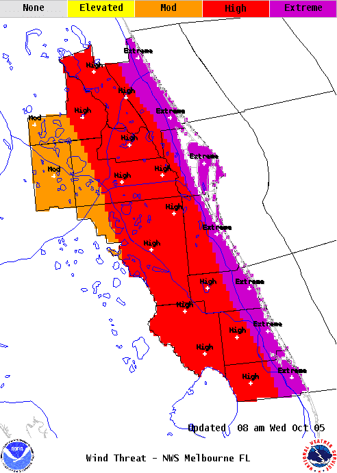
The storm is moving northwest at 12 MPH this afternoon. That motion and trend will continue tonight. A direct impact on Nassau is probable late tonight into the morning hours Thursday. The outer bands of Matthew will approach and begin impacting Florida during the afternoon hours Thursday. The timeframe where the system will be at its closest – or even make a direct landfall – will be during the late evening hours Thursday. Whether the eye is sitting 10 miles off shore or makes it on shore will make little difference to the immediate coastline. Devastating wind gusts over 125 MPH – potentially higher – are expected on parts of the eastern Florida coast. Storm surge values of 3 to 6 feet with another 5 to 10 feet of battering waves are forecast. Tropical storm force winds will extend inland to nearly Orlando. If the storm takes a small wobble west and makes landfall we’re going to see more wind inland. Any shift east – off shore – will keep the highest winds in closer proximity to the coast. All this could change and thus we’ll have to closely watch trends today.
The key message is that regardless of the system making landfall or skirting just off-shore the impacts will be similar. This is a dangerous and major hurricane. THose in the impacted area should follow local emergency management advice. If you’re ordered to evacuate – do so. We’ll be keeping tabs on this system from a meteorological perspective. Hopefully the trend will be for a more eastward and off-shore movement. However, that has not been the trend this morning.
BULLETIN
HURRICANE MATTHEW ADVISORY NUMBER 30
NWS NATIONAL HURRICANE CENTER MIAMI FL AL142016
1100 AM EDT WED OCT 05 2016
…POWERFUL HURRICANE MATTHEW HEADING FOR THE BAHAMAS AFTER HITTING
CUBA HARD…
…NOAA AND AIR FORCE HURRICANE HUNTER PLANES SIMULTANEOUSLY
PENETRATE MATTHEW’S EYE…
SUMMARY OF 1100 AM EDT…1500 UTC…INFORMATION
———————————————–
LOCATION…21.8N 75.2W
ABOUT 55 MI…90 KM NNE OF CABO LUCRECIA CUBA
ABOUT 105 MI…165 KM S OF LONG ISLAND BAHAMAS
MAXIMUM SUSTAINED WINDS…120 MPH…195 KM/H
PRESENT MOVEMENT…NW OR 325 DEGREES AT 12 MPH…19 KM/H
MINIMUM CENTRAL PRESSURE…962 MB…28.41 INCHES
WATCHES AND WARNINGS
——————–
CHANGES WITH THIS ADVISORY:
The Hurricane Warning has been extended northward from Sebastian
Inlet to the Flagler/Volusia county line.
The Hurricane Warning for Haiti has been changed to a Tropical
Storm Warning.
The government of the Dominican Republic has discontinued the
Tropical Storm Warning and Tropical Storm Watch for the Dominican
Republic.
SUMMARY OF WATCHES AND WARNINGS IN EFFECT:
A Hurricane Warning is in effect for…
* Cuban provinces of Guantanamo, Santiago de Cuba, Holguin, Granma,
and Las Tunas
* Southeastern Bahamas, including the Inaguas, Mayaguana, Acklins,
Crooked Island, Long Cay, and Ragged Island
* Central Bahamas, including Long Island, Exuma, Rum Cay,
San Salvador, and Cat Island
* Northwestern Bahamas, including the Abacos, Andros Island,
Berry Islands, Bimini, Eleuthera, Grand Bahama Island, and
New Providence
* North of Golden Beach to the Flagler/Volusia county line
* Lake Okeechobee
A Hurricane Watch is in effect for…
* Cuban province of Camaguey
* North of the Flagler/Volusia county line to Fernandina Beach
A Tropical Storm Warning is in effect for…
* Haiti
* Turks and Caicos Islands
* Chokoloskee to Golden Beach
* Florida Keys from Seven Mile Bridge eastward
* Florida Bay
Interests elsewhere in the Florida Peninsula and the Florida Keys
should monitor the progress of Matthew.
For storm information specific to your area in the United
States, including possible inland watches and warnings, please
monitor products issued by your local National Weather Service
forecast office. For storm information specific to your area outside
the United States, please monitor products issued by your national
meteorological service.
DISCUSSION AND 48-HOUR OUTLOOK
——————————
At 1100 AM EDT (1500 UTC), the eye of Hurricane Matthew was located
near latitude 21.8 North, longitude 75.2 West. Matthew is moving
toward the northwest near 12 mph (19 km/h), and this motion is
expected to continue during the next 24 to 48 hours. On this track,
Matthew will be moving across the Bahamas through Thursday, and is
expected to be very near the east coast of Florida by Thursday
evening.
Maximum sustained winds are near 120 mph (195 km/h) with higher
gusts. Matthew is a category 3 hurricane on the Saffir-Simpson
Hurricane Wind Scale. Some strengthening is forecast during the
next couple of days, and Matthew is expected to remain at category
3 or stronger while it moves through the Bahamas and approaches the
east coast of Florida.
Hurricane-force winds extend outward up to 45 miles (75 km) from the
center and tropical-storm-force winds extend outward up to 175 miles
(280 km). An unconfirmed wind gust of 155 mph (250 km/h) was
reported in Baracoa, Cuba, last night as the eye of Matthew passed
nearby.
The minimum central pressure reported by both Hurricane Hunter
planes was 962 mb (28.41 inches).
HAZARDS AFFECTING LAND
———————-
WIND: Hurricane conditions will gradually diminish over portions of
eastern Cuba today. These conditions will continue over the
southeastern Bahamas, and will spread over the central Bahamas later
today and the northwestern Bahamas tonight.
Hurricane conditions are expected to first reach the hurricane
warning area in Florida by late Thursday and will spread northward
Thursday night and Friday. Tropical storm conditions are first
expected in Florida by early Thursday.
RAINFALL: Matthew is expected to produce total rainfall amounts in
the following areas:
Southern Haiti and southwestern Dominican Republic…15 to 25
inches, isolated 40 inches
Eastern Cuba and northwestern Haiti…8 to 12 inches, isolated
20 inches
Eastern Jamaica…additional 1 to 2 inches, isolated storm totals
12 inches
The Bahamas…8 to 12 inches, isolated 15 inches
Turks and Caicos Islands…2 to 5 inches, isolated 8 inches
Northeastern Haiti and the Northern Dominican Republic…1 to 3
inches, isolated 5 inches
Coastal east-central Florida….4 to 7 inches, isolated 10 inches
Florida Keys….1 to 3 inches, isolated 5 inches
Life-threatening flash floods and mudslides are likely in southern
and northwestern Haiti, the southwestern Dominican Republic, and
eastern Cuba.
STORM SURGE: The combination of a dangerous storm surge and large
and destructive waves could raise water levels by as much as the
following amounts above normal tide levels…
Northern Coast of Cuba east of Camaguey…4 to 6 feet
The Bahamas…10 to 15 feet
The water could reach the following heights above ground if the peak
surge occurs at the time of high tide…
North Palm Beach to the Flagler/Volusia county line…3 to 5 ft
Surge-related flooding depends on the relative timing of the surge
and the tidal cycle, and can vary greatly over short distances.
Large waves generated by Matthew will cause water rises to occur
well in advance of and well away from the track of the center.
The combination of a dangerous storm surge and the tide will cause
normally dry areas near the coast to be flooded by rising waters
moving inland from the shoreline. There is a danger of
life-threatening inundation during the next 36 hours along the
Florida east coast from North Palm Beach to the Flagler/Volusia
county line. There is the possibility of life-threatening inundation
during the next 48 hours from north of the Flagler/Volusia county
line to Fernandina Beach. For a depiction of areas at risk, please
see the Prototype National Weather Service Storm Surge Watch/Warning
Graphic. For information specific to your area, please see products
issued by your local National Weather Service forecast office.
The Prototype Storm Surge Watch/Warning Graphic is a depiction of
areas that would qualify for inclusion under a storm surge watch or
warning currently under development by the National Weather Service
and planned for operational use in 2017. The Prototype Graphic is
available at hurricanes.gov.
SURF: Swells generated by Matthew will continue to affect portions
of the coasts of Hispaniola, eastern Cuba, and the Bahamas during
the next few days, and will spread northward along the east coast of
Florida and the southeast U.S. coast tonight and Thursday. These
swells are likely to cause life-threatening surf and rip current
conditions. Please consult products from your local weather office.


0 Comments