
Good morning and happy Sunday! Waking up to abundant 20s and 30s scattered across north and central Texas this morning now that the latest cold front has settled in across the state. We’ll see another night of frigid temps, then a warming trend for Monday into Thursday before our next strong cold front arrives . Let’s look at what today has in store, then we’ll take a preliminary look at what to expect later this week.
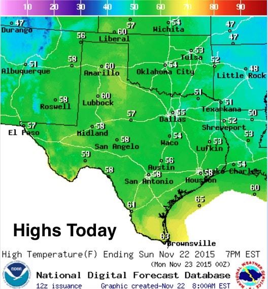

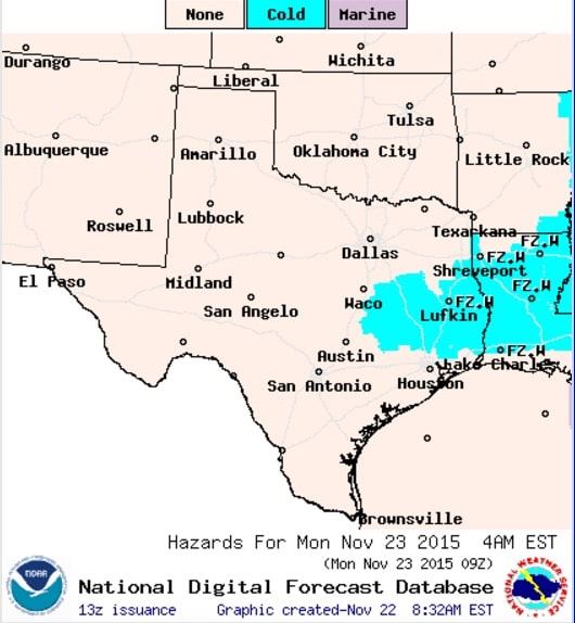
Highs today will be chilly and seasonable with highs mainly in the 50s across the entire state. We’ll see a few pockets of low 60s across south Texas, and a few across the panhandle region as winds begin to veer from the west/southwest again. Lows tonight will drop down into the 20s and 30s across a great portion of the state. The metro areas will stay mainly at or above freezing, but we’ll see outlying areas as far south as Lufkin drop down into the upper 20s. Freeze warnings will remain in place through tomorrow morning mainly for the northern portions of southeast Texas.
Forecast Synopsis for This Coming Week: Temps will quickly rebound Monday through Wednesday with above seasonal normals expected as we kick off the Thanksgiving Holiday week. Along with the warmer temps, rain chances will return starting Tuesday, and we could see a slight chance of a few Thunderstorms by Thanksgiving day for a few folks across the rolling plains of west central Texas. In addition to that, a strong cold front is expected to arrive Thursday and into Friday with precipitation chances expected to continue along and behind the front. Unlike our most recent front, we will see enough moisture return this week to produce rain and a some thunderstorms as the front dives south across the state on Thursday. At this time, atmospheric instability looks pretty meager, so we will likely not see any significant threat of severe weather, but we will keep an eye on it anyway. What will be critical to watch is the timing and amount of the precip expected after the front passes.

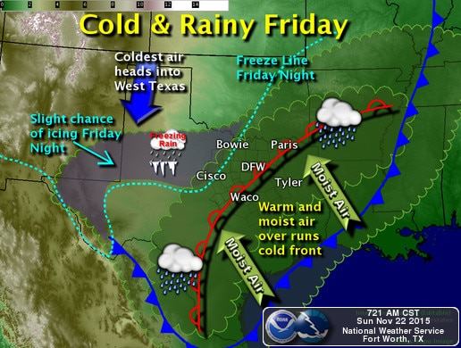
Current long-range models are starting to show consistency in bringing at least some threat of winter weather across the panhandle, west and west central Texas by Friday into Saturday…and possibly beyond. What they’re showing right now is an upper level low digging across the central rockies by late Wednesday with widespread lift over the western half of the state. The main energy from this low looks to lift off to the north/northeast by Friday, but what’s concerning is a piece of that energy left behind, possibly forming into a cutoff low over the desert southwest by Friday…and what appears to be a very late season hurricane impacting the Baja Mexico region by late Friday into early Saturday. As we’ve seen with past tropical systems in the Baja, we tend to get additional moisture streaming overhead which can enhance precipitation chances for Texas. The timing of the best precip chances in combination with cold continental air settling in over the state could bring travel disruptions to parts of the panhandle and west/west central Texas Friday into Saturday. We have to stress that it’s still too far out to make an accurate forecast for travel late this week, but we will continue to monitor and provide updates throughout the week.


0 Comments