
Temperatures are starting off quite chilly this morning across Texas. 6 AM temperature observations have freezing temperatures as far south as San Antonio into the Coastal Plains and just north of Houston. It’s on the chilly side in Deep South Texas with 30s – decently cold for that part of the state. We could see temperatures drop another degree but they’ll start climbing soon enough.

Light southerly winds and clear skies will allow temperatures to warm quite nicely by this afternoon. Northeast Texas will make it into the upper 50s as cooler air from Arkansas helps keep things a tad cooler. Southeast Texas, Central Texas, into the Hill Country and points north will climb into the mid 60s by this afternoon. Essentially all of Texas outside of Northeast Texas will climb into the 60s today with southerly winds of 5 to 15 MPH. Clouds may begin increasing by late afternoon in far Southwest Texas.

Tonight will be 10-15 degrees warmer than this morning across southern sections of Texas as clouds increase and we start to see a return flow of moisture. Temperatures will drop off into the 30s across the Panhandle, South Plains, and in Northeast and East Texas. North Texas, Central Texas, the Hill Country, Southeast Texas, and South-Central Texas will drop into the mid and upper 40s. Compare that to the upper 20s to mid 30s being observed this morning. The Rio Grande Valley and South Texas will drop into the 50s to low 60s tonight – also noticeably warmer thanks to increased cloud cover tonight.
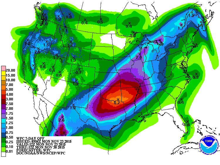
Upcoming rain accumulation forecast (which WILL change)
No hazardous weather is anticipated today or on Tuesday – but we will start to see changes by Wednesday as a storm system approaches from our west. We will have an additional blog later this morning to discuss the active weather expected beginning Thursday and continuing through Sunday. Light rain is expected to increase in coverage by Wednesday Night across parts of Texas. Thursday has the potential to be quite wet across the Texas Panhandle, West Texas, Permian Basin, Northwest Texas, Big Country, into North Texas. The overall severe weather threat will be very low. I can’t rule out an isolated strong storm in the Permian Basin – but cloud cover will greatly limit the atmosphere’s destabilization and any severe weather threat. By Thursday Night into Friday temperatures may cool enough to support a changeover to freezing rain across parts of the Texas Panhandle. Continued winter weather chances could occur on Friday, Saturday, and perhaps even Sunday across parts of the Texas Panhandle and South Plains. At this time temperatures are expected to remain above freezing across the rest of Texas. Record-high moisture levels for late November combined with the possibility of two storm systems Thursday through Sunday may create a flooding issue across the eastern half of Texas. Several inches of rain will be possible in this timeframe. Locations that have received a hard freeze over the past couple of days will have their vegetation going dormant. That means the ground will have slightly less of an ability to soak up water. I’ll have more specific details in the blog later this morning – but Thursday through Saturday has the potential to feature very active weather in parts of Texas. Stay tuned!

0 Comments