
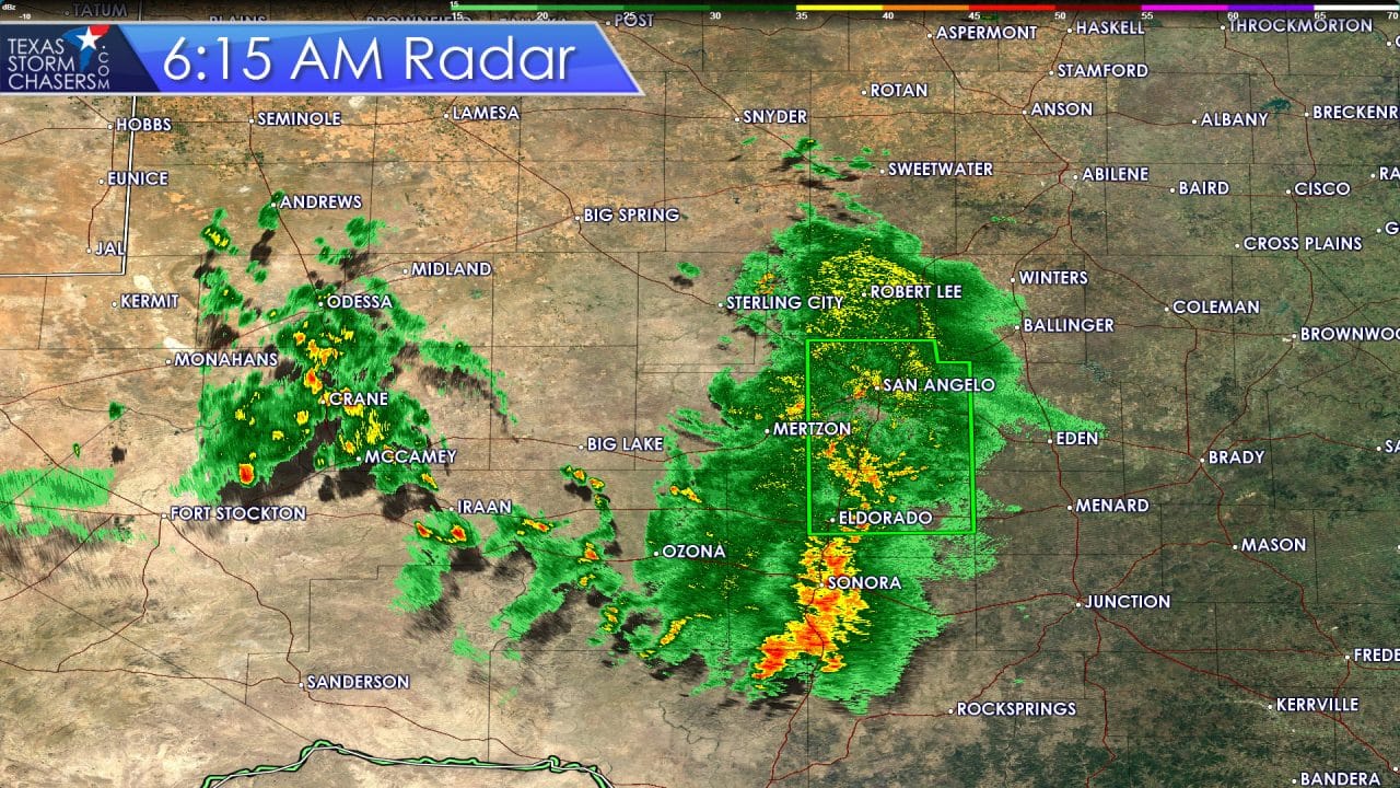
The Concho Valley and Southwest Texas have enjoyed a decent area of rain overnight. We do have some flash flooding issues around San Angelo where we’ve had a little too much rain fall in a short period. Otherwise we have partly cloudy to mostly cloudy skies this morning across Texas. Temperatures will climb fairly quickly as is usual for a late June day in Texas. By lunchtime we should see temperatures in the upper 80s to middle 90s across much of Texas. The exception will be in areas that are socked in with clouds or dealing with showers. By early to mid afternoon temperatures will be peaking in the middle to upper 90s across the eastern half of Texas. The western half of Texas will have temperatures a little cooler thanks to widespread clouds and showers. The heat ridge is a bit weaker over Texas this week. That means we’ll be dealing with a better chance for afternoon showers and storms.

Afternoon showers and thunderstorms are expected again today across a large portion of Texas. Like the past couple of days these storms will mainly be ‘popcorn’ storms with a lifespan of 45 to 60 minutes. Storms will go up in a hurry, make a ruckus for about 30 minutes, and weaken. During the weakening process the strongest storms could produce localized wind gusts over 50 MPH. Dissipating storms will also produce outflow boundaries which will act as a wave. Outflow boundaries will help spark off additional showers and storms. Those new storms will repeat the same process and that’s how we get a 20 to 30 percent coverage in storms during the afternoon hours. One benefit of the outflow boundaries are that they help cool temperatures into the low 80s. Most folks will remain dry today but those that end up under a popcorn storm could pick up a quick inch of rain. Storms produce dangerous cloud to ground lightning which is hazardous to those outdoors. If thunder roars you need to move indoors. Most folks treat lightning as something not to worry about – which is a bad move if you’re outdoors. Trees that get struck by lightning have a tendency to explode and shoot shrapnel at high rates of speed. Lightning that strikes a human body tends to be a critical to fatal injury. Its a good idea to remind folks about our more common hazards. Lightning may not be as horrifying as a tornado, flash flood, or hurricane but it is one of the most frequent and dangerous weather hazards we deal with on a daily basis.
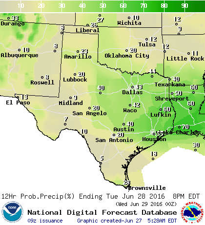
Chance of showers/storms on Tuesday
Shower and thunderstorm chances increase on Tuesday across the Big Country, Concho Valley, North Texas, Central Texas, East Texas, Northeast Texas, and Southeast Texas with scattered to numerous showers and storms expected. This is when the upper level high pressure will be weakest and thus the atmosphere will be mainly uncapped. As temperatures warm into the upper 80s and 90s we’ll have showers and storms developing by lunch. The ‘popcorn’ process described above will take place tomorrow but on a more numerous scale. Widespread severe weather is unlikely but some storms may become strong with small hail, gusty winds, and nearly continuous lightning. Very localized minor flash flooding may also occur if we see a heavy storm pop up over a urban area.
Off and on shower/storm chances will continue each afternoon this week. We may also have to deal with nighttime chances if we see a cluster of storms develop to our northwest. The chances of being impacted by thunderstorm complexes will depend on where they form and how much of a southward component of motion they take. For now it looks like most storm complexes will move through Kansas/Oklahoma versus Texas.


0 Comments