
Whoever complained about quiet weather in November and December can stop. We will be very busy over the next seven to ten days, with multiple opportunities for precipitation. Today alone, we’ve got a blizzard and the threat of severe storms in Texas. These are the days when weather folks don’t sleep much, and we won’t be doing any better as we trek toward the weekend. We’ve got a written article, but for the full forecast, hit up our Texas Weather Roundup video.
Blizzard in the Northern Texas Panhandle
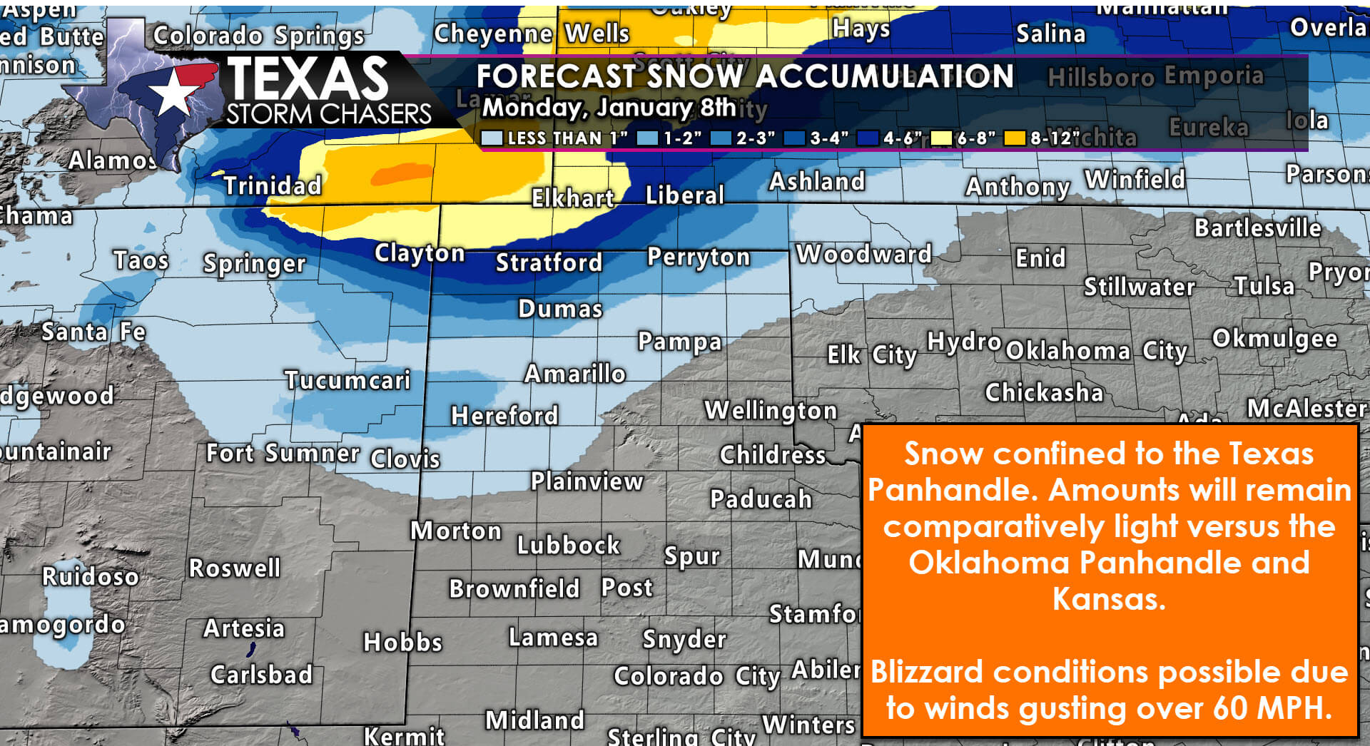
Forecast snow totals in the Texas & Oklahoma Panhandles for today.
Accumulating snow is likely across the northern Texas Panhandle this morning through this evening. Snowfall amounts will vary due to snow falling in heavier bands. Measuring the snow will be next to impossible due to winds gusting over 60 MPH. Blizzard conditions are likely where we see even modest amounts of snow accumulations. Across the northern Panhandle, into the Oklahoma Panhandle, two to eight inches of snow are possible. Snow drifts will be measured in feet, and damaging winds will result in power outages and life-threatening travel hazards. Snow will quit falling tonight, but gusty winds with blowing snow will continue into Tuesday morning.
Severe Thunderstorm Potential
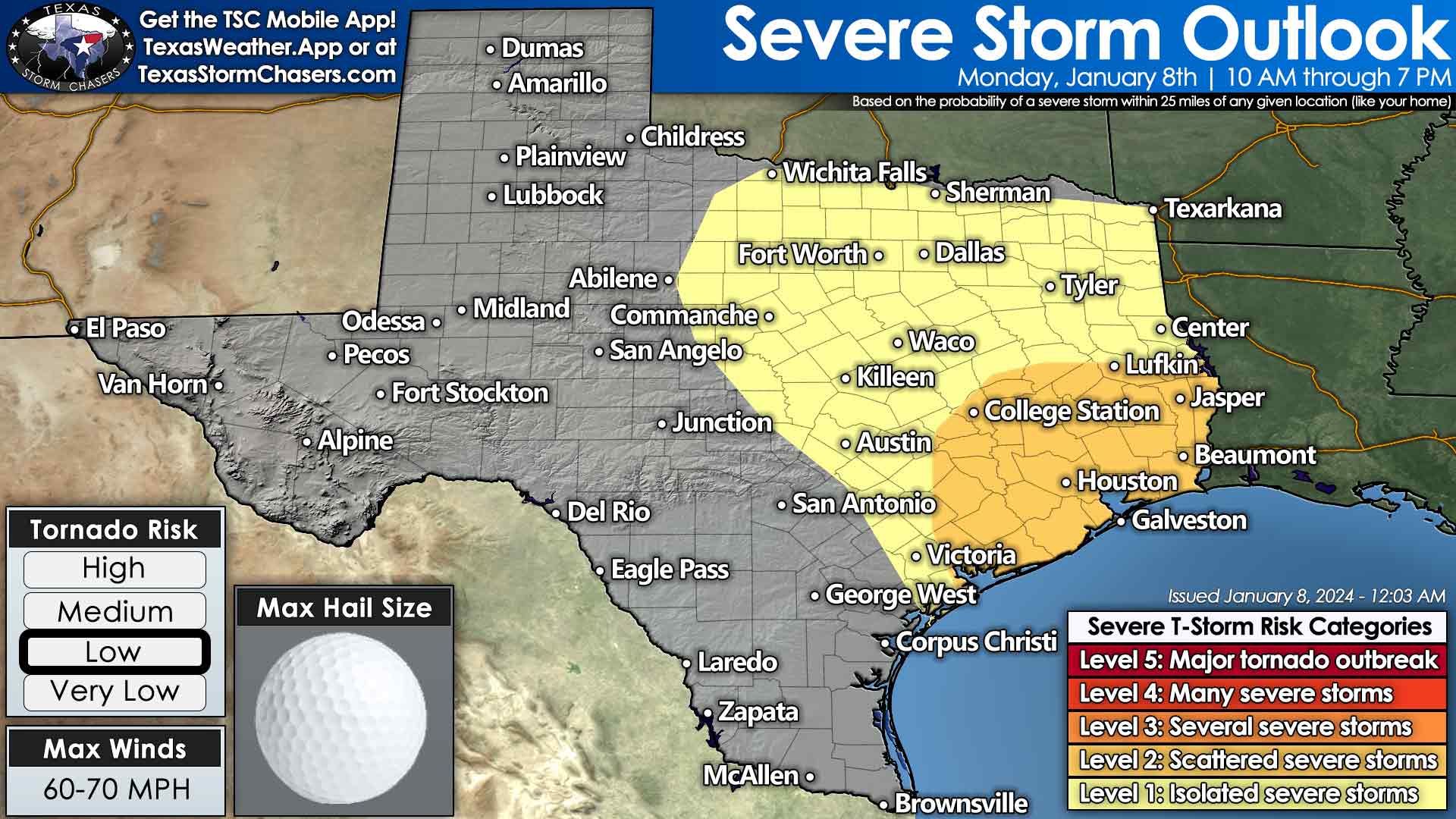
Severe thunderstorm outlook for Texas today. The highest threat for severe storms, including a few tornadoes, looks to be in Southeast Texas and the Golden Triangle (Far Southeast Texas). We’ll need to monitor trends carefully, as the risk may need to be increased.
A thin line of thunderstorms will quickly move east across the eastern half of Texas today. This line will be approaching Interstate 35 by mid-morning. Wind gusts over 50 MPH are possible, mainly due to intense winds just off the surface. Those heavier rains may be able to mix some of those winds down to the surface. As the line moves into East Texas and Southeast Texas this afternoon and evening, the threat for damaging wind gusts over 60 MPH may increase. Brief tornadoes and hail can’t be ruled out. The closer you are to the Gulf of Mexico in East/Southeast Texas, the higher the chance for rowdy storms.
Conditional higher threat of significant severe and tornadoes
A conditional but perhaps significant severe weather threat may develop this morning into the late afternoon. Wind shear in all levels of the atmosphere will support all modes of severe weather, including tornadoes. If we have numerous showers this morning across Southeast Texas, East Texas, and the Golden Triangle, that activity will hopefully keep the low levels of the atmosphere more stable. If we can keep the low levels stable, that’ll keep the tornado threat low. Not zero, but fairly low.
The severe weather threat could increase substantially if we can get temperatures into the low and middle 70s. If that occurs, we’ll need to see how far north into the Piney Woods and East Texas volatile airmass can materialize. We’re treading a fine line between storms with gusty winds and a low tornado threat versus a much more significant problem in the tornado department – regarding the number and intensity of tornadoes. Remain vigilant, but hopefully, we can get through today without many issues. Our friends farther east look less fortunate. Low-level wind shear will begin weakening late this afternoon in East/Southeast Texas, but we’ll still have to watch for spin-up tornadoes with the squall line until it moves east of Texas.
Rainfall amounts will not be overly high, thanks to fast-moving storms. One-half to one-and-a-half inches of rain may fall regionally/on average across the eastern third to the eastern half of Texas through Tuesday morning. Brief instances of flooding are possible, but widespread/high-impact flooding is unlikely with the current forecast.
Trending Colder & Wet
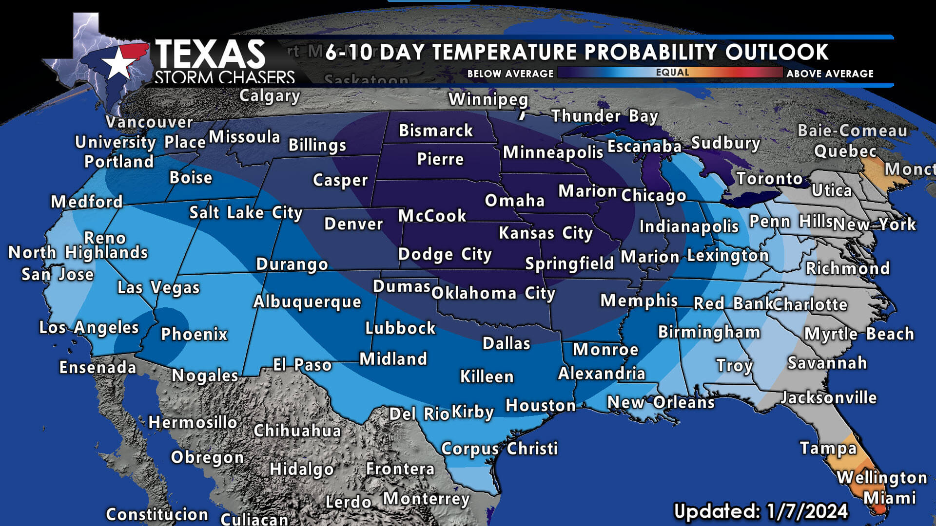
Below-average temperatures are likely across most of the United States this weekend into next week as an arctic airmass spills south.
Our next storm system arrives late this week, with active weather continuing into next week.
Busy describes the weather across Texas for the next seven to ten days. We’ve multiple upper-level storm systems with colder air arriving this weekend. Yes, the ‘S’ word may become more common than just the Texas Panhandle by early next week. Yes, the coldest weather so far this winter looks likely. No, this upcoming cold stretch will unlikely hold a figurative candle to February 2021. It’s winter, and we’re going to have cold snaps. Yes, some of those cold snaps will be rather unpleasant.
February 2021 was a generational event with a snow/ice cover across all 254 counties and an arctic high pressure setting up shop across the state. Those ‘very cold events’ tend to happen once every ten years. Sadly, human factors (mainly the millions without power or heat) made it into a humanitarian disaster, and something many have post-traumatic stress over. I want to be clear. If I thought, or begin to think, any upcoming event could bring those levels of impact, I would say so. That will apply to anything over the next couple of weeks.
Texas Storm Chasers. David ….Thank you!
Anne Burkett how are you doing today 🌹🌹🌹
I want to know if you said that in Dak’s voice.
Mary Kay Sartor how are you doing today 🌹🌹🌹
Thank you for always being here
Deej Deej how are you doing today 🌹🌹🌹
“Spinny skinny doom dooms” 😂
Thank you for the calming words and for putting this next event into perspective. I’ve lived 61 years, all in Texas, and I’ve seen some frightening, awe-inspiring weather. I thought I’d seen the worst during the 500 year flood here in Abilene in 2002, which was devastating. February 2021 was so much bigger and even deadlier, and has left many with PTSD. I never want any of us to endure such an extreme event again, but I’m afraid we will.
Raining bad here and thunder now
We went from nothing to catch up in a few days lol