
Last week I mentioned that with summer upon us the only way we’d typically see a change from the ‘hot, humid, with popup afternoon storms’ is with a tropical system. Well, I guess we may be going down that path later this week. Yeah, that’s my bad.
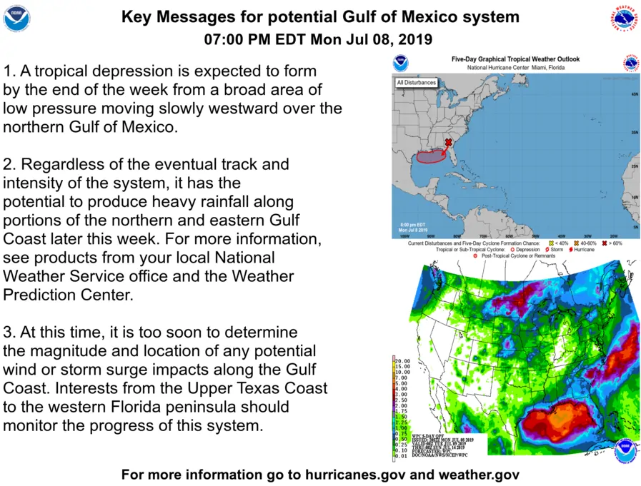
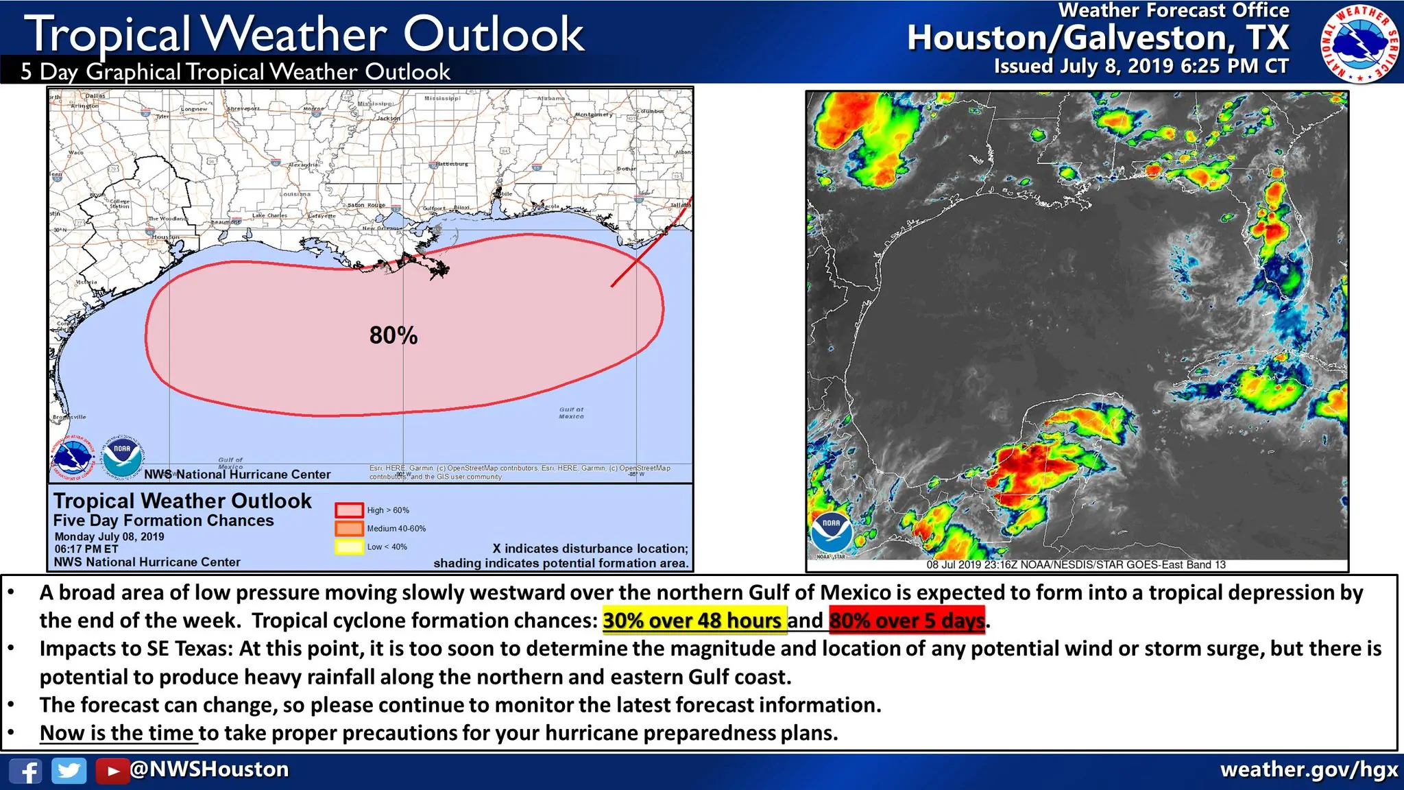
The first thing I want folks to realize is that all of what we’re about to discuss is *potential*. A tropical cyclone has not formed, at least yet, in the Gulf of Mexico. Until we have a system that has developed we’re going to have real limits on what we know and what we don’t know. Nevertheless, there are a few tidbits of information we think we know, or at least have a grasp on. Much of this information comes from the National Weather Service in Houston and their excellent forecast discussion issued this afternoon. I’ve tweaked some of the wording to make it readable for those who couldn’t give two hoots about weather nerdiness.
- Weather models are in decent agreement on the upper-level pattern as well as the evolution of any development of ‘our tropical mischief’ through Wednesday and Thursday.
- The forecast has leaned toward more of a westward track solution compared to yesterday. That would increase the potential level of impacts to Texas, especially Southeast Texas.
- Potential impacts may begin as soon as Friday if the system develops and moves toward Southeast Texas. Likewise, those impacts could peak Saturday night through Sunday.
- Upper-level winds are favorable for the development of a tropical system Wednesday through Friday.
- Water temperatures in the Gulf of Mexico are downright toasty – quite supportive of the development and intensification of a tropical cyclone (but wait, there’s more below you should read before assuming that means we automatically get a hurricane).
On the other side of the spectrum – here are a few tidbits we simply don’t know or have extremely low confidence on.
- We’re not sure how close to the coastline this potential system may develop.
- The closer to the coast the less time/less chance it has to become well organized.
- This is something we simply won’t know until the system actually develops. Even weather models, which certainly do have their own assumptions, will not be able to grasp this potential.
- The forecast track of any potential tropical system is uncertain. Odds are for a track westward across the Gulf of Mexico. The upper-level high pressure (responsible for our hot weather this week) looks like it may weaken. If that happens, a track to the west would be more likely – thus increasing the threat to the Texas coastline (generally Southeast Texas to Lousiana) versus farther east.
- Any track/intensity guidance from weather models is extremely uncertain given that we don’t even have anything right now. That’s a hint that folks should be extremely cautious when less-responsible folks share scary-looking weather model images. Meteorologists understand how to read and understand weather models. They know the vulnerabilities and weaknesses of each specific weather model. Those in the general public do not, which is why we often see absurd weather-model graphics going viral.
- Potential impacts from this system could be wide-ranging due to the uncertainty in both the track and intensity guidance – not to mention other uncertainties listed above. The next two days will allow time for the forecast to develop and data quality to improve. The Hurricane Hunters are scheduled to begin flights on Wednesday (assuming we see development begin by that point). That’ll greatly improve weather model data quality with this potential system.
If you didn’t want to read all of the above here’s a summary: Confidence is moderate to high that a tropical cyclone (tropical depression, tropical storm, etc) may form after Wednesday. Confidence is low regarding its track and potential intensity. What does that mean folks should do?
This is a good time to ensure your hurricane preparedness plans are ready – even though this system is unlikely to become a ‘major hurricane’. Look over your emergency supplies and be prepared. If you live along the coast review your evacuation plans. Most of all? Use a verified, reliable, trustworthy source for your weather information over the next several days. The National Hurricane Center issues the official tropical cyclone forecasts. Your local National Weather Service office provides excellent hyper-local forecasts. There are also plenty of meteorologists who provide trust-worthy forecast information. Nothing is guaranteed and the next two days will determine a lot about what we know and what we don’t know going forward.
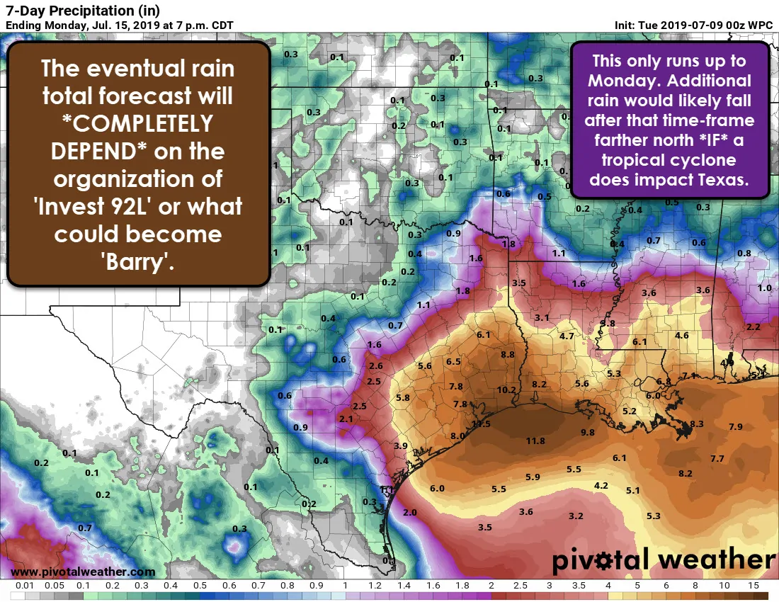
If we do have a tropical cyclone move into the region we would see a variety of potential impacts. Those would include coastal impacts and inland impacts. Those potential impacts would also include an inland heavy rain threat – well inland and away from the coast – this weekend into early next week. That would obviously result in a significant change to the forecast compared to the ongoing ‘hot, humid, chance of popup storms’ forecast. Stay aware of the forecast this week as is it will undoubtedly undergo multiple changes.


0 Comments