
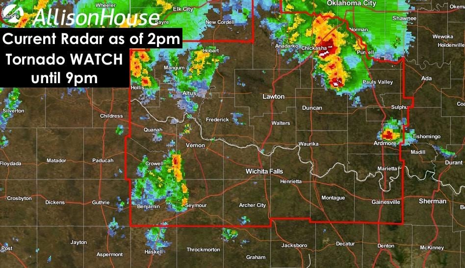
A Tornado WATCH has been issued for parts of far northwest Texas until 9pm. This includes the cities of Quanah, Vernon, Wichita Falls, Gainesville, Archer City, Seymour and surrounding communities. This does NOT include the DFW metroplex. The main threats will be from large hail and damaging winds, but due to the amount of wind shear in close proximity to a stalled warm front near the Red River, a few tornadoes are possible this afternoon and early evening within any of the more severe storms that develop. Residents within the tornado WATCH area will need to stay alert this afternoon and have a way to receive weather warnings should any be posted for your location.
NWS STORM PREDICTION CENTER NORMAN OK
   135 PM CDT TUE MAY 19 2015

   THE NWS STORM PREDICTION CENTER HAS ISSUED A

   * TORNADO WATCH FOR PORTIONS OF
     SOUTHWEST AND SOUTH CENTRAL OKLAHOMA
     NORTHWEST TEXAS

   * EFFECTIVE THIS TUESDAY AFTERNOON AND EVENING FROM 135 PM UNTIL
     900 PM CDT.

   * PRIMARY THREATS INCLUDE...
     A FEW TORNADOES POSSIBLE
     ISOLATED DAMAGING WIND GUSTS TO 70 MPH POSSIBLE
     ISOLATED LARGE HAIL EVENTS TO 1.5 INCHES IN DIAMETER POSSIBLE

   SUMMARY...SCATTERED THUNDERSTORM DEVELOPMENT WILL CONTINUE THROUGH
   THE AFTERNOON IN A MOIST ENVIRONMENT ACROSS NW TX AND SW/S CENTRAL
   OK.  ALONG A IMMEDIATELY S OF A SURFACE FRONT...ROTATING STORMS WILL
   BE POSSIBLE WITH THE RISK FOR A FEW TORNADOES...AS WELL AS ISOLATED
   LARGE HAIL/DAMAGING WINDS.

   THE TORNADO WATCH AREA IS APPROXIMATELY ALONG AND 55 STATUTE
   MILES NORTH AND SOUTH OF A LINE FROM 50 MILES SOUTHWEST OF ALTUS
   OKLAHOMA TO 80 MILES EAST SOUTHEAST OF FORT SILL OKLAHOMA.


0 Comments