
Tornado Warning for southeastern Johnson County until 815PM. Possible tornado is developing just north of Grandview on Interstate 35W. This storm is moving north at 25 MPH. Alvarado, Venus, and Grandview should be in tornado shelters! Those in the D/FW Metroplex need to monitor the progress of this storm as it approaches. Large hail and damaging wind gusts up to 75 MPH are also possible.
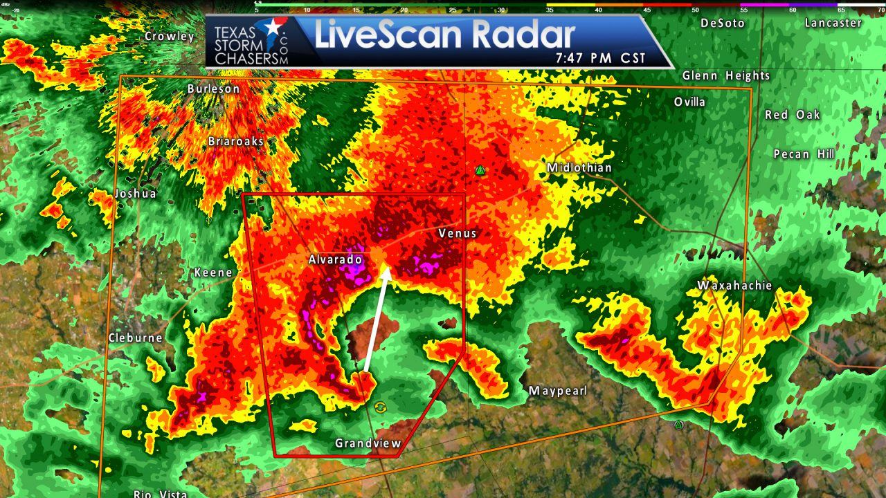
Tornado Warning
National Weather Service Fort Worth TX
745 PM CST SUN JAN 15 2017
The National Weather Service in Fort Worth has issued a
* Tornado Warning for…
Northeastern Johnson County in north central Texas…
* Until 815 PM CST
* At 744 PM CST, a severe thunderstorm capable of producing a tornado
was located over Grandview, or 7 miles south of Alvarado, moving
north at 25 mph.
HAZARD…Tornado.
SOURCE…Radar indicated rotation.
IMPACT…Flying debris will be dangerous to those caught without
shelter. Mobile homes will be damaged or destroyed.
Damage to roofs, windows, and vehicles will occur. Tree
damage is likely.
* This dangerous storm will be near…
Alvarado and Venus around 805 PM CST.
THIS INCLUDES INTERSTATE 35W between MILE MARKERs 15 and 30.
PRECAUTIONARY/PREPAREDNESS ACTIONS…
TAKE COVER NOW! Move to a basement or an interior room on the lowest
floor of a sturdy building. Avoid windows. If you are outdoors, in a
mobile home, or in a vehicle, move to the closest substantial shelter
and protect yourself from flying debris.
&&
LAT…LON 3234 9709 3226 9715 3226 9726 3246 9729
3246 9709
TIME…MOT…LOC 0144Z 196DEG 22KT 3230 9718


0 Comments