
Scattered thunderstorms are underway from the Permian Basin north through West Texas up into the Texas Panhandle. These storms are generally moving northeast at 20 to 25 MPH. The strongest of those storms have produced golfball size hail and localized damaging wind gusts. Unlike last night where storms were able to move into the eastern Texas Panhandle, we believe storms will be weakening not long after sunset tonight. Overall ingredients are not as favorable for storms to move east off the dryline. Also, we’ll see the cap quickly strengthen after 9 PM. We should be mostly storm free by the late evening. That brings us to tomorrow’s severe weather issue – which will be much more significant than today.
Before we start let me remind folks that not everyone will get rain. Not everyone will get hail. Not everyone will get high wind. Most folks will not be hit by a tornado. As always the forecast will be refined and Mother Nature doesn’t care or read the maps we draw.
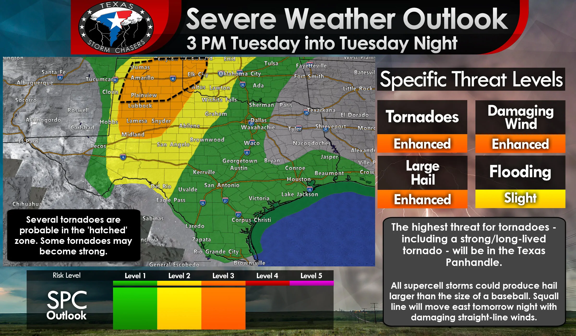
Click the image for a full-resolution version
An enhanced level 3 risk of severe weather is in place on Wednesday for much of the Texas Panhandle, West Texas, and the northeastern Permian Basin. Big Spring, Snyder, Lamesa, Post, Lubbock, Guthrie, Matador, Plainview, Dimmitt, Childress, Wellington, Shamrock, Clarendon, Hereford, Amarillo, Pampa, Borger, Dumas, Perryton, and Canadian are a few towns included. All modes of severe weather are expected, including an increased likelihood of tornadoes. Some tornadoes may be strong (EF2+) and longer-lived. These regions have about a 30 percent chance of having severe weather occur within 25 miles of any given point (like your house or business).
A level 2 risk of severe weather – the standard or “slight” risk level – includes Northwest Texas, the Big Country, Concho Valley, northern Edwards Plateau, and the remainder of the Permian Basin. Dalhart, Aspermont, Vernon, Wichita Falls, Graham, Midland, Odessa, Big Lake, Fort Stockton, Sanderson, Ozona, Sterling City, Sweetwater, Haskell, Abilene, San Angelo, Sonora, Rocksprings, and Del Rio are a few towns included.
The western delineation of this risk zone is around the approximate location of where the dryline should be set up tomorrow afternoon. You’ll note by looking at the risk graphics that there isn’t much distance between nothing and the level 1, 2, and 3 risks. That’s because once storms fire they’re going to strengthen in a hurry. That’s why we say don’t pay too much attention to the exact line placement. Pay attention if you are in or near any of the risk zones. Not to mention we’re still 18 hours out, so we’ve got several new outlook issuances to go. Those in the standard level 2 risk have a 15% chance of experiencing severe weather within 25 miles of a given point (such as your home or business).
Finally, we have the marginal level 1 risk of severe weather includes much of North Texas, Central Texas, the Hill Country, South Texas, the Coastal Plains, Coastal Bend, Brazos Valley, and Southeast Texas. I could go through a list of city names, but it’s easier to just name who isn’t in one of these risks for tomorrow. The Borderland, Northeast Texas, and East Texas are not in an official severe weather risk for Tuesday, Tuesday Night, or early Wednesday Morning.
Here are regional maps of the severe weather risk for tomorrow and tomorrow night. Each graphic can be clicked on for a full-screen version.
Tomorrow’s Storm Timing and Discussion
The level 1 risk for South Texas, Central Texas, the Brazos Valley, and Southeast Texas tomorrow afternoon is for ‘popup’ storms that could produce localized damaging winds and some nickel to quarter size hail. Those storms won’t last long and should be dissipating by sunset. We note that those in Northeast Texas and East Texas will have a risk of severe storms after sunrise on Wednesday as a line of storms rolls in from the west.
Our main focus for a more sustained severe weather tomorrow will be back west on the dryline from the Texas Panhandle south through West Texas and into the Permian Basin. Scattered supercelluar thunderstorms will begin developing after 3 PM just east of the dryline. We’ll also have to watch for thunderstorm development near residual outflow boundaries that are left over from the storms tonight. Those outflow boundaries could let storms fire up a bit farther east of the dryline and in a more moisture-rich environment. Storms will generally be moving northeast around 30 MPH. Right-moving supercells, or those that turn right, will likely move more east/northeast at around 20 to 25 MPH. Likewise, any left-splitting storms could race north/northeast closer to 40-45 MPH.
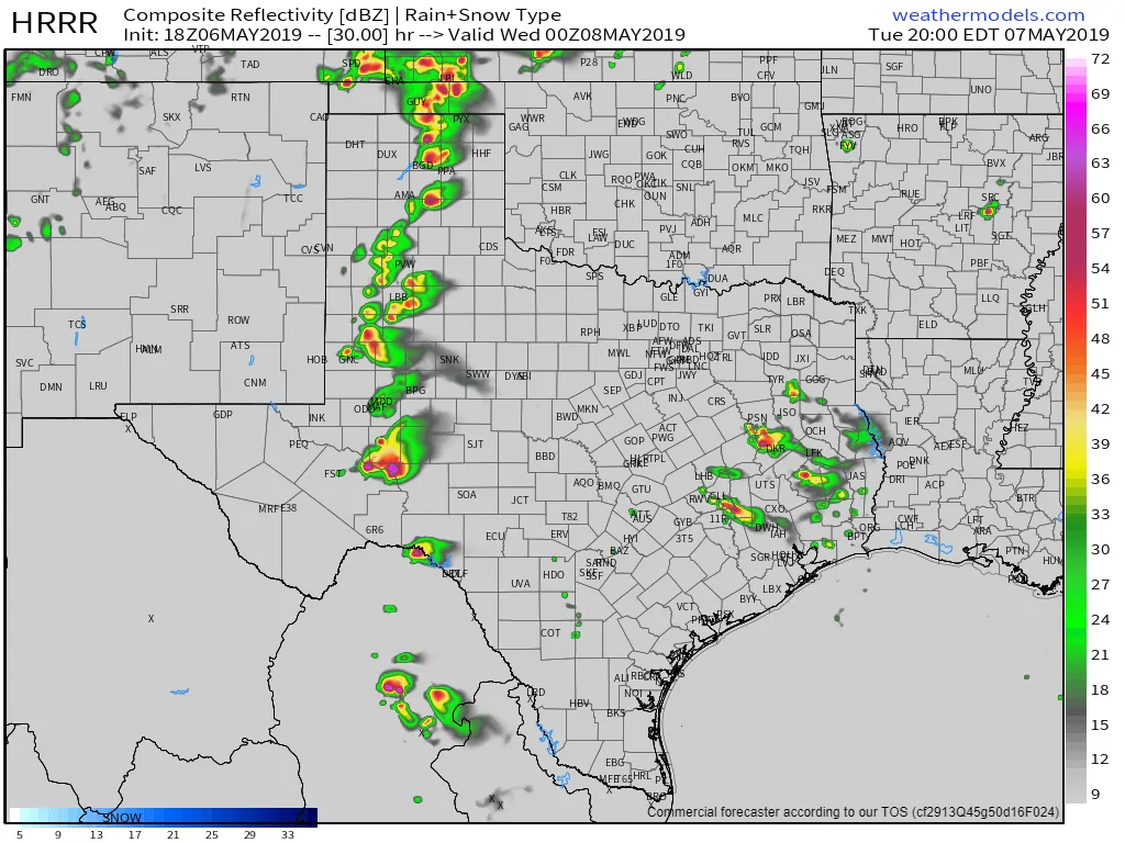
18Z HRRR Model at 7 PM Tuesday. ***THIS IS ONLY ONE MODEL’S SIMULATION. DO NOT USE AS AN OFFICIAL FORECAST***
Initial storm modes will likely be supercelluar. The strongest storms tomorrow afternoon into the early evening hours could be tornadic and nasty hailers. Tornadoes, hail larger than the size of a baseball, and localized wind gusts over 75 MPH are expected with the strongest storms in the Texas Panhandle, West Texas, and Permian Basin. The highest chance for tornadoes will be in the Texas Panhandle and West Texas where low-level wind shear will be strongest in conjunction with the lowest cloud bases.
I cannot rule out a strong tornado from 6 PM to 9 PM in the eastern half of the Texas Panhandle. The extent and duration of the tornado threat tomorrow will be dictated on storm mode. Specifically, the threat of tornadoes will continue until storms grow upscale into clusters of a squall line. Even then the threat for brief tornadoes will co-exist with damaging straight-line winds as a squall line moves east/southeast tomorrow night.
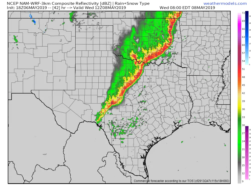
18Z North American Model (3KM) at 7 AM Wednesday. ***THIS IS ONLY ONE MODEL’S SIMULATION. DO NOT USE AS AN OFFICIAL FORECAST***
That squall line is going to make a mess of things tomorrow night and into Wednesday as it moves east across a relatively large chunk of Texas. We’ll have to see exactly how quickly the line becomes organized as it’ll accelerate eastward. Timing of arrival for specific locations will thus depend on that organization along with a few other factors. The North American Model has the squall line in Texoma, western North Texas, southwestward into the Concho Valley and Edwards Plateau by 7 AM Wednesday. That may be a bit too slow if the squall line is moving more quickly, which they tend to do if they become well organized.
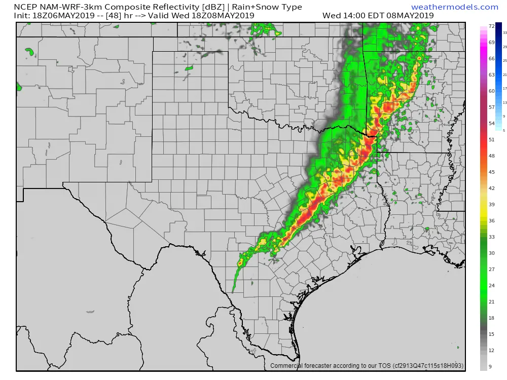
18Z North American Model (3KM) at 1 PM Wednesday. ***THIS IS ONLY ONE MODEL’S SIMULATION. DO NOT USE AS AN OFFICIAL FORECAST***
The same weather model has the line of storms near Texarkana southwest to Longview to Fairfield to Austin around lunch-time Wednesday. I expect some storms would still be capable of producing damaging winds and perhaps some quarter size hail. We’d also have to watch for a quick 1 to 2 inches of rain. This line plays an important rule in the potential for severe thunderstorms Wednesday afternoon – or perhaps helping to mitigate a higher-end severe weather event.
The airmass behind the squall line on Wednesday is going to be worked over. By Wednesday afternoon moisture values will be comparatively lower, the atmosphere will be less unstable, and low-level winds will be ‘muddled’ or not particularly impressive. Before this line looked probable we were expecting a volatile airmass with strong wind shear to be in place near Interstate 35 by Wednesday afternoon. That now does not look to be likely. There will be some recovery, especially if storms are able to move out quickly and we get clearing. That scenario would allow for a few severe storms to redevelop by early Wednesday evening in North Texas. Those storms could be hailers.
Multi-Day Heavy Rain Event starts Thursday and continues into the weekend
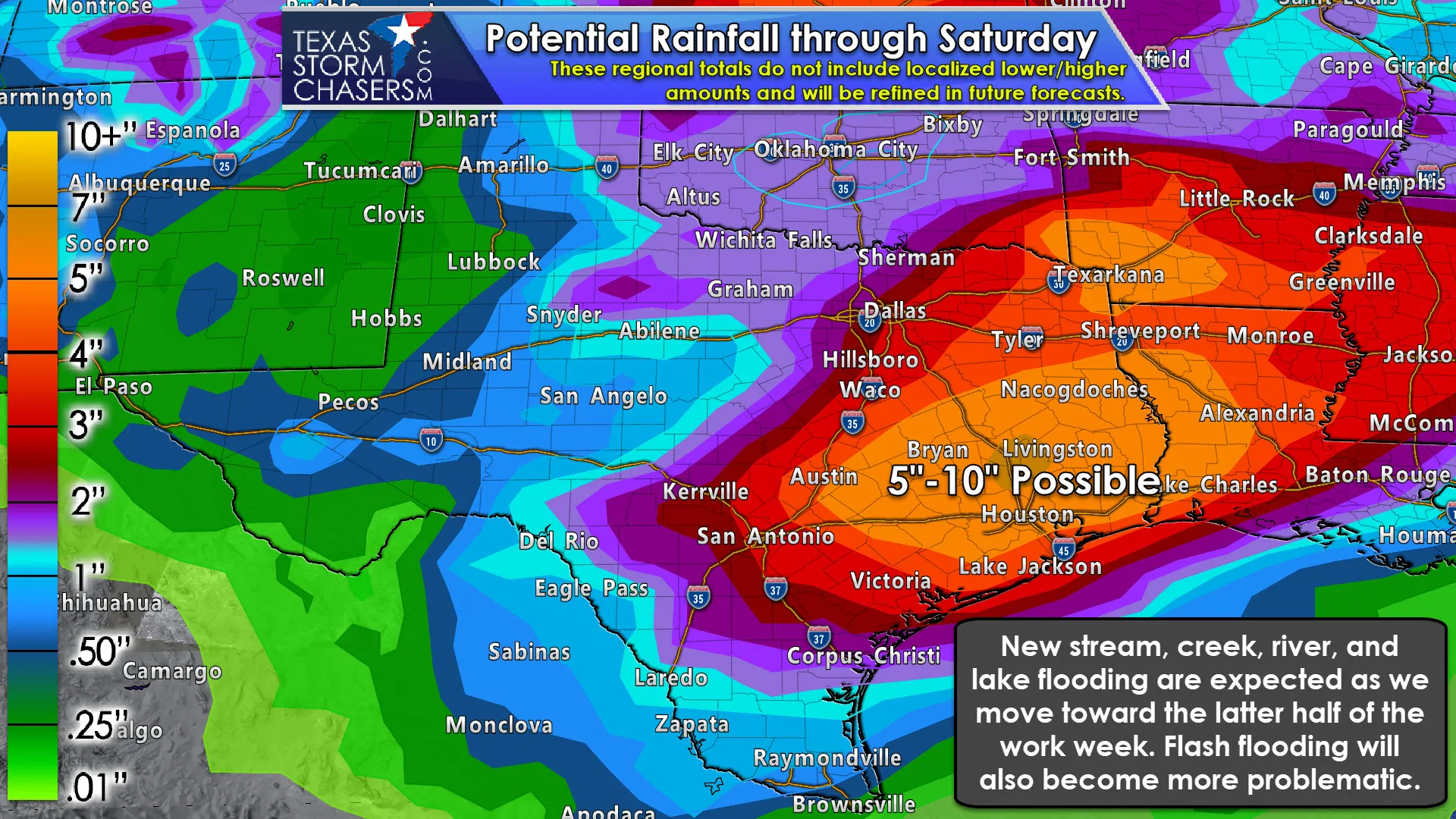
Click image for full-screen resolution.
A cool front will move south on Thursday across the state. The most noticeable change will be a much drier airmass with much lower humidity values and impressively cool overnight temperatures for May. In other words, it’ll feel more like early April versus May. That cool front is going to stall out in Southeast Texas and South Texas on Thursday – and stick around until at least Saturday. Abundant moisture values along and south of the front, several waves of upper-level lift, along with the front itself will allow for multiple rounds of heavy rain. Saturated soils in conjunction with all that moisture will allow for a fairly impressive rainfall event to unfold over a period from Thursday through Saturday.
We’ll refine the exact corridor of heaviest rainfall and hope we can keep totals in the 3 to 5-inch range. Some folks in the Brazos Valley, Southeast Texas, and East Texas are probably going to end up getting closer to 10 inches of rain by the time all is said and done. As you might expect that kind of rainfall, even spread out over several days, will cause a significant rise in creeks, streams, rivers, and lakes. If we see several inches of rainfall in a ‘hours’ versus ‘day’ timespan we’ll also see flash flooding occur. Again, we’ll deal with that issue once we get past tomorrow and tomorrow night.


0 Comments