
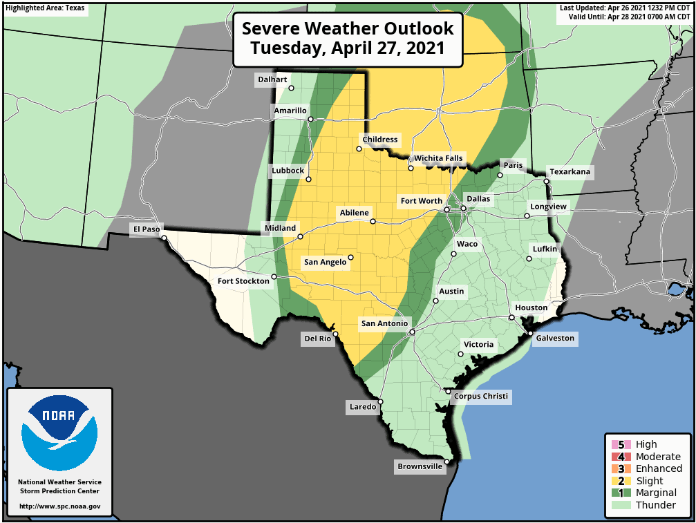
The Storm Prediction Center has highlighted a risk of severe thunderstorms Tuesday afternoon and Tuesday night across portions of Texas. A level one and level two risk of severe thunderstorms include the eastern Texas Panhandle, West-Central Texas, the eastern Permian Basin, Northwest Texas, Big Country, Concho Valley, the Edwards Plateau, western North Texas, and Texoma.
Severe thunderstorm risk levels convey the potential coverage of severe storms. A level one risk is the lowest, while a level five is the highest. Not everyone will have severe storms in their area tomorrow. Learn more about the probabilities of severe weather risk levels here.
Tuesday morning will feature widespread cloud cover with drizzle/showers across much of Texas. Scattered showers and thunderstorms will develop by the early afternoon across the eastern two-thirds of Texas. Some storms may produce pea to quarter size hail. Our relatively higher threat for scattered severe storms won’t begin until Tuesday evening.
Tomorrow’s severe weather forecast is a complex one. If enough clearing can occur tomorrow afternoon, a couple of discrete supercell thunderstorms may develop in the southeastern Texas Panhandle, West-Central Texas, and into Southwest Oklahoma.
If those afternoon storms manage to get going, they could produce very large hail and pose a tornado risk. Few in number, but high in impact – so don’t come complaining that we’re hyping up something that 99% of folks won’t get hit by.
Scattered strong to severe thunderstorms are expected to develop in the eastern Permian Basin, West-Central Texas, the Big Country, and Northwest Texas tomorrow evening. We may have to wait until after 9 PM for vigorous development.
If the upper-level storm system responsible for storm chances drags its boots, we may not see stronger storms until after midnight Wednesday. The most intense thunderstorms tomorrow night may produce large hail up to the size of golfballs and localized damaging wind gusts up to 70 MPH. A tornado or two can’t be ruled out.
If enough clearing can occur tomorrow afternoon, a couple of discrete supercell thunderstorms may develop in the southeastern Texas Panhandle, West-Central Texas, and into Southwest Oklahoma. If those afternoon storms manage to get going, they could produce very large hail and pose a tornado risk. Few in number, but high in impact – so don’t come complaining that we’re hyping up something that 99% of folks won’t get hit by.
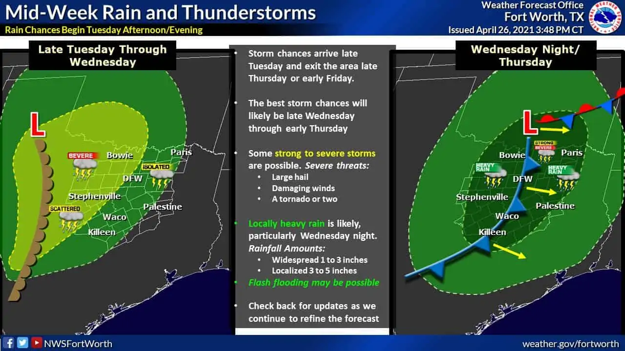
Wednesday, Wednesday Night, and Thursday will feature several rounds of rain across the eastern two-thirds of Texas. Not everyone will get rain, and it won’t constantly rain for two days. Our primary source of lift for the multi-day rain chances will be a slow-moving upper-level low. Lift from the upper-level low will start overspreading parts of Texas tomorrow. Waves of lift will continue to overspread Texas until the upper-level low gets moving late Wednesday and Thursday.
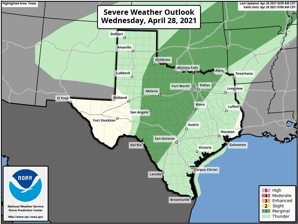
Some storms Wednesday afternoon and Wednesday evening may become strong with hail and localized damaging winds. Boundaries produced by storms tomorrow night may create a small zone of more favorable conditions for severe storms. At this time, a broad ‘level one’ risk of severe weather will suffice. We’ll keep an eye on it.
With a slow-moving upper-level storm system, we could see some hydrological issues develop Wednesday Night and Thursday. Some locations may see multiple rounds of heavier rains – producing multi-inch rainfall amounts. Localized flash flooding may develop, especially if heavier rains end up falling on urbanized locations. We need the rain, but we don’t need it all falling at once.
Rain chances will end across the eastern half of Texas late Thursday Night or Friday Morning.


0 Comments