
A significant winter storm will bring heavy snow, sleet, and freezing rain to the northern two-thirds of Texas over the next thirty-six hours. Crashy, the arctic cold front is plowing south into the Permian Basin, Big Country, and North Texas. By 10 PM tonight, the front will be near a line from Texarkana to Victoria to Laredo. Much colder temperatures and gusty north winds are ongoing behind the front. Wind chill temperatures will be frigid over the next few days.
Video Discussion
Overnight Forecast Adjustments
A few changes to the forecast have been made based on the overnight weather model data and observational trends. Not surprisingly, the cold front is running a bit ahead of schedule. With the colder air arriving a bit sooner, we’ll have to extend the threat of winter accumulations farther south. Thus, the San Antonio Metro and Bryan/College Station are now in the ‘threat zone’ for ice accumulations and hazardous road conditions beginning Thursday morning.
Timing
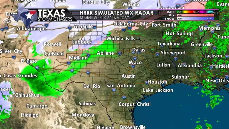
Ice accumulations are likely to result in hazardous travel conditions beginning later today across Northwest Texas, the Big Country, south into the Concho Valley. This evening, freezing rain and sleet will begin in earnest across Texoma, North Texas, Central Texas, and the Hill Country. Snow will be ongoing across the western third of Texas.
All of that precipitation will move east on Thursday, bringing several hours of heavy winter precipitation and additional accumulations. We’re expecting the precipitation to begin decreasing in intensity and coverage tomorrow afternoon. Some lighter precipitation may continue into Thursday night and Friday morning.
Ice Accumulation Forecast
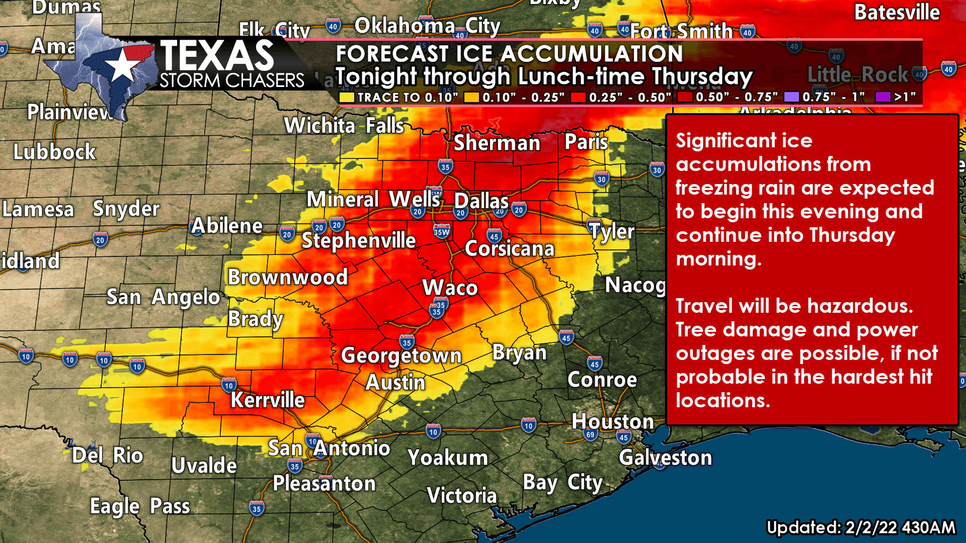
Ice accumulations up to one-half inch are possible across the northern D/FW Metroplex northeast toward Paris tonight into Thursday morning. Ice accumulations of one-tenth to three-tenths of an inch are expected south into Central Texas and the Hill Country. Gusty north winds up to 35 miles per hour combined with increased ice loading, resulting in tree damage and power outages.
Depending on the extent of the ice storm damage, some locations may be without power for several days. We’re describing ice storm damage to power infrastructure – not any ‘load event’ – that’s not our department.
Snow Accumulation Forecast
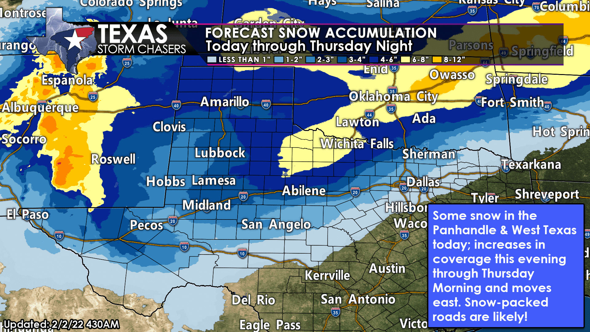
Snow accumulations of six to eight inches will be possible tomorrow afternoon across Northwest Texas, including Wichita Falls southwest to Snyder and Throckmorton. Widespread snow accumulations of two to five inches are expected across the Texas Panhandle, West Texas, Permian Basin, Big Country, Trans-Pecos, and the Guadalupe Mountains.
Lower snow totals are expected around and south of the Davis Mountains and in the Concho Valley. The eastern delineation of snow totals (northern Edwards Plateau, Hill Country, into the D/FW Metroplex to Texarkana) is likely to consist of a sleet/snow mix. Up to two inches of sleet may accumulate – which would likely bring a return of the December 2013 ‘Cobblestone Ice.’
Temperatures through the Weekend
Daytime high temperatures will try and sneak above freezing on Friday, but we’re probably going to have to wait until Saturday for most locations across Texas. Overnight low temperatures will be frigid for folks with significant ice and snow cover. Low temperatures will range from the negative single digits in the Panhandle to the middle teens Friday morning in North Texas and the Concho Valley. Single digits and teens are likely Saturday morning across the northwest half of Texas.
Temperatures will be a bit warmer overnight across the southeastern half of Texas both nights, but freezes are still likely. While cold, the temperature records set last February (both in how cold and how long it stayed below freezing) are not in jeopardy whatsoever. We’re dealing with a two to three-day cold snap with temperatures returning to the 60s early next week. We were below freezing for the better part of a week last February.


0 Comments