
This week, a warmer and wet weather pattern is setting up for a deluge across Texas. After a drier-than-a-popcorn fart of a late fall, winter has been busy. That’ll be the case again over the next seven days, at least. We remain chilly across the state, though signs of change have already begun. Moisture is flowing into Texas from the Gulf of Mexico; warmer temperatures will soon follow. That’ll become quite apparent beginning Monday and continuing through the work week.
Let’s understand why we’re gracing you with an extra Texas Weather Roundup. Numerous showers and thunderstorms are expected across the eastern half of Texas tonight through Tuesday morning. We’ll be safely above freezing for most of that region, with no winter precipitation expected. This evening through early Monday morning, there will be a period where freezing rain is expected in Texoma, the Ark-La-Tex, and parts of North Texas.
Icy Mischief Tonight?
Temperatures will slowly climb after midnight through Monday’s pre-dawn hours as warm air advection overcomes the typical diurnal temperature curve. Temperatures should rise above freezing in North Texas and on our side of the Red River by sunrise tomorrow.
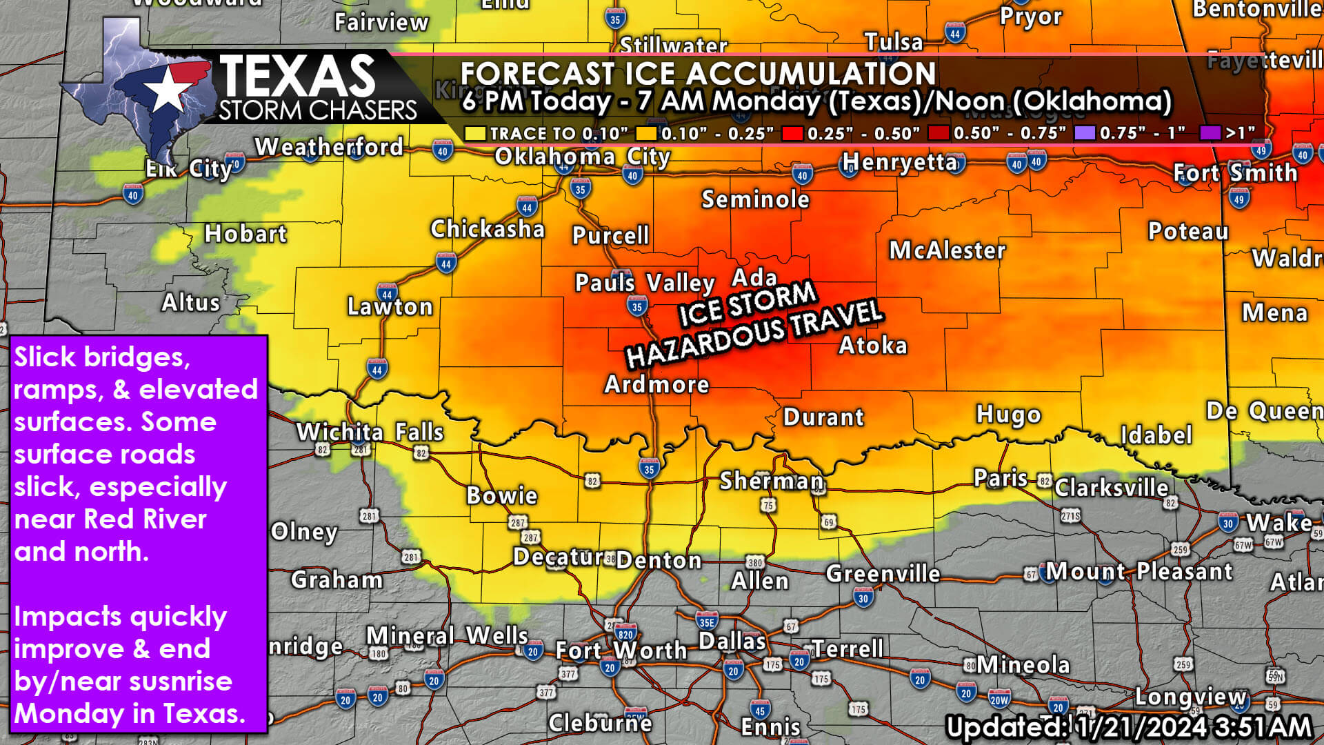
A trace to one-tenth of an inch of ice accumulation is possible this evening through early Monday morning north of a line from Wichita Falls to Graham to Rhome to Denton to McKinney to Wolfe City to Clarksville. Impacts to travel, especially on bridges and elevated surfaces, are expected this evening through early Monday morning. This threat does include the northern D/FW Metroplex. It will be a close call, though. If temperatures are a degree or two colder, the entire metroplex may see light icing on elevated surfaces tonight, back into the Big Country.
The saving grace preventing a full-fledged ice storm is that temperatures will slowly rise overnight and climb above freezing by 7 AM Monday. The same can’t be said for the eastern half of Oklahoma and Arkansas – where more severe impacts are expected to continue through midday Monday. Travel north of the Red River is not advisable this evening through lunchtime Monday.
Rain will continue on Monday across the eastern half of Texas. That rain will help accelerate ice melting after temperatures rise above freezing, resulting in rapid improvements from any ice-related travel difficulties. Travel issues caused by wet roads and drivers? Eh, we’re doomed.
Deluge Ahead for Texas
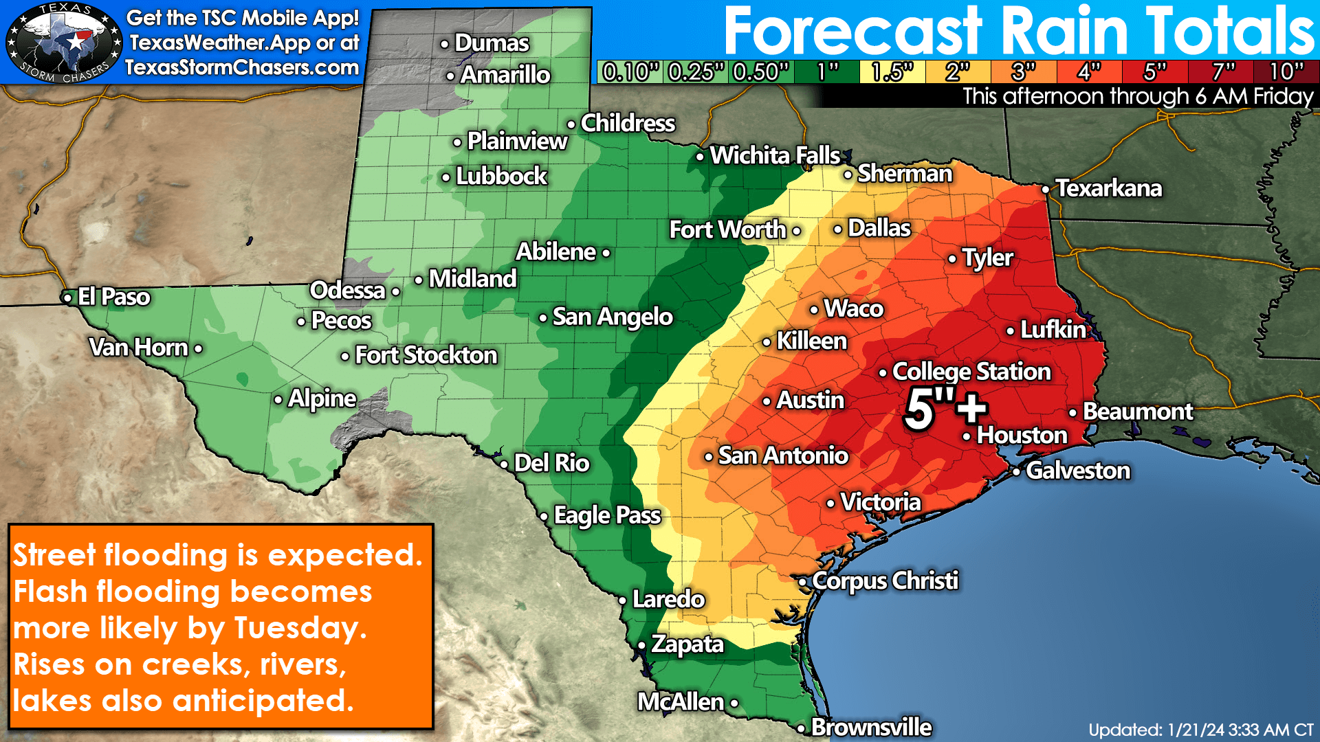
Monday, Tuesday, and Wednesday will be wet across the eastern half of Texas. We’re looking at several inches of rainfall expected. Five to seven inches of rain are possible by Friday morning in the Ark-La-Tex, East Texas, Southeast Texas, Coastal Plains, up into the Brazos Valley. We expect at least one to three inches of rain across the eastern half of Texas, from Texoma south through the Hill Country and South Texas. Rainfall amounts of one-half to over one inch are possible in Northwest Texas, the Big Country, Concho Valley, and Edwards Plateau.
At least one-tenth of an inch of rain is expected in the eastern Panhandle, West Texas, Permian Basin, into the Big Bend, Trans-Pecos Region, and the Borderland of Far West Texas. It looks like we’ll remain active with precipitation chances into next weekend. Some threat for stronger storms may materialize in South Texas and near the Texas Gulf Coast by Tuesday. This week’s deluge will also result in a risk of flooding, especially by Tuesday across eastern regions. It’s a great time to check out our free mobile app and bookmark our free interactive weather radar!

Good morning, have a great day! 36 degrees in Denton/Corinth and cloudy ☁️
Solid thumbnail
Jacob Calderon thank you
Send it to Lake Leon
No!!! Rain for 3 days??! My dogs hate going out in the rain to pee!
Lauren Layton yepp
Lauren Layton mine too. She goes into deep depression when it rains!
We are so saturated!!!
We want to give a huge shout-out to the top Stars senders. Thank you for all the support!
Leslie Herrington Jager, Vee Anne Miller, Diane Day Thompson, Rene Pardue DelToro, Cheryl Kort, Khisha Kelley Harris, Jim Doherty, Wendy Daum, Kathy Story, Stephanie Mullins Letson
Crazy but typical Texas
Well, only if you promise the wind will stop. Never like that side of the family!
Bill