
Precipitation has calmed down overnight, and we’re in the midst of a lull this morning. At the time of this writing (5 AM), we have showers in the northeastern Texas Panhandle and Far Southeast Texas. Up to six inches of rain fell last evening from Nacogdoches and Lufkin east to San Augustine and Hemphill. Flooded roadways, streams, and creeks will continue to be an issue today, even if there are no additional rainfalls.
There will be multiple chances for showers and thunderstorms later today, tonight, Tuesday, and Wednesday across the eastern two-thirds of Texas. I encourage you to check the National Weather Service or your phone’s weather app for specific rain chances in your neighborhood. Our focus with this morning’s discussion will be on the potential for severe thunderstorms this afternoon, and to a lesser extent, tonight.
Most of Texas will see rain chances increase late tonight and tomorrow – with a low-end severe weather threat continuing. Some localized flooding will also become an increasing hazard tomorrow and on Wednesday.
Today’s Severe Weather Outlook
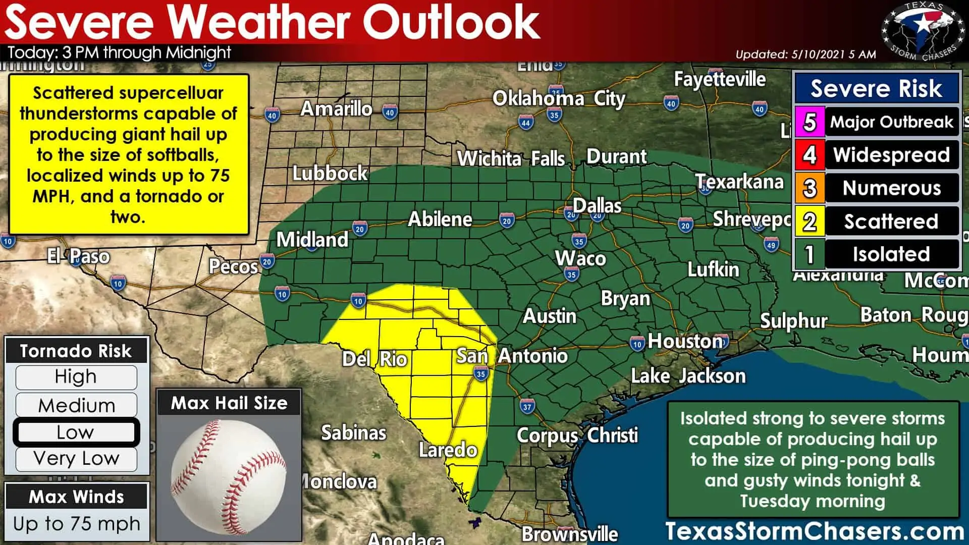
A relatively large level one risk of severe weather is in effect this afternoon through early Tuesday morning. The risk zone runs from the Permian Basin and West-Central Texas eastward to Northeast Texas and Southeast Texas. Those within the level one risk zone could see isolated stronger storms in their vicinity late today and tonight. Most activity will not be severe, but some storms may produce pocket-change size hail and gusty winds.
Our focus for more significant severe weather potential will be in the Edwards Plateau and Rio Grande Plains this afternoon through the mid-evening hours. Those two regions are where the Storm Prediction Center has highlighted a level two risk of severe weather. Remember, severe weather outlooks are based on the probability of severe storms within 25 miles of any given point. Those outlooks don’t necessarily equate to severe weather intensity.
Timing and threat details
Scattered supercelluar thunderstorms are likely to develop after 2-3 PM in northern Mexico and the Edwards Plateau and southern/western Hill Country. A very unstable airmass is expected to be in place along with supportive upper-level wind shear. Those living in the region won’t be surprised to hear it after the last two weeks, but yes, today’s most intense storms could produce very large to giant hail.
More specifically, an intense supercell may be capable of producing baseball to softball size hail. Localized wind gusts up to 75 MPH, and a tornado or two are also threats. I encourage those on the west side of San Antonio to keep a vigilant eye out late this afternoon. High-resolution weather models (as I’ll show below) are trying to bring a nasty supercell toward town.
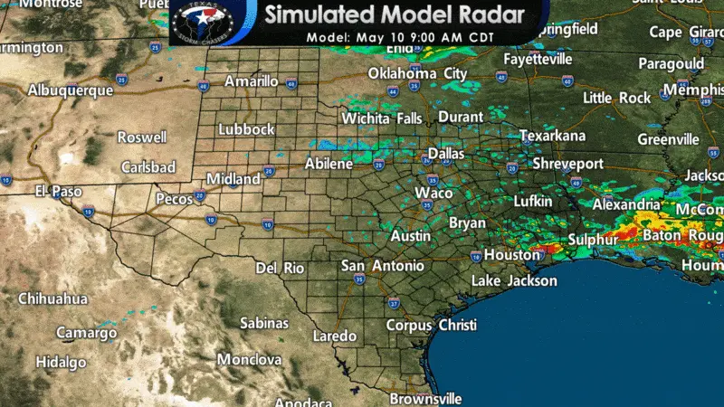
Simulated weather model radar from lunch-time today through Tuesday morning
The High-Resolution Rapid Refresh (HRRR) has storm intensity and coverage increasing after 2 PM. Storms will generally move to the east, but right-movers should move more southeasterly. Today will be a situation where an intense storm won’t impact most folks, but it is a case where you better be ready. There will probably be some nasty, nasty hailers this afternoon in the Edwards Plateau. Low-level wind shear will be weak, but may locally be enhanced in proximity to any boundaries or the cool front. A tornado cannot be ruled out.
Storms could continue through the mid-evening hours, with some continuing to near midnight. Meanwhile, showers and thunderstorms will increase in coverage tonight across a majority of Texas. Most activity tonight will not be severe, but any storms will be capable of producing cloud-to-ground lightning and heavy rainfall. A few storms may become strong to marginally severe with hail up to the size of ping-pong balls.
Tuesday’s Severe Weather Outlook
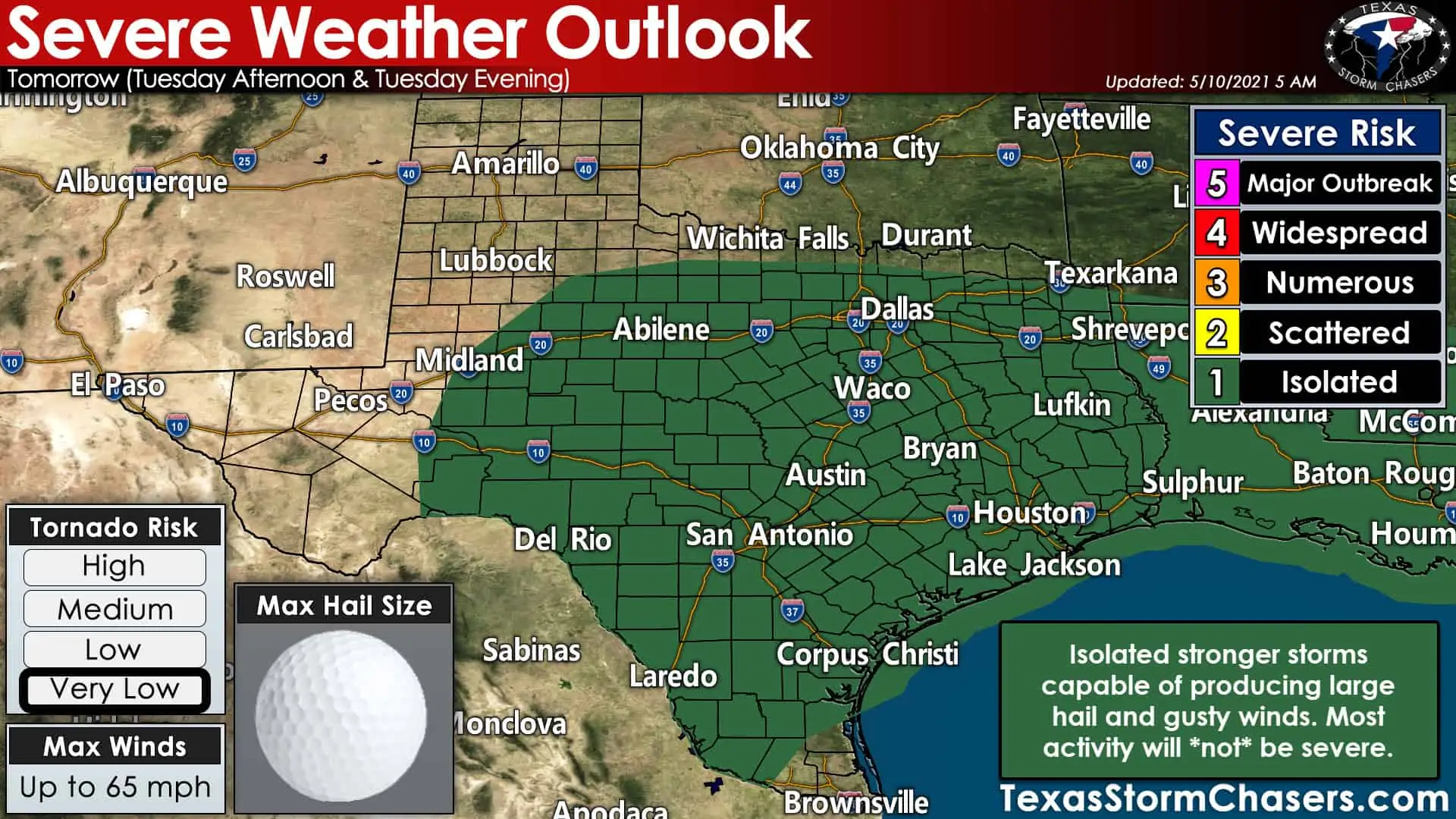
Tuesday could be wet at times across nearly all of Texas. There is a level one risk for stronger storms with hail tomorrow. We may see a smaller corridor of higher severe thunderstorm potential develop, but those details are fuzzy at this point. Any heightened threat for hail tomorrow will depend on how tonight and tomorrow morning unfolds. Don’t be surprised if we see a level two risk for hail added in future updates.
Rain Totals and Flooding Threat
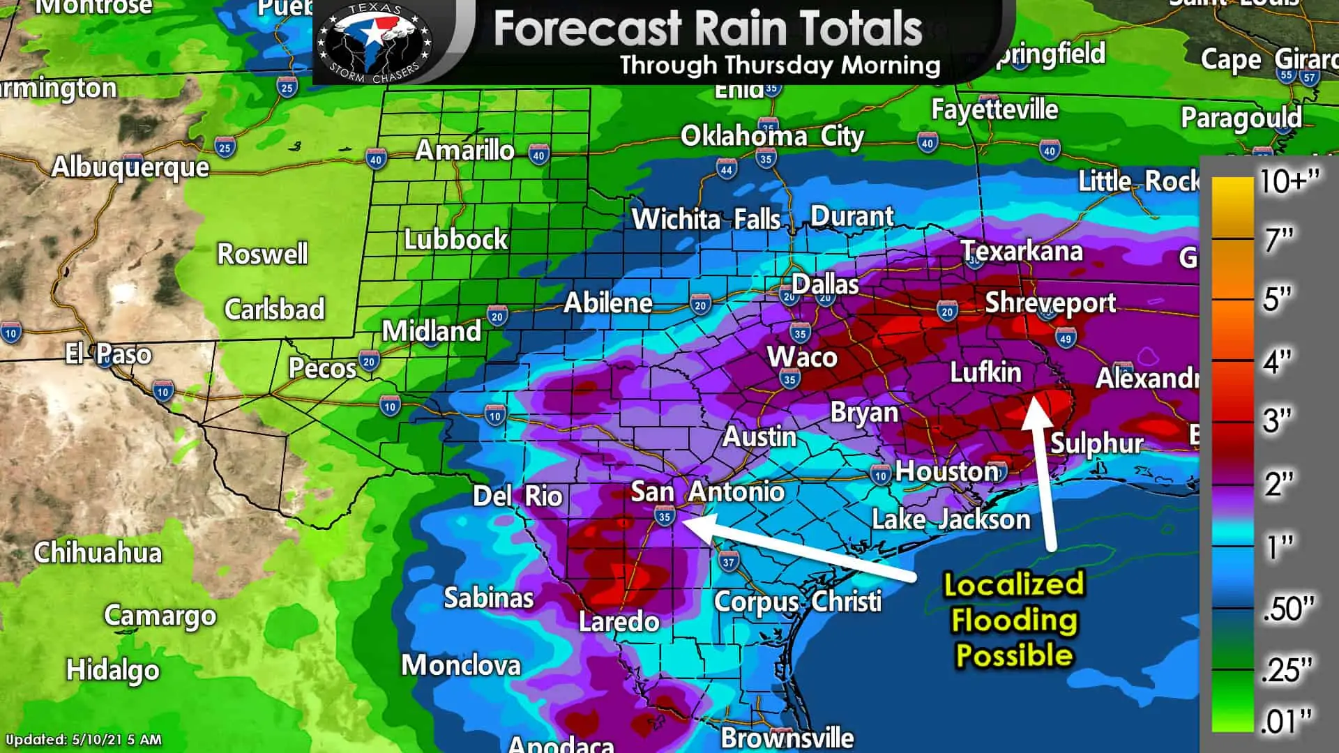
I won’t take too much about rain totals or hydrometeorological concerns this morning. However, we’re expecting a decent soaker over the next couple of days. The forecast rain totals shown above run through Thursday Morning from the Weather Prediction Center. We will have to watch for localized higher amounts approaching five to six inches. Just like last night around Lufkin, we’re expecting more localized flooding problems – especially Tuesday morning through Wednesday.
On the bright side? Temperatures will be downright cool for mid-May for folks north of a cool front. One reason we’re keeping an eye out for some spotty hail tonight and tomorrow is that a warm, unstable air mass remains aloft. Our cool front is shallow and only extends the surface to a few thousand feet up. Above that, plenty of moisture and instability remains to support precipitation.
This evening, I’ll put a discussion out with a more detailed look at rain chances on Tuesday and Wednesday – along with any concerns over flooding.


0 Comments