
The Groundhog Day Winter Storm of 2022 is underway across Texas. Accumulating winter precipitation is ongoing across the southern Permian Basin, Concho Valley, Big Country, Northwest Texas, and North Texas. Temperatures are falling below freezing in the D/FW Metroplex. Rain will change over to freezing rain and sleet across D/FW over the next couple of hours. As temperatures continue to drop, roads will start freezing up. The same story will play out later tonight and Thursday morning across the Hill Country, Central Texas, northern Brazos Valley, and portions of Northeast Texas.
For a video update on tonight’s expectations, click here.
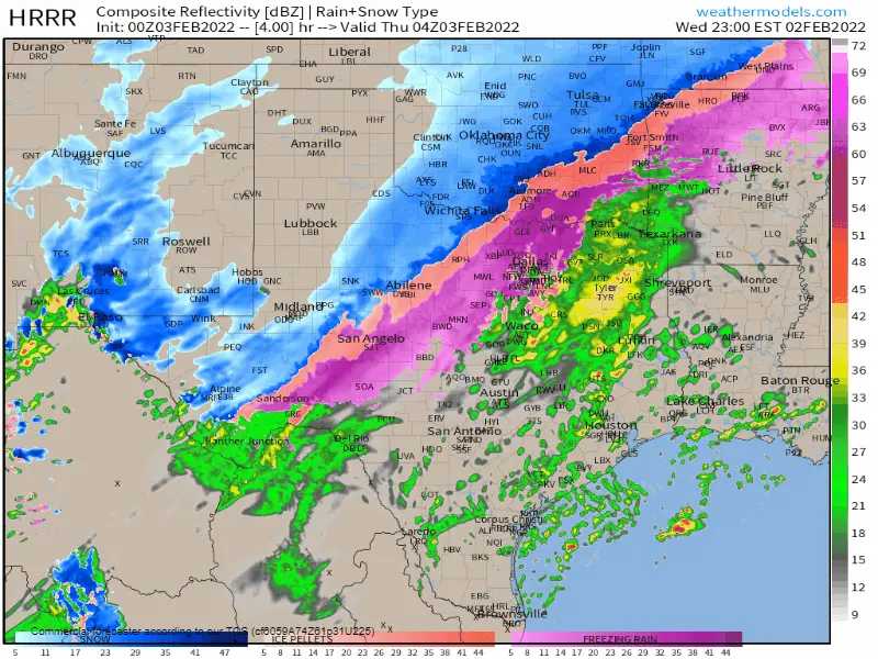
Precipitation will continue tonight as surface temperatures drop. We expect winter precipitation and travel issues to expand down Interstate 35 through Central Texas and toward the north side of the San Antonio Metro in time for the morning commute. Please forgive me for not being more articulate with my words; it’s been a long day. I hope the animation above can provide a sense of timing for your specific location. Otherwise, we anticipate the northern half to the northern two-thirds of Texas to have winter weather by Thursday morning or early Thursday afternoon.
A significant ice storm is anticipated tonight and on Thursday across Texoma, North Texas, Central Texas, and the Hill Country. Freezing rain accumulations may approach a one-half inch in some locations. Sleet and snow accumulations in the regions mentioned above may exceed two inches. If freezing rain is the primary precipitation type, we anticipate tree damage and a substantial risk of power outages due to lines coming down. If sleet is the primary precipitation type, we’ll see ‘cobblestone’ ice on roadways but less of an impact on trees and powerlines.
All winter precipitation types will produce hazardous road conditions, but we’d prefer snow and sleet over freezing rain. We’re going to be in real trouble if freezing rain is our primary precipitation type tonight – since we’re going to have a considerable amount of ice accumulate on powerlines and trees.
Snow, mixed with sleet, is falling in Northwest Texas south into the Big Country and Concho Valley. That activity will spread east overnight into the regions described above. We expect another round of snow to bring another one to four inches of accumulation to the Panhandle, West Texas, and Northwest Texas on Thursday.
Precipitation will decrease coverage and intensity over the northwestern two-thirds of Texas tomorrow afternoon. It now appears like we could see some icing impacts Thursday Night into Friday morning across South-Central Texas, the Middle Texas Coast, the Coastal Plains, and Southeast Texas. Tomorrow night’s threat does include Corpus Christi north to Beeville and up Highway 59 into the Houston Metro. Accumulations of ice would be light but would undoubtedly be enough to cause slick bridges and overpasses.
Precipitation will conclude on Friday across all of Texas. We’ll start warming up Friday afternoon. However, the hardest-hit folks may have to wait until Saturday afternoon to climb above freezing. Friday and Saturday morning will be frigid across Texas.


0 Comments