
We’re expecting a gradual uptick in both thunderstorm coverage and intensity this afternoon across North Texas. The storm prediction center has indicated they will likely issue a severe weather watch in the next couple of hours. The strongest storms may produce large hail, damaging winds, and a low-end tornado threat. Stay weather aware!
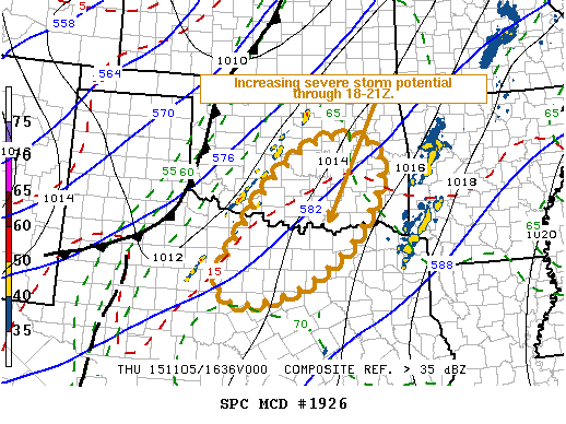
NWS STORM PREDICTION CENTER NORMAN OK
1048 AM CST THU NOV 05 2015
AREAS AFFECTED…N CNTRL TX INTO S CNTRL/ERN OK
CONCERNING…SEVERE POTENTIAL…WATCH LIKELY
VALID 051648Z – 051815Z
PROBABILITY OF WATCH ISSUANCE…80 PERCENT
SUMMARY…THE RISK FOR SEVERE STORMS IS EXPECTED TO INCREASE ACROSS
PARTS OF THE SOUTHERN INTO CENTRAL PLAINS…PARTICULARLY ACROSS
PARTS OF NORTH CENTRAL TEXAS INTO SOUTH CENTRAL AND EASTERN
OKLAHOMA…DURING THE 18-21Z TIME FRAME. THIS WILL INCLUDE
POTENTIAL FOR LARGE HAIL…ISOLATED TORNADOES…AND EVENTUALLY AN
INCREASING RISK FOR DAMAGING WIND GUSTS.


0 Comments