
Severe thunderstorms are likely on Monday and Monday night in several regions of Texas. Compared to yesterday’s forecast, we’ve seen a substantial shift west due to a slower progression of the upper-level storm system. Given the slower trends, the threat for severe thunderstorms has expanded west tomorrow. I’ll go over the new severe weather outlook in detail. The danger for severe storms is conveyed using the probability of a severe storm within twenty-five miles of any given point. Level one is the lowest risk, while level five is the highest. The higher a risk level, the more uncommon it becomes and the higher the chance of severe storms in your immediate area.
Monday’s Severe Weather Outlook
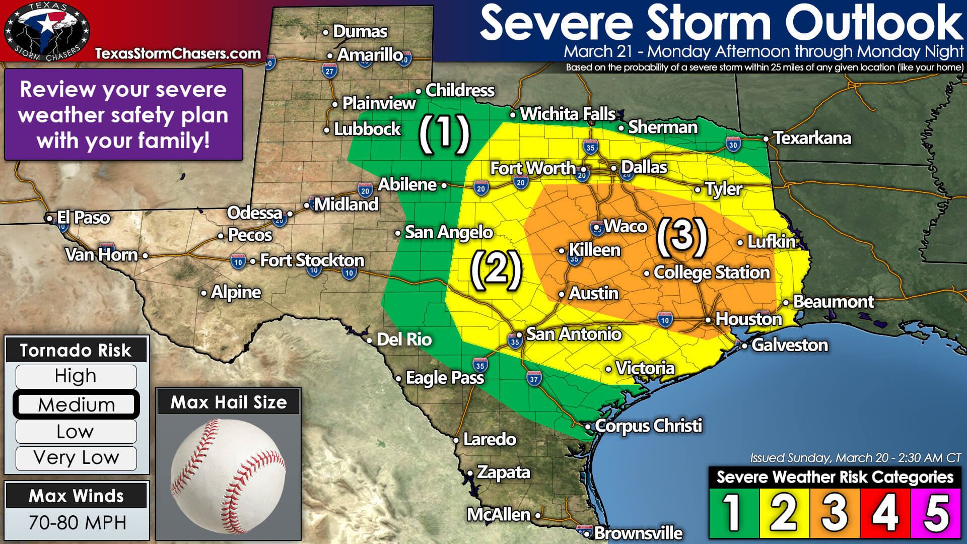
Risk Levels
Level 1 out of 5: Northwest Texas, Texoma, Northeast Texas, Big Country, eastern Concho Valley, South Texas. 5% chance of severe storms within 25 miles of any given point, such as your home.
Level 2 out of 5: North Texas, Hill Country, South-Central Texas, Coastal Plains, Golden Triangle, Piney Woods of Far East Texas. 15% chance of severe storms within 25 miles of any given point, such as your home.
Level 3 out of 5: Southern North Texas, Central Texas, Brazos Valley, Southeast Texas, parts of East Texas. 30% chance of severe storms within 25 miles of any given point, such as your home.
There are no level 4 or level 5 risks outlined at this time. I would not be surprised to see a small level 4 risk added in later outlooks once confidence increases in a particular forecast solution. A level 4 risk would have a 45% chance of severe storms within 25 miles of any given point, such as your home.
You can view Monday’s latest severe weather outlook, meteorological discussion, and hazard-specific probabilities here.
Threats
All modes of severe weather are possible on Monday and Monday Night. Damaging hail up to the size of baseballs, straight-line winds over 70 miles per hour, and a few tornadoes are all hazards. A significant, long-track tornado may occur, especially within the level 3 risk zone. Not all storms will produce the threats mentioned above. Storms tomorrow will be moving very quickly, leaving less time to take action. Severe weather will continue most of tomorrow night in some regions.
Timing & Discussion
Showers are possible by sunrise Monday from West Texas eastward across the Interstate 35 corridor. Heavier rain and thunderstorms are expected by lunch-time across Texoma, North Texas, and Central Texas. The following scenario describes what most weather model data is indicating this morning. I fully anticipate changes to the narrative as we continue to get closer to Monday, but here’s how the event may play out.

Simulated weather model radar on Monday from the overnight run of the High-Resolution Rapid Refresh (HRRR) model. This is only a guesstimate, and data will undoubtedly change in future runs.
While some storms may produce small hail and gusty winds, this early afternoon activity looks to behave. As the atmosphere destabilizes across Central Texas by mid-afternoon, more intense thunderstorms may begin developing. These storms should initially be discrete – and capable of producing all modes of severe weather. Storms will be moving northeast at 50 to 55 miles per hour.
Storms may grow upscale into a squall line, with some supercelluar storms continuing, by early evening across North Texas, Central Texas, and South-Central Texas. Severe weather would likely be ongoing, with the threat of tornadoes with discrete storms and supercelluar storms within the squall line. The line of storms will move into eastern North Texas and the Brazos Valley by mid-evening.
More discrete thunderstorms may develop after sunset and into the late-night across the Brazos Valley, Coastal Plains, and Southeast Texas. All modes of severe weather, including tornadoes, would be possible with those storms. The squall line would also contain severe storms – producing damaging winds and potentially embedded tornadoes.
We would have a severe weather threat continue across East Texas through sunrise Tuesday – perhaps longer if storms are slower to move east of Texas. While not wholly shown or discussed, we may see multiple rounds of storms tomorrow evening. We’ll discuss that possibility further if the scenario becomes more likely. A significant outbreak of severe weather and tornadoes is likely on Tuesday in portions of Louisiana and Mississippi – a continuation of our event tomorrow.
Our Plans
We will have multiple members of our team chasing on Monday in Texas (specific regions to be determined) and on Tuesday out in southern Mississippi. If data and technology work out, we’ll have multiple live streams from our chasers on both days. Meteorologist Jason Cooley and I will be ‘in the office’ for live streaming video coverage on Monday. I anticipate we’ll be live (on the air) for a good chunk of tomorrow afternoon and night. All those live videos will be embedded on our website, within our mobile app, and available on our YouTube channel. Live storm coverage will also be available on several social media networks.
We’ll have at least one video discussion available later today and a detailed written update on the blog this evening.


0 Comments