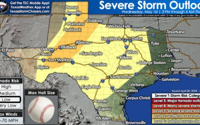
Let’s start out by looking at the latest severe weather outlook from the Storm Prediction Center. We have a large category 2 risk of severe weather in place today. The category 2 risk, known as a slight risk or elevated risk, is the ‘standard’ risk level during most severe weather days. Anything above that becomes subsequently more rare and the category 1/marginal risks are more common for strong to maybe a severe storm. The category 2 risk, shown in yellow, includes parts of the Permian Basin, Concho Valley, Big Country, Hill Country, North Texas, into parts of Central Texas. This zone has been expanded east/northeast and includes a line west of a Bonham to Terrell to Round Rock to San Antonio to near Eagle Pass.
The first potentially stronger storms should start firing up by 1-3 PM in the Permian Basin. This will occur as a strong negative-tilt trough kicks into the Borderland and far West Texas. For the few hours these storms should remain semi-discrete as they move east toward the western Concho Valley. It is during this timeframe where some of the storms may be supercellular with a risk of large hail, localized damaging winds, and the potential for a couple of tornadoes. This activity will generally move east/northeast around 40 to 50 MPH. By 5-6 PM we’re expecting the storms moving into the Big Country and Concho Valley to be more linear, or at least more semi-discrete versus just flat out discrete. The more intense storms will likely be severe with a threat of large hail, damaging winds, and the continued threat for a couple of tornadoes. The tornado threat will be highest with intense, semi-discrete supercells.
Onto the more conditional risk this evening. There is now an increased chance of isolated thunderstorms developing ahead of the squall line in North Texas. These storms would be in the open warm-sector and in an enviornment with very strong wind shear. The primary question is how far north a warm front, and associated instablity, will make it. Should the front make it into D/FW by early evening there is the potential for severe thunderstorms in D/FW between 4 PM and 9 PM with this first round of storms. Some of the storms may become supercellular with a risk of a few tornadoes. This is conditional and far from certain, but a concern we’re watching closely. We’ll keep you updated since this would obviously bring high-impact weather into D/FW during a playoff game. Stay tuned for updates throughout the day and have a way to receive warnings.
What is more likely is that we’ll see a line of strong to severe storms moving east through the Big Country into Northwest Texas, North Texas, into the Hill Country by 9-11 PM. The strongest storms in this line will likely be strong with a risk of damaging wind gusts, hail, and brief tornadoes. Localized flooding will also be possible. This squall line should be entering the D/FW Metroplex between 10 PM and 12 AM, ending from 11 PM to 2 AM (west to east). Keep in mind this will be the second round of storms should we see the first round materialize earlier in the evening. As the line of storms approaches Interstate 35/35E they’ll be outrunning the instability axis – lowering the risk of severe storms east of I-35/35E. There will still be rain/storms, but the risk of severe storms should decrease after midnight based on the current projections. We’ll then head into Monday and continued storm chances east of a cold front.


0 Comments