
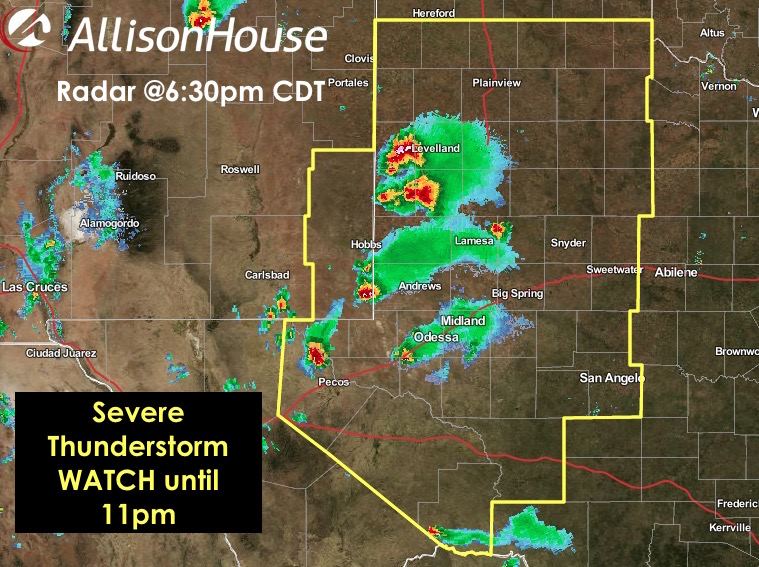
 A Severe Thunderstorm WATCH has been posted for parts of west and southwest Texas until 11pm CDT. Storms ongoing across the western south plains between Lubbock and Midland are expected to continue to develop and spread further east as we head into the evening hours. Coverage of storms will not be widespread which means not everyone will see storms, but any of the stronger storms that develop will have the chance of large hail up to 2 inches and damaging wind gusts in excess of 70mph. The tornado threat is low, but is non-zero. Residents in the Watch area are encouraged to stay abreast of the weather this evening and have a way to receive weather warnings should any be issued.
NWS STORM PREDICTION CENTER NORMAN OK
   405 PM CDT THU MAY 14 2015

   THE NWS STORM PREDICTION CENTER HAS ISSUED A

   * SEVERE THUNDERSTORM WATCH FOR PORTIONS OF
     FAR SOUTHEAST NEW MEXICO
     WEST AND SOUTHWEST TEXAS

   * EFFECTIVE THIS THURSDAY AFTERNOON AND EVENING FROM 405 PM UNTIL
     1100 PM CDT.

   * PRIMARY THREATS INCLUDE...
     SCATTERED LARGE HAIL AND ISOLATED VERY LARGE HAIL EVENTS TO 2
       INCHES IN DIAMETER POSSIBLE
     ISOLATED DAMAGING WIND GUSTS TO 70 MPH POSSIBLE
     A TORNADO OR TWO POSSIBLE

   SUMMARY...STRONG TO SEVERE THUNDERSTORMS ARE EXPECTED TO STEADILY
   INCREASE ACROSS SOUTHEAST NEW MEXICO AND INITIALLY WEST/SOUTHWEST
   TEXAS LATE THIS AFTERNOON AND EVENING. STORMS MAY MERGE AND SPREAD
   EASTWARD ACROSS ADDITIONAL PORTIONS OF WEST TEXAS THROUGH MID/LATE
   EVENING.

   THE SEVERE THUNDERSTORM WATCH AREA IS APPROXIMATELY ALONG AND 90
   STATUTE MILES EAST AND WEST OF A LINE FROM 55 MILES EAST
   SOUTHEAST OF FORT STOCKTON TEXAS TO 20 MILES NORTHEAST OF LUBBOCK
   TEXAS.
Advertisements


0 Comments