
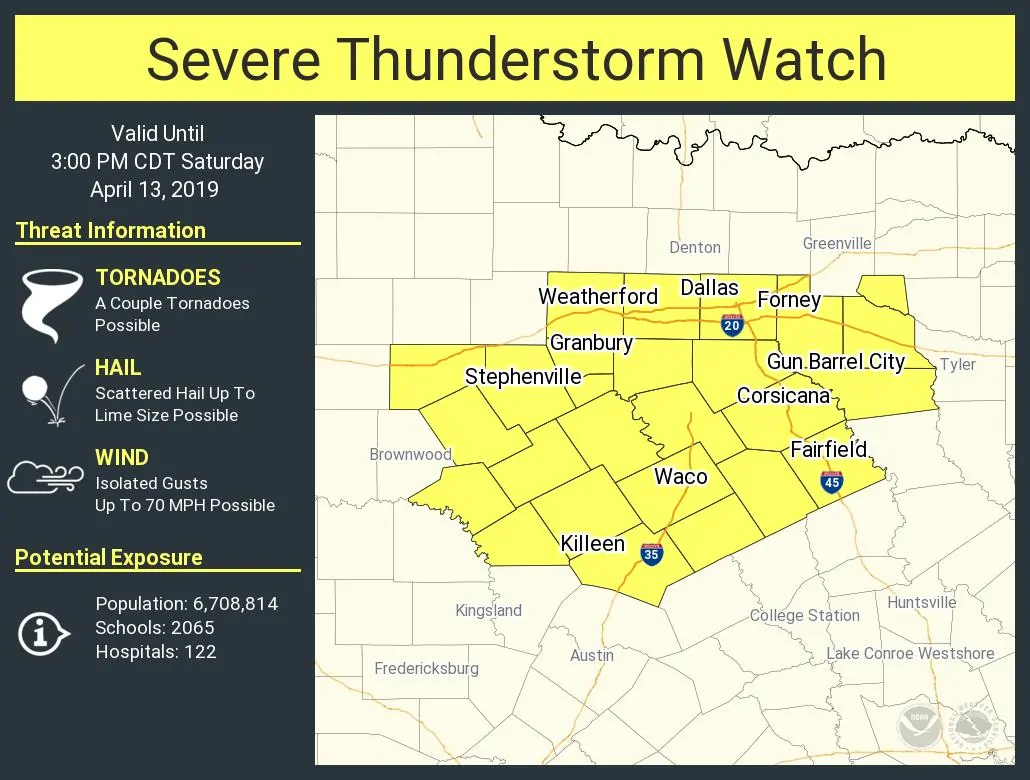
A new severe thunderstorm watch has been issued for much of North Texas. This watch is in effect until 3 PM. Stephenville, Weatherford, Fort Worth, Dallas, Forney, Gun Barrel City, Corsicana, Fairfield, Waco, and Killeen are included in this watch. Southern portions of this watch may be upgraded to a tornado watch later this morning, along with those in Central Texas and the Brazos Valley who are not under a watch at this time. A line of storms in the eastern Concho Valley/eastern Big Country is moving east/northeast. Those storms may contain hail and gusty winds. We’ll also be watching for new storm development over the watch area in the coming hours. Most storms will move north – with the strongest producing quarter to golfball size hail through the morning and early afternoon hours. The higher threat for tornadoes will be south into Central Texas, the Brazos Valley, and East Texas this morning and this afternoon.
Have a way to receive severe weather warnings and remain aware of the weather throughout the day. We’re expecting a new severe weather outlook from the Storm Prediction Center in the next 10-15 minutes. Once it is out we’ll have a more detailed forecast update posted by 8:30 AM.
Try out our free HD interactive weather radar to keep track of storms. Click here to try it out.
Severe Thunderstorm Watch Number 50
   NWS Storm Prediction Center Norman OK
   750 AM CDT Sat Apr 13 2019

   The NWS Storm Prediction Center has issued a

   * Severe Thunderstorm Watch for portions of
     Central and north-central Texas

   * Effective this Saturday morning and afternoon from 750 AM until
     300 PM CDT.

   * Primary threats include...
     Scattered large hail and isolated very large hail events to 2
       inches in diameter possible
     Isolated damaging wind gusts to 70 mph possible
     A tornado or two possible

   SUMMARY...The elevated northern segment of a complex of
   strong-severe thunderstorms initially over west-central Texas, and
   north of a warm front, will pose a threat for hail and occasional
   damaging gusts as it moves over the watch area.  A tornado cannot be
   ruled out, especially over southern parts of the watch, as the air
   mass destabilizes later this morning.


0 Comments