
It’s April in Texas, so severe storms aren’t unusual. Dealing with three Mondays in a row of severe weather chances? That is a bit interesting, or at least annoying. We need the rain, but we don’t need the frozen chunks of ice or flying trampolines. Most of our team will be chasing later today and tonight as storms move into North Texas. Today isn’t a ‘tornado chase day’ like a few weeks ago, but impactful weather is still expected. You’ll be able to watch several of their live streams on our YouTube channel. We’ll also have live severe weather coverage this evening and overnight – which will be available on most of our social media platforms and here on our website and mobile app.
Today’s Severe Weather Outlook
Severe weather outlooks issued by the Storm Prediction Center utilize a five-level risk scale. Each risk level is based on the probability of severe storms within twenty-five miles of any given point, such as your location. A level one risk is the lowest and means isolated/short-lived severe storms are possible. A level five risk is the highest, is quite rare, and indicates a significant tornado outbreak or derecho is likely. Being in or near any risk zone means you may have stronger storms in your vicinity.
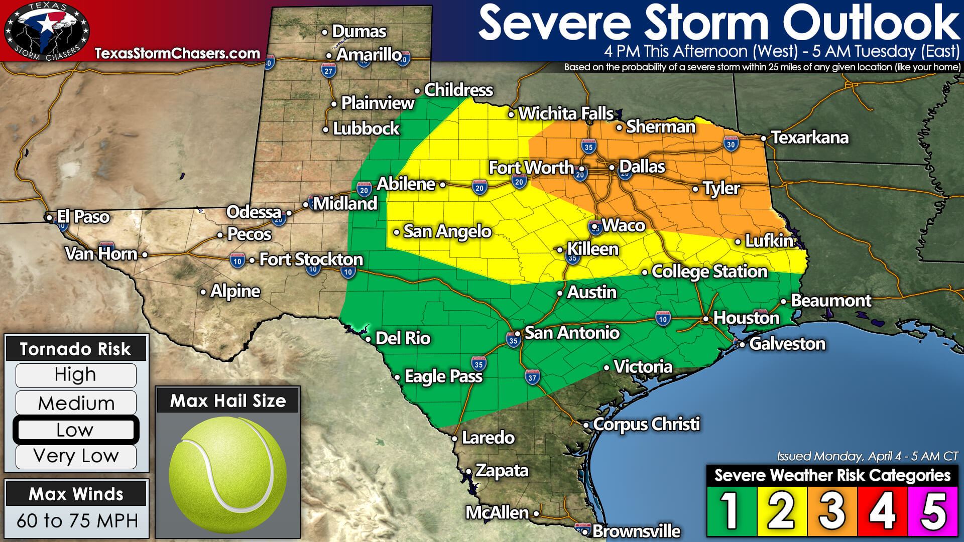
A level three out of five risk for severe thunderstorms – including widespread damaging straight-line winds – includes North Texas, Northeast Texas, and East Texas. Bowie, Mineral Wells, the D/FW Metroplex, Sherman, Texarkana, Tyler, Nacogdoches, Fairfield, to Hillsboro. The standard level two out of five risk for severe storms includes Northwest Texas, the Big Country, the Concho Valley, Central Texas, and the northern Brazos Valley.
Compared to yesterday’s update, we’ve seen that risk expand a bit further west and south. Finally, a level one out of five risk for severe storms includes the Edwards Plateau, Hill Country, South-Central Texas, the Coastal Plains, Southeast Texas, and the Golden Triangle. The highest concentration and number of severe storms are likely in the level three risk zone. Coverage becomes more isolated in level 2 and sparse in level 1.
Threats
The primary severe weather threat in Northwest Texas, the Big Country, the Concho Valley, and western North Texas will be damaging hail. We could see hail up to the size of tennis balls, perhaps a bit larger, in the most intense discrete supercell thunderstorms late this afternoon into the mid-evening hours.
Elsewhere, we’ll see the threat of damaging straight-line winds and large hail up to the size of golfballs. Destructive straight-line winds over 70 miles per hour may become more widespread across North Texas and East Texas tonight – including the threat of wind-driven hail. A few tornadoes are also possible, and we’ll closely monitor conditions.
Timing and detailed discussion
Showers and thunderstorms will likely be ongoing for most of the day across Southwest and Central Oklahoma. That activity will help push a cool front/outflow boundary south of the Red River this afternoon. By this evening, the outflow boundary may be a catalyst, or at least an enhancement, to severe weather probabilities in parts of North Texas. Specifically, we may see a corridor of enhanced low-level wind shear and ‘lift’ by early evening.

4 PM through 9 PM
Our first stronger storms of the day south of the Red River may begin forming around 4 to 5 PM in Northwest Texas south along a dryline into the Concho Valley. Dominant storm movement will be to the northeast. A few stronger, discrete cells may intensify into supercells and start moving more easterly. Large to damaging hail will be likely with supercelluar thunderstorms. Localized damaging wind gusts and a low tornado threat will also exist. Low-level wind shear is not expected to increase until after 7 PM, so activity this afternoon won’t have an overly impressive low-level environment to work with.
Scattered severe thunderstorms will continue through the early evening across Northwest Texas and the Big Country – and progress into western North Texas. Between 7 PM and 9 PM – we’ll start to see thunderstorms grow upscale into a cluster or squall line in western North Texas. That complex of thunderstorms will begin moving east and, eventually, moving east/southeast as it accelerates toward the D/FW Metroplex and Interstate 35 corridor.
Storms approach I-35 in North Texas (including D/FW) after 9-10PM
Severe weather is likely to occur in the D/FW Metroplex between 10 PM and 12 AM tonight as storms move east/southeast. Impactful severe weather is possible, including wind-driven hail, destructive straight-line winds, and the potential for brief embedded tornadoes. We’ll also have to watch for any cells that try to develop ahead of the main complex – since those ‘discrete cells’ would have to be watched for tornado potential.
More isolated storms are likely to continue through the late evening across the eastern Concho Valley into Central Texas. We’re seeing indications that storms south of Highway 84 may start to struggle and weaken by 12 to 1 AM. That will not be the case farther north, where the substantial upper-level lift will continue to offset the loss of daytime heating.
12 AM through 5 AM Tuesday
Between 12 AM and 2 AM, a complex of severe thunderstorms will move east/southeast into Northeast Texas and East Texas. Destructive straight-line winds over 70 miles per hour, wind-driven hail up to the size of golfballs, and brief tornadoes are likely with the most intense storms. Not all storms within the complex/squall line will be severe, but we’re expecting some gnarly straight-line winds.
We want to make a point about falling trees on structures and roads tonight across Northeast & East Texas. Please be mindful of the falling tree hazard and take appropriate precautions if dangerous storms approach. Tornadoes get plenty of attention, but straight-line winds can be very impactful too. The primary complex of thunderstorms will move east into Louisiana by 4 AM Tuesday.
Lagging storms may continue across East Texas through sunrise Tuesday. Some of those ‘laggers’ may be capable of producing pocket-change size hail and localized damaging wind gusts. Our primary severe weather window will be from 5 PM today in the west to 4 AM along the Texas and Louisiana border.


0 Comments