
Yesterday was another reminder that even the ‘10% chance of severe storms’ occasionally happens. A vast majority of weather models said the dryline would remain ‘capped.’ The cap did break, and a supercell produced hail up to the size of baseballs and wind damage over a 150-mile path from 4:30 PM to 10:30 PM (ish) yesterday in southern North Texas and the Brazos Valley. When we say Mother Nature doesn’t care about the maps or lines we draw – we’re not kidding.
When we say there may only be one or two storms, but those storms will be quite impactful – we’re not kidding. Sometimes the cap holds tough, and it’s a ‘blue sky bust’ (clear and sunny skies). Other times, the cap breaks, and you end up with a supercell producing damaging hail. Luckily, low-level wind shear was weak yesterday. Otherwise, hail and damaging straight-line winds wouldn’t have been the only issue.
Severe Weather Outlook
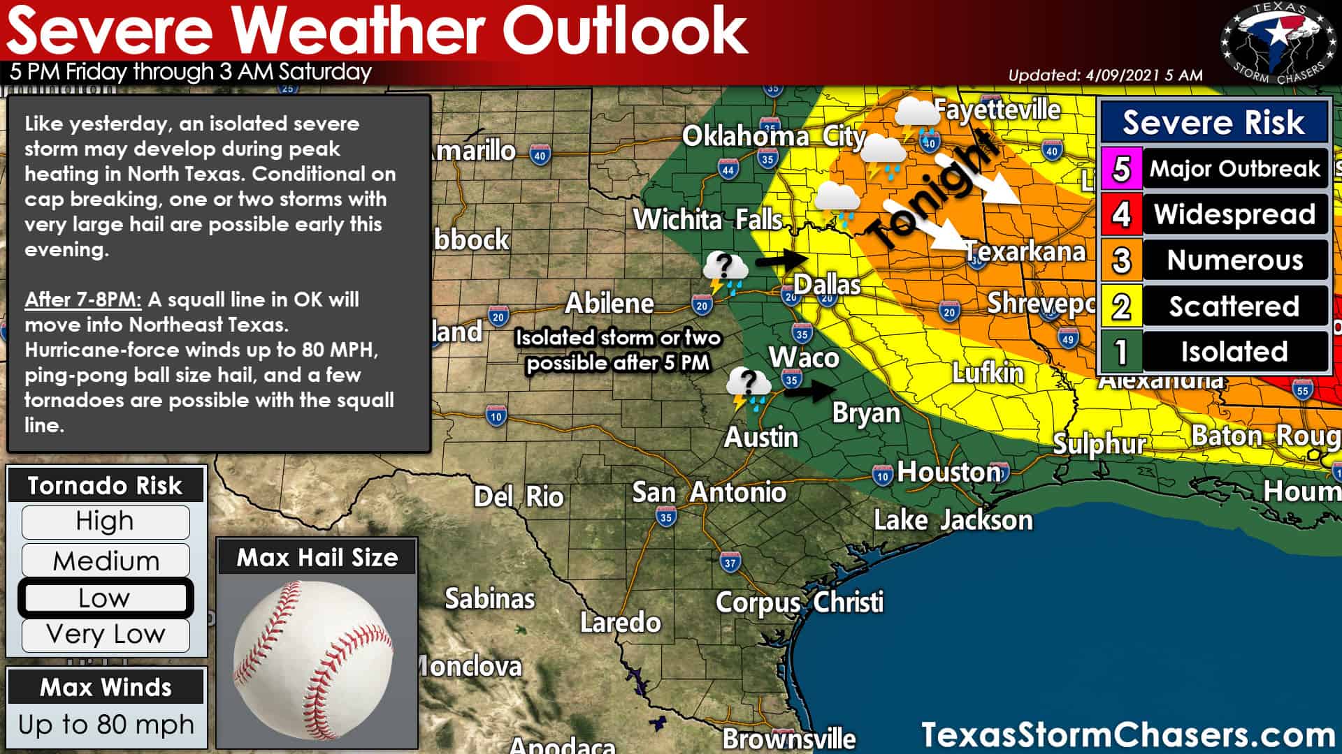
The Storm Prediction Center has issued a severe weather outlook highlighting North Texas, Northeast Texas, and East Texas for later today and tonight. I want to remind folks that the ‘risk levels’ do not represent the severity of storms but the ‘coverage or number’ of severe storms. The most intense storms today may produce very large hail, damaging straight-line winds, and perhaps a few tornadoes. It does not matter if the storm is in a level one risk or a level three risk – the hazards are identical. Goodness, yesterday’s Brazos Valley supercell wasn’t even technically in an official ‘risk level.’ That’s how unexpected yesterday’s supercell was up until around 3:45 PM.
Timing, Hazards, and Weather Nerdiness
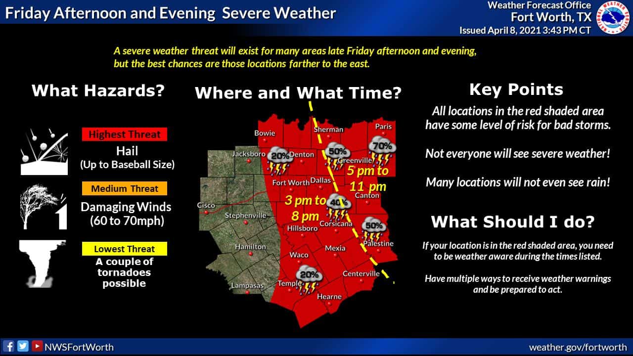
There are two regions we’re watching for storm development today. The first is just east of the dryline in Texoma, North Texas, and Central Texas. Like yesterday, there is uncertainty if the cap will be weak enough for a thunderstorm to punch through. I think we will see at least one storm get going after 5 PM, and it could become severe. Most folks in North/Central Texas will not see thunderstorms today. However, any isolated storms that do develop will likely be severe with impactful severe weather. One storm yesterday produced millions of dollars in hail damage in Bryan/College Station alone – with more hail/wind damage farther west. The same thing could happen today for anyone who ends up under an isolated storm. If the cap holds and we end up with a quiet afternoon? Good. I can go finish doing yard work that Mother Nature rudely interrupted yesterday.
Of higher confidence is the forecast for Southeast Oklahoma and Northeast Texas this evening. Scattered severe storms should fire up after 3 PM near a cool front from west of Tulsa to near Oklahoma City. Those storms will grow upscale into a squall line that starts moving southeast around dinner-time. By the time the squall line, or a broken line of severe storms, approaches the Red River (probably east of Interstate 35, maybe well east of Highway 75) after 7 PM, we anticipate damaging straight-line winds, large hail, and perhaps a few tornadoes to be ongoing.
Severe storm chances increase after 7 PM in Northeast Texas.
The highest potential (in terms of thunderstorm chances and coverage this evening) should be in Northeast Texas. That is where the Storm Prediction Center has a level three severe weather risk highlighted. We’re still unsure on how far south/southwest storms will develop this evening. Only the far Northeastern Texas counties (Red River) may be impacted. It is also possible the squall line tries to build south or does build south of Interstate 20 in East Texas tonight. We also need to keep an eye out for any discrete supercells that try to fire up in Northeast/East Texas around dinner-time.
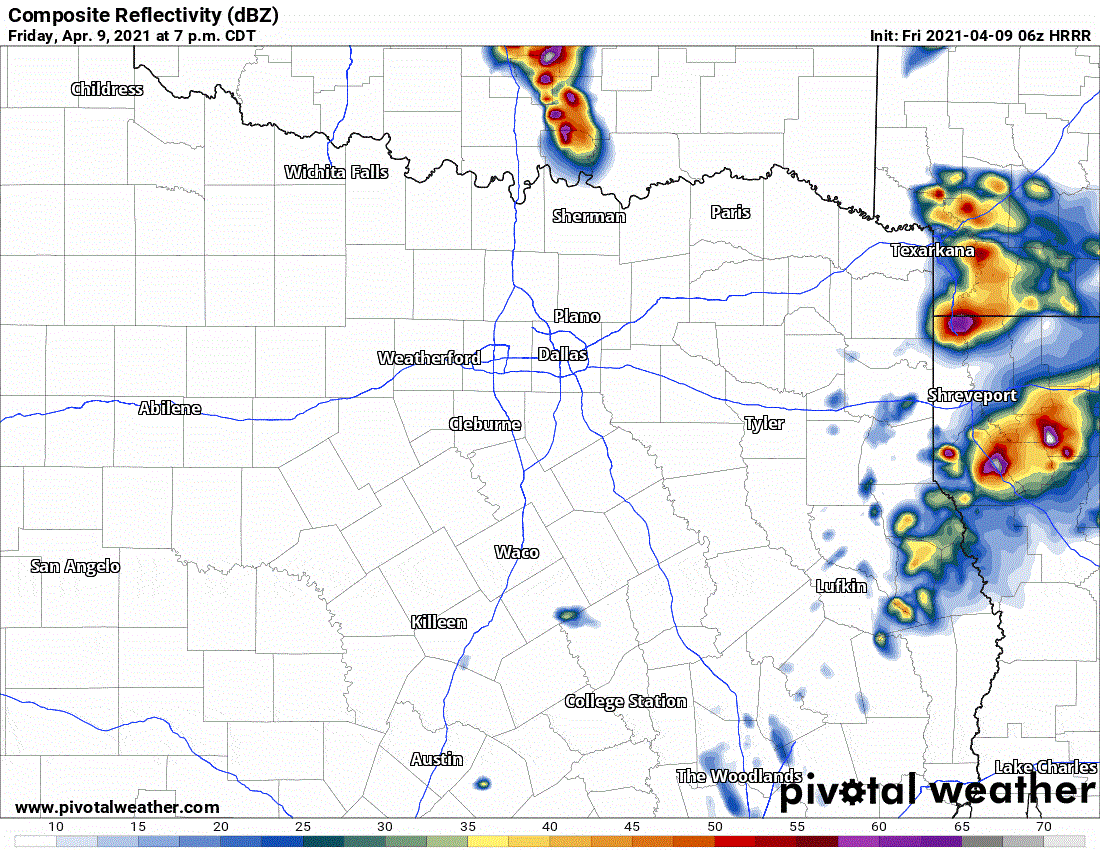
One weather model showing a simulated weather radar depiction this evening. This specific model does not show cells further west near Interstate 35, but understand it is possible; like yesterday, we have a few hailers underway after 5 PM.
Regardless, the most intense storms are expected to be severe, with all modes of severe weather possible. Some straight-line winds may be in the hurricane-force category (75+ MPH). Tornadoes are not out of the question, but hopefully, storms will remain linear (a squall line) versus any supercelluar storm structures. Regardless, take the damaging straight-line wind threat seriously tonight. 80 MPH winds, whether they are straight-line or tornadic, will cause significant tree damage. Trees tend to fall on structures, block roads, and cause havoc. We don’t need anyone getting hurt from a tree falling on their home or someone driving at high speed into a tree that’s down on the road late tonight. Northeast Texas and East Texas contain plenty of beautiful, dense forests. That means we’re more concerned about big-time tree damage (and the dangers falling trees pose) versus areas west of Interstate 35/45.
When will the storms be gone?
If we have a squall line build south to Interstate 20 this evening, we could deal with storms in East Texas through 2-3 AM Saturday. Regardless of your risk level, we encourage folks in Texoma, North Texas, Central Texas, the Brazos Valley, Northeast Texas, and East Texas to remain weather aware later today and tonight. We don’t want anyone getting surprised if a storm ends up trying to visit them. Yet, most folks outside of Northeast Texas won’t see a thunderstorm today.
Live streaming plans, notes, randomness.
It’s April in Texas – days like this are typical. I, baldy-in-chief here at Texas Storm Chasers, will be providing severe weather coverage later today on our social media platforms. Remember: If there is a tornado warning in Texas, we’re likely going to be doing ‘live coverage’ on our YouTube Channel. We’ll do our best to embed it so folks can watch it on our website, but we hope you’ll follow us on YouTube too!
After tonight, we’re done with severe thunderstorms for a while. A relatively cool weather pattern for April sets up shop next week. We’re hopeful a cool, wet pattern sets up shop to help reduce some of the drought. The overall pattern next doesn’t support big-time severe weather issues. In fact, there’s a chance some of the TSC crew might be taking a trip up to Colorado if they manage to get a big winter storm next week. Snow chase in April, anyone?


0 Comments